• facebook
  • Twitter
  • Linkedin
  • Youtube
  • Linkedin Group
  • Post a Job
  • Post an Ad
  • Post an Event
  • Post a Directory Listing
  • Post a Press Release
  • Media Kit
  • My Account
  • Login
GoGeomatics
  • MAGAZINE
    • BIM & GIS
    • Community
    • Conference news
    • Earth Observation
    • Education & Careers
    • GEOAI
    • Announcements
    • Reality Capture & Lidar
    • Science
    • Technology
  • Directories
    • ASSOCIATION
    • INDUSTRY
    • EDUCATION
    • Open Data
  • EVENTS
    • GeoIgnite Events
    • Events Calendar
    • GoGeomatics Meetups
  • Services
    • Advertising
    • Marketing
    • Post a Job
    • Post an Ad
    • Post an Event
    • Post a Press Release
    • Post a Directory Listing
    • Media Kit
    • Web Design
  • Find a Job
  • Volunteer
    • Start a GoGeomatics Group
    • Editors & Writers Group
  • About Us
    • About Us
    • Contact Us
    • Frequently Asked Questions
  • Videos
HomeLODE

LODE

|||||
Technology

Building-height Estimation using Street-view Images, Deep Learning, and Building Footprints

12 February 2021 Ala'a Al-Habashna | 3D maps

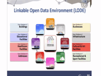
Introduction Building height is an important piece of information that has various important applications such as economic analysis, urban planning, and development of 3D city maps. For many geographical areas, such information is not accessible […]

|
Technology

GeoIgnite 2020 Video: Statistics Canada DEIL experiments and outputs with open geospatial data

14 October 2020 Saeideh Hejazi | Alessandro Alasia

GeoIgnite is Canada’s National Geospatial conference hosted by GoGeomatics Canada. GeoIgnite was held online using Zoom from July 22nd to 24th, 2020.  This event showcased Canadian geospatial community and leaders of Canada’s location technology sector. The […]

||||
Technology

The Linkable Open Data Environment (LODE): Supporting Geospatial Analysis with Open Data

9 September 2020 Julia Conzon and Joseph Kuchar | Data Exploration and Integration Lab

Over the past 2 years Statistics Canada’s Data Exploration and Integration Lab (DEIL) has launched and developed the Linkable Open Data Environment (LODE), an exploratory initiative that aims at enhancing the use and harmonization of […]

Events

Notice
There are no upcoming events.

View All Events

Services

  • Post a Job
  • Post an Ad
  • Post an Event
  • Post a Directory Listing
  • Post a Press Release
  • Media Kit
  • My Account
  • Login

Jobs

Post a Job
  • Canada Maps and Poster Gallery Volunteer Leads — GeoIgnite 2026
    remote
  • GIS & Data Analytics Lead
    Beaumont, AB
  • Lead Surveyor, Projects/Arpenteur-géomètre principal, projets; arpenteuse-géomètre principale, projets
    North Bay, Thunder Bay
  • Senior GIS Developer
    Calgary, AB
View All Jobs
  • Directories
    • Associations Directory
    • Industry Directory
    • Education Programs
    • Open Data
  • Volunteer
    • Start a GoGeomatics Group
    • Editors & Writers Group
  • About Us
    • GoGeomatics Media Kit
    • Who We Are
    • Contact Us
    • FAQ’s
    • Advertising
    • Marketing
  • Subscribe
GoGeomatics
GoGeomatics is the largest and most popular communications hub promoting the Canadian geospatial community. The business was incorporated in 2011. GoGeomatics hosts over 100 fun, free, location technology networking events each year in cities across Canada.

© 2025 GoGeomatics

  • facebook
  • Twitter
  • Linkedin
  • Youtube
  • Linkedin Group