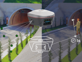
mobile mapping
Geo Week 2023 – Cool Stuff!
The Geo Week exhibition and conference, held in Denver Colorado, February 13-15, attracted 3,000 attendees from over 50 countries. And…
NavVis’ Exciting Addition to Canadian Surveyors’ Toolkits
New geomatics tech is always exciting when I come across it. So, it was doubly exciting to me that GoGeomatics…
Canadian Utility Locators Level Up with PointMan Software: Now Critical Part of LMI Certification Program
The flagship product of ProStar, called PointMan, has now become part of the LMI (Locate Management Institute) of Canada Certification…
The State of Mobile Mapping Report 2022 is here: Find out what the industry has to say
Brought to you by NavVis in partnership with GoGeomatics, Lidar News, Lidar Magazine, the American Surveyor, GIM International, Geo Week,…
Does mobile mapping belong in surveying? These surveyors think so
By Sean Higgins Two professional surveyors share three secret benefits of mobile mapping systems. Today, licensed surveyors are starting to…
Avoiding a Pointless-verse
A “metaverse” holds so much potential beyond just social media and marketing platforms. Substantive uses for infrastructure design, construction, and…
NavVis Changes the Game with Dynamic Mobile Mapping
During a LiDAR COMEX 2022, live stream on April 5, 2022, participants heard Marek Koltun, Senior Account Executive – Enterprise…
DGT Combines Traditional and Advanced Technologies to advance Unground Mapping
Best practices come from using radar tomography to augment underground utility locating. SUMSF live stream on March 23, 2022, treated…
The State of Mobile Mapping 2022 is here: You’re invited to take part in the industry survey of the year
You’re invited to take part in one of the biggest and most ambitious surveys ever conducted about mobile mapping. NavVis,…
International Geospatial Briefing May 9th: 1. Canopy mapping helps council; 2. Capella Space funding will enhance AI-enhanced geospatial data; 3. Space Force has insatiable demand for geospatial intelligence; 4. A sharper look at the world’s rivers and catchments; 5. Developing a Virtual Laser Scanner for Training and Research; 6. NASA Develops Lidar Backpack Technology
Canopy mapping helps council Capella Space funding will enhance AI-enhanced geospatial data Space Force has insatiable demand for geospatial intelligence…
Elexicon Energy and Quantum Spatial Canada Pilot Comprehensive Mobile Mapping Project
Elexicon Energy (Elexicon) was formed in April 2019 by the merger of Veridian Connections and Whitby Hydro Electric Corporation. Owned…