
Survey

Discover ITRES at the GoGeomatics Expo
We are thrilled to announce that ITRES is exhibiting at the GoGeomatics Expo, Nov 6-8th in Calgary. ITRES (1979) is…

Ten Years Later: Interview with Wendy MacIsaac one of Canada’s Top Surveyors
Ten years ago, GoGeomatics interviewed Wendy MacIsaac of Midwest Surveys Inc. in Calgary, Alberta, about her career and being a…

The ACLS Wants You: Geodetic Datum Dependencies Survey
The Association of Canada Lands Surveyors (ACLS) invites you to participate in the Geodetic Datum Dependencies Survey. It is a…

2022 Back to School Socials in Pictures – Thank you Sponsors & Participants!
The 7th annual GoGeomatics 2022 Back to School Socials have been a tremendous success. Our groups and group leaders across…

NV5 Geospatial Supports Natural Resources Canada in Topobathymetric Lidar Survey of South and North Saskatchewan Rivers
Over the last decade, a growing number of municipal and regional governments across North America have invested in topobathymetric lidar…

The State of Mobile Mapping 2022 is here: You’re invited to take part in the industry survey of the year
You’re invited to take part in one of the biggest and most ambitious surveys ever conducted about mobile mapping. NavVis,…
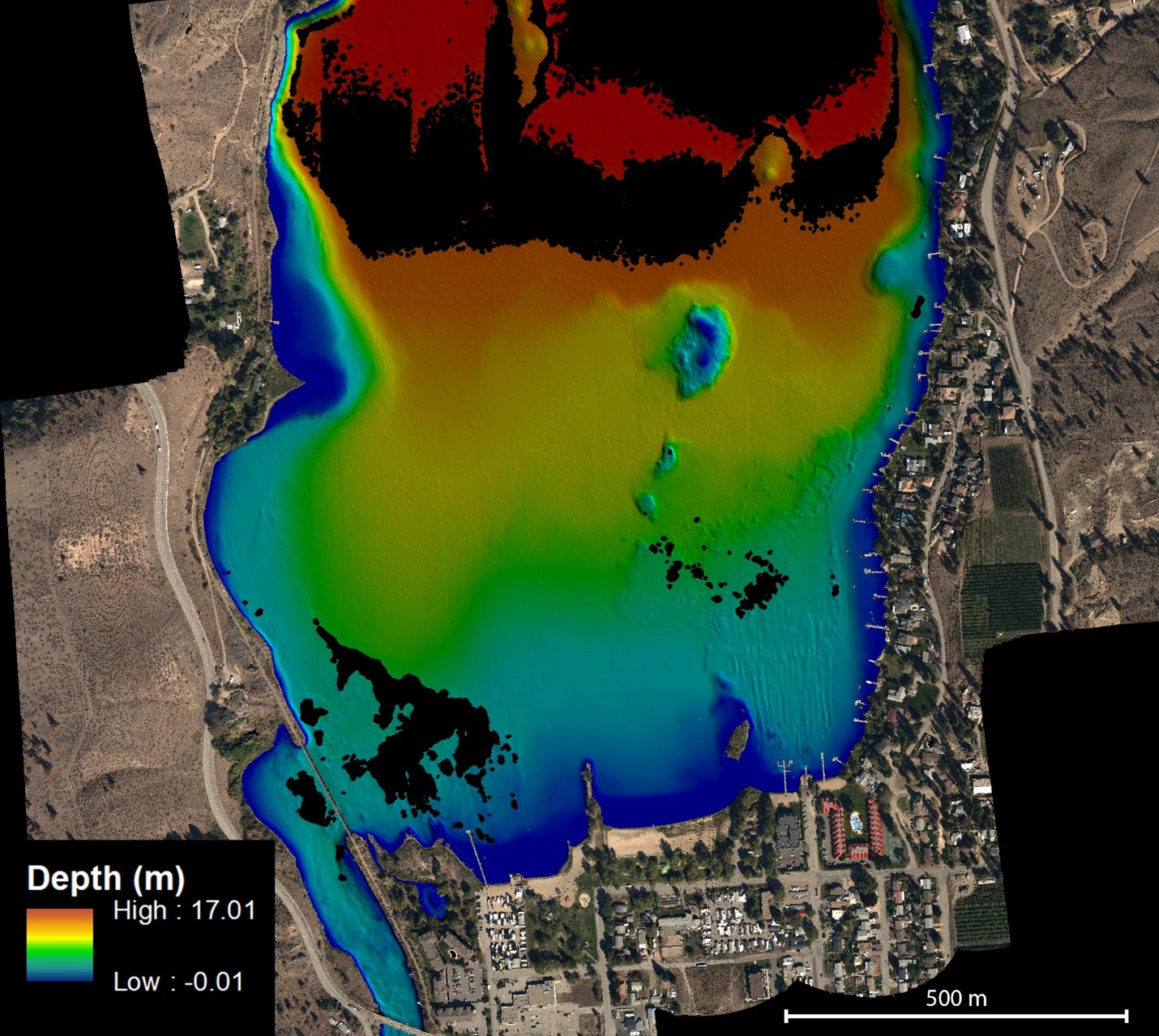
NV5 Geospatial Helps Okanagan Basin Water Board Protect Important Local Communities Through Near-Shore Topobathymetric Lidar Survey
The Okanagan Valley in British Columbia is one of Western Canada’s most attractive tourist destinations, with local communities offering a…

Take the Survey: Canadian “Geo” Associations Survey
GoGeomatics Canada is conducting a survey of the Canadian geospatial community to see what you think about associations in our…
Results: Pandemic Survey of the Canadian Geospatial Sector
In October of 2020, GoGeomatics Canada conducted a survey of how the Canadian geospatial sector was coping with the global…

Canadian Geospatial Briefing for October 7th: EA Event Hosted By Government of Canada; Geosapiens Startup Business; Drone Delivery Canada; Alberta Greenhouse Report
The Government of Canada to host webinar for its Space-Based Earth Observation strategy Canada Space Agency(CSA) has released which defines…
Geospatial Certifications Survey: GIS, Remote Sensing, Surveying, and Geomatics
GoGeomatics is hosting a survey to ask your opinion on the different certifications available. GoGeomatics is hosting two live events…

Quantum Spatial Canada Supports Disaster Preparedness on Vancouver Island Through Lidar Survey Covering 9000 Square Kilometers
Located off the Pacific Coast of British Columbia, Vancouver Island is home to just under 900,000 people, as well as…
