
web-based

One of the Best Geomatics events in Canada: GeoAlberta 2017
I had a chance to attend the 2017 GeoAlberta conference earlier this month in Calgary, Alberta. This was my first…
Esri Canada Community Maps Program: Why more communities need to take advantage of this
The Community Maps Program (CMP) was introduced by Esri Canada in 2009 allowing organizations to share and host geographic data. …

Event Recap: COGS & CIG & GANS Cooperate for Mapping Workshop
The Canadian Institute of Geomatics (CIG) Nova Scotia Branch and the Geomatics Association of Nova Scotia (GANS), two regional professional organizations that foster the application of geographic information within the geomatics sector recently collaborated to host a high resolution mapping workshop at the Centre of Geographic Sciences (COGS) in Lawrencetown, Nova Scotia.

Geospatial Development: Enhancing GIS curricula with programming skills at UNB
Geospatial information science and technology (GIS&T) has rapidly evolved over the last few decades. This evolution has created a highly…
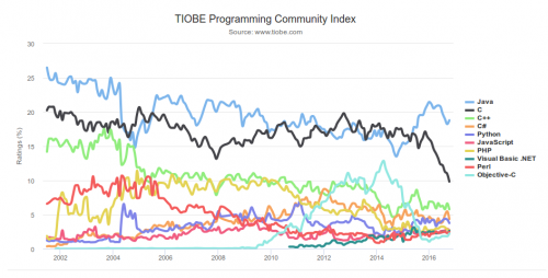
What are the Top Programming Languages in the GIS World?
Image source: www.tiobe.com Every now and again we hear about the importance of programming for Geographic Information Systems(GIS) professionals, that…
Jessi Mielke Esri’s Certification Manager Chats About the Esri Technical Certification Program
For the last 6 months I’ve been writing articles and discussing my experience in regards to the Esri technical certification…
Putting Map Making Back Into the Hands of the Community
On April 7th, I attended the community mapping showcase at the NSCC Centre of Geographic Sciences (COGS). This project is…
FAA Announces Small UAS Registration Rule
For Immediate Release December 14, 2015 Contact: Les Dorr or Alison Duquette Phone: (202) 267-3883 Registration Begins on December 21,…
Web Framework for Flood Risk Assessment: Elevation Services and Simplified Flood Models
The development of infrastructure and dense urbanization along water courses and the increasing severity of storm events has brought to…
Web Mercator: the de facto standard, the controversy, and the opportunity
Four hundred and fifty years ago, the Flemish geographer and cartographer Gerardus Mercator presented the most popular map projection ever.…
Nova Scotia Power Wins Esri Special Achievement in GIS Award
Enterprise implementation of geospatial platform transforms electric utility operations San Diego, CA, Esri International User Conference – Esri Canada congratulates…
DisasterLAN Successfully Implemented by Alberta’s Emergency Management Agency
After a competitive RFP process, the Alberta Emergency Management Agency (AEMA) has chosen Buffalo Computer Graphics’ (BCG) DisasterLAN (DLAN) as…
