Wiki

A Canadian Geographer’s Notes from Nunavut

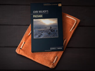
For the last five years, I have annually had the opportunity to spend time in Iqaluit, Canada’s fastest growing community in Canada’s fastest growing territory or province. On arrival, I check out the selection of new books at Arctic Ventures and the screening of new movies about the North. This year, there was the chance to see John Walker’s Passage and to buy a copy of Darrel Varga’s book of the same name in the Canadian Cinema series.

Student Passion for Geography and the Google Summer of Code

GoGeomatics has reached across the Atlantic to interview one of our new geospatial contributors in Europe. Join us as we…

Google Summer of Code Projects: Open Source Geospatial 4 every student

Are you are university student who has solid programming skills, geospatial knowledge and is continuously aiming to become better at…

Upgrade your Geospatial Skills: leveraging the power of MOOCs

What I want to share with you are some resources related to something called Massive Open Online Course (MOOC) where…

Graph Databases – Recent development in Neo4j may help accommodate the Geospatial Community

Graph Databases and GIS & Technology (GIS&T) In the era of big data, graph databases are becoming very popular as…

Easy Access to Data: The CGDI Initiative

The Canadian Geospatial Data Infrastructure (CGDI) is an initiative of Natural Resources Canada that began in 2001. The CGDI does…

QGIS & WorldClim: Using Zonal Statistics to Map Temperature Patterns

There has never been a time in the history of GIS when so much free, high quality data has been…

50 Years a Geographer: My Top Ten books about Geography

In celebration of Geography Week, it seemed like a good idea to issue a challenge: list the top ten books…

Postal Codes: Canada Post Backs Down on Crowdsourced Open Data

Have you ever felt the wrath of a Canadian Crown Corporation? In 2011 Canada Post set its sights on Ervin…

SaveTheMap Campaign: What is the future of geospatial information in India

SaveTheMap Campaign: “to encourage citizens and startups to use geospatial data in everyday lives and create businesses that serve India”…

NetCDF: a growing standard for encoding georeferenced data in binary form

Recently, the Open Geospatial Consortium (OGC) has announced an extension to the OGC CF-netCDF 3.0 encoding standard that specifies how…

Location Encoding Systems – Could geographic coordinates be replaced and at what cost?

Geocoding is the process of converting a street address into a physical location that can be described with a pair…