


Tim Webster: Interview about Past, Present, & Future: Applied Geomatics Research Group
Dr. Tim Webster, is a renowned research scientist with the Applied Geomatics Research Group (AGRG) in Middleton, Nova Scotia. He is one of the top researchers in the geomatics sector, specializing in flood risk mapping, shoreline delineation, and landscape evolution utilizing LiDAR and other remote sensing techniques.
The AGRG was founded in 2000, through financial support from the Canada Foundation for Innovation. The team consists of a team of research scientists, research associates, as well as a variety of interns and graduate students. They began using various geomatics tools and techniques for environmental research in the Annapolis Valley. Since then, their geomatics research projects have expanded to include multiple partners from both private and public sectors.
Recently the Canadian Institute of Geomatics (CIG) Nova Scotia Branch (of which Tim Chairs) and the Geomatics Association of Nova Scotia (GANS), recently collaborated to host a high resolution mapping workshop at the Centre of Geographic Sciences (COGS). The event that attracted people from Nova Scotia, New Brunswick, Newfoundland, Ontario and even Sweden brought together experts from the geospatial community to learn about the recent technological developments and to exchange views on the future directions of high resolution in geomatics research, applications and services.
Bob Maher, now retired was one of the research scientists responsible for the creation of the AGRG. While attending the workshop on behalf of GoGeomatics Bob got the chance to chat with Dr. Tim Webster, and find out what the AGRG has been up since then.
Bob Maher: Tim, I want to congratulate you on a successful two day workshop. I was impressed by the range of participants: ranging from international business leaders like Leica GeoSystems and Digital Globe to the AGRG team, local industry including Stantec Consulting and Leading Edge Geomatics, plus a variety of government partners.
 Tim Webster: Thank you, Bob. Having the CIG and GANS working together helped leverage more of the geomatics sector, and we were very pleased with the range and scope of both the presentations and the audience. I am sure that everyone who attended learned something and took home some new ideas, which in the end was the main objective of our workshop.
Bob Maher: We have worked together for many years. First at the Centre of Geographic Sciences (COGS) (e.g. TYDAC – Guilio Muffin and Michael Simmons) and then later at the AGRG (e.g. GeoNet – Mike Pearson and John Allen). I left the AGRG back in 2011, what changes have you seen in the last five years?
Tim Webster: Yes, we go back a long way to when I was a student and you were the department head and passed my major project on to TYDAC, which eventually led to them hiring me for my first geomatics job.
The biggest change since you left the AGRG has been the latest CFI grant, where I am Principal Investigator and it allowed us to purchase the Leica GeoSystem Chiroptera II topo-bathymetric LIDAR sensor. As well, we purchased some Leica GPS equipment, a MDL mobile laser scanner and an ocean worthy 24 foot boat. These tools combined together with our existing tools have allowed us to acquire data in areas where our previous technology lacked, now providing a more completed data set for more accurate analysis.
 The next biggest change would be in our staff, the college agreed to change some of our long time casual research roles into permanent positions. Although we still depend on soft money to pay them, they now have better job security and benefits. We still maintain a large group of casual employees, which includes programmers, graduate from the ocean technology program, as well as the usual COGS graduates.
In terms of research projects, we have leveraged the topo-bathymetric LiDAR sensor for several Natural Sciences and Engineering Research Council (NSERC) industry engaged projects ($25k for a six month project) and applied research and development projects which are $75k per year for three years. We currently have applied research and development projects with Acadian Seaplants and one with Leading Edge Geomatics. Other industry partners include the Gulf Region Fisheries Science Group on shellfish aquaculture research, and Department of Fisheries and Oceans for oil spill preparedness.
Bob Maher: What more can be done with respect to monitoring the coastal zone?
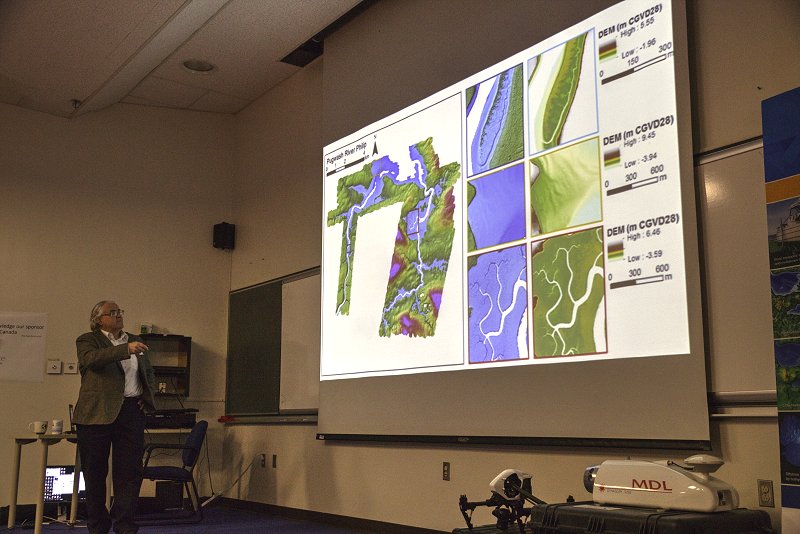
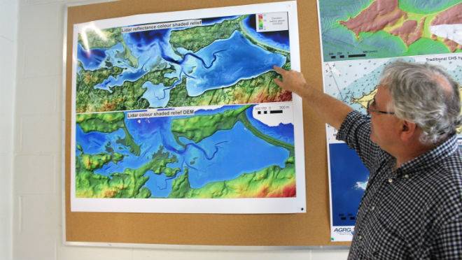
Tim Webster: The recent workshop focused on high resolution mapping in the coastal zone. In part, because it is such an important region to map and can be difficult when using traditional methods. The topo-bathymetric LiDAR and camera system is truly well suited for shallow water high resolution mapping. In addition to acquiring remotely sensed data, monitoring using in-situ instruments is playing a bigger role.
For example, deploying the Acoustic Doppler Current Profiler to ensure the water levels and currents in a bay. We are using these devices to validate our hydro-dynamic models we are developing that utilize the new high resolution topography, captured by the LiDAR. We will see more in-situ sensors for things like temperature and oxygen for example. We have some portable real time buoys that use a cell connection tops the turbidity values to the Internet. This is part of improving our operational efficiency in the LEG-NSERC project.
Bob Maher: How are we doing in meeting the demand for trained professionals in this field?
Tim Webster: We continue with the NSCC-Acadia M.Sc in Applied Geomatics. One area we would like to expand is the use of sensor and expertise in training and processing at the international level. I would love to team up with academic institutions in coastal areas where the top-bathymetric LiDAR could help with sustainable coastal development and conservation.
Bob Maher: Do you have any new projects in the pipeline, that you can mention?
Tim Webster: We recently learned that we have ACOA project funded that will allow us to build a 3-D visualization lab.We collect so much 3-D data and we usually visualize and process it in a 2-D environment. We are not doing the data or ourselves justice. The lab will include a new colour 3-D printer, 3-D displays, several Virtual Reality headsets and high end processing computers. We are excited about printing some of our new coastal maps using the 3-D colour printer, where we can drape imagery or colour by elevation to allow users to better understand the coastal zone.
Bob Maher: Thanks, Tim. It is good to hear that the AGRG has been able to continue to provide Atlantic Canada with state of the art research and I am sure that many people who missed your recent workshop will be looking forward towards the next one.


Nice interview and lots to look forward from Nova Scotia applied geo-scientists. I am particularly excited for AGRG to explore large mashup data sets via Virtual Reality technology — not only in our coastal zones but in LiDAR-mapped forests, and in dynamically-changing environmental data sets.