
UAV Technology in the Canadian Forestry Sector
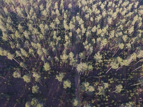
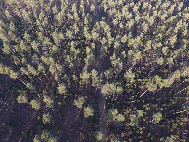
The Unmanned Aerial Vehicle (UAV) industry is soaring! Civilian drones are being applied in various global industries ranging from agriculture and mining to construction and film production. The potential of the application of UAVs in the forestry sector is of increasing interest to many forest managers due to the possibility of acquiring high resolution aerial imagery (<0.05m) and high density image-based or LiDAR point clouds at a relatively low cost and increased temporal resolution.
UAV technology could change the face of the forestry sector in more ways than one. Small-scale administrative strategies can be enhanced with an up-to-date birds-eye view of a management area and money can be saved with a minimization of costly aerial imagery acquired from satellite and manned aircraft missions. Furthermore, valuable time can be conserved in field surveys while insuring the safety of crews by reducing the need for “boots on the ground” in hard to reach areas [1,2]. Additionally, the skill sets required to implement UAV technology as well as associated image processing and analysis software could also influence the course content of Geomatics and Environmental related study programs induced from a growing geospatial job market.
 Why are businesses investing in this technology?
Low-altitude high resolution imagery acquired with UAV mounted multispectral sensors (RGB, NIR, and TIR) can aid in for example defoliation assessment, regeneration status updates, pre- and post-harvest assessment, wildfire hotspot scanning, and storm damage analysis. Additionally, UAVs can act as an eye-in-the-sky for inaccessible areas and wildlife management [1]. Due to advancements in Semi-Global Matching technology, photorealistic 3D representations of forest stands can be processed into accurate photogrammetric point clouds (PPCs) similar to those derived from Light Detection and Ranging (LiDAR) datasets. It is even possible to implement active sensors as a UAV payload to acquire LiDAR datasets. In contrast to aerial imagery originating from remote sensing platforms such as satellites and manned aircraft, UAVs have the ability to fly at regular intervals enabling up-to-date cost-effective management decisions on an operational and tactical scale. Furthermore, civilian UAVs normally fly at low altitudes resulting in high resolution imagery acquisition with minimal atmospheric distortion (e.g. cloud cover). UAVs are however limited in area coverage and are usually implemented on a smaller scale due to “line-of-sight” Transport Canada regulations [2] and limited battery capacity (20-40 mins), yet remain a valuable tool in operational forestry.
 Who is doing the flying? Who is processing the data?
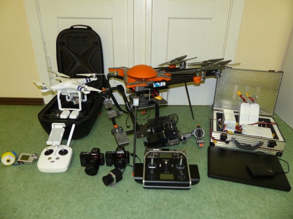
In a perfect world one could hire a UAV technician, a forester, a photogrammetrist, a remote sensing specialist, a GIS technician, and a programmer. Unless you are NASA, this is probably not possible especially for smaller businesses. The reality of the fact is that workgroups need to possess multiple skillsets through on-the-job training or schooling and some stages of the workflow may need to be contracted out.
It could very well be that when the demand for UAV aerial imagery begins to really take off (if not already), we may see changes in the course content of universities, colleges and even high schools. Ken MacPhail at Silvacare in Courtenay, BC, mentioned that he has yet to see recent graduates with experience in UAV technology or photogrammetry software [3].
The master’s program Forest Information Technology (FIT) at the Eberswalde University of Sustainable Development in Germany has already incorporated coursework in UAV automated data collection, LiDAR and photogrammetry, alongside advanced courses in GIS, remote sensing, programming, silviculture, forest engineering and database management.
Dr. Nicholas Coops, the director of the new Masters of Geomatics for Environmental Management (MGEM) program at the University of British Columbia (UBC), explains that new technologies such as LiDAR and UAVs are revolutionising forest management and that the new MGEM program is in response to a growing need for graduates who are able to understand and utilize multiple sensor platforms including those based on UAV technology. He explains that there is currently a revolution in remote sensing and geospatial analysis tools and that forest managers need to better understand how data from various sources be implemented synchronously. Dr. Coops further mentions that LiDAR is a very popular topic in Undergraduate courses and at the Graduate level LiDAR constitutes approximately half of the advanced Remote Sensing course. Apart from topics in LiDAR, the use of 3D information derived from photogrammetric point clouds is also being incorporated into coursework alongside the concept of “Big Data” and working with large geospatial datasets [4].
In the area of geospatial sciences, Dr. Coops adds that there is a rising demand for recent graduates possessing multiple skillsets in GIS, Remote Sensing, programming, and geodatabases. Many forest companies own LiDAR datasets however rely on intermediate geomatics consulting companies to deliver up-to-date UAV acquired aerial imagery and carry out a large portion of the data processing and analysis. It is in these intermediate consulting firms where a substantial portion of geospatial job growth is these days [4].
 How does the future look for UAV technology in the forestry sector?
Due to the rise of UAV technology, and associated technologies, the demand for employees with relevant skillsets in this area will be inevitable. This exciting technology also gives a certain edge to the average workday, and when clients continue to receive reliable, affordable datasets, this technology will catch on as more forestry professionals begin to comprehend the value of UAV acquired imagery alongside LiDAR investments. With continued research, field experience, and effective workflow optimization, the concept of an UAV investment could very likely become a standard aspect of operational forestry in the near future.
The determining factors in the success of commercially operated UAVs will most probably be reliant on the affordability of sensors, Unmanned Aerial Systems (UASs) and software, as well as the availability of employees possessing multiple skillsets.
Furthermore, the alignment of UAV legislation with UAV operational potential is essential to the success of the industry and positive developments in this regard could be hindered from the irresponsible use of UAV technology, especially in the world of consumer drones.
John Ziemanski from Integrated Information Systems (I2S) in Nanaimo, BC, states that it is important for commercial UAV operators to build a relationship and hold an open communication system with the public in order to maintain a certain level of transparency. He says that people should know what it is commercial UAV operators are doing and what the information is used for, as knowledge is an asset for this industry [5].
References:
[1] Filliter, Colin: Co-owner – SuavAir, Courtenay, BC, Interview conducted on Dec. 9th, 2015.
[2] Platt, Steve: Remote Sensing Manager – Strategic Natural Resource Consultants, Cambell River, BC, Interview conducted on Dec. 14th, 2015.
[3] MacPhail, Ken: Owner – Silvacare, Courtenay, BC, Interview conducted on Dec. 14th, 2015.
[4] Coops, Nicholas: Canada Research Chair in Remote Sensing – University of British Columbia, Skype interview conducted on February 25th, 2016.
[5] Ziemanski, John: Owner – Intergrated Information Systems (Coastal Resource Mapping), Nanaimo, BC, Interview conducted on Dec. 15th, 2015.


Where can a person take a course on UAV operation and how to process the data?
Theresa I would recommend Aerobotika (aerobotika.com) for UAV training that includes geomatics and the full mapping workflow. They have pop up classrooms all across Canada.
I am an instructor at Lakehead University and this year we started a pilot (no pun intended) course in UAVs in Natural Resources Management. Due to the success we expanded it into a full year course with the fall covering rotary wing and the winter covering fixed-wing operation, construction, repair, data processing, etc. Several of the students have focused their thesis topics on the use of UAVs focused on various operational problems with very promising results. Three years ago we had a student look at free to grow assessment and they were able to get empirical results including tree heights etc by producing true stereoscopic images. We are looking to offer some training courses this summer but welcome collaboration with folks who are working in this area across Canada.
Great to hear about all of the specific forestry applications, there is so much potential waiting to be tapped into there. I’m moving to Vancouver Island soon and very excited to apply my last 4 years of UAV experience on the island!