


Upgrade your Geospatial Skills: leveraging the power of MOOCs
What I want to share with you are some resources related to something called Massive Open Online Course (MOOC) where you can learn new skills, refresh your current ones or to simply satisfy your thirst for learning. Furthermore, Geomatics students should always be looking for resources where they can build up their skills and portofolio.
In the past few years, the term MOOC has gone from putting courses online to a really hot topic. You might have heard of it before, or even tried one but for the sake of making a good introduction let’s cover the concept first. For starters, the concept is beautifully explained in the poster below while also raising questions about “How massive is massive?, “Is the content really open?” and so on:
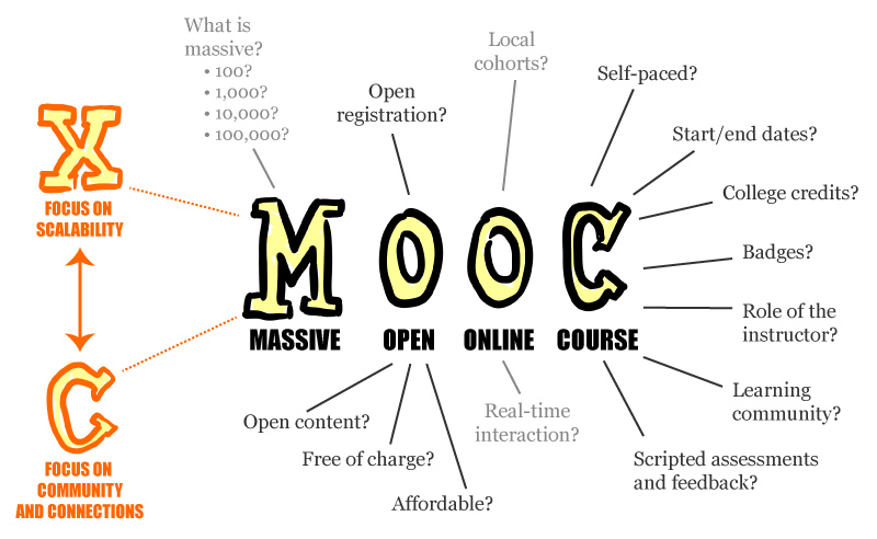
Explanation of the concept MOOC [source]
If you need more information about MOOC you can find a really good article on Wikipedia.
A list of good places from where you can learn
While there are countless of platforms which offer MOOCs, there are not that many that offer Geomatics or Geospatial related courses. They are also quite scattered around the web which is why I compiled a short list of platforms that currently offer such courses so that you don’t waste too much time looking for them.
Moreover, there are online aggregators such as Class Central or MOOC List that can help you search search courses that you could potentially be interested in. Just try looking them up using all sorts of tags such as “GIS”, “geospatial”, “Mapping”, “Geography”, “location” etc.
Keep an eye on these platforms as in the future other courses related to Geomatics/Geospatial might be launched so feel free to create an account and get notified.
But which one should I pick first?
When you will first check out the websites I pointed you to you’ll probably find one huge collection of courses from various institutions covering an impressive amount of subjects. Even though you might be curious to check out courses other than GIS related you might benefit from reading some of the tips below.
#1 Start small
In the beginning it’s crucial that you start with reasonable objectives, lower aims and with the idea that you should have fun while learning. You’ll occasionally run into bumps but don’t let that discourage you. As long as you don’t set your goals too far ahead and focus on what you are doing then you’re going to make it.
One suggestion is that you start by taking shorter courses that don’t require you to work too many hours per week especially when you are not familiar with a topic. After a while you might be comfortable sustaining more effort per week.
#2 Structure your learning
While all MOOCs offer a description of how the course is set up and what are the recommendations on how to turn your experience into a successful one, it’s really important you first figure your own way of learning.
This is really important, while you might think to consider that scheduling courses like you had in university was something you weren’t necessarily in favor of, in order to learn correctly you need a structure so that you can learn step by step. Secondly, in time you will become more efficient if you follow a path with clear and reasonable goals within your time management skills.
Selection of interesting courses
GIS fundamentals & advanced
Esri MOOC – One of the first places you should go if you want to learn more about Esri technologies and some general GIS techniques is of course the Esri MOOCs. Personally, I have tried 3 of them and had a pleasant experience, the material is offered as short videos completed by various labs where you try to solve some problems. At this point the courses revolve around ArcGIS Online platform.
GIS specialization – while for those who already had a couple of classes in GIS it might not be the kind of advance course you were looking for you might still find some use for them. If you’re still learning you might give them a try, it won’t really cost you anything else than some time.
Data visualization
Data visualization and D3.js – this is an opportunity to learn how to better present your analysis. D3 is quite a popular library for data visualization, including geospatial data.
Google Maps API – an introductory course about using the API to work with location features, how to embedd a map visualization to a website and so on.
Programming
When you start to learn programming you will soon enough find the need to make progress fast and pick a really popular language and so on. Do your best to resist that temptation. First focus on getting the basics, understand how to use the concepts correctly through exercises, then do some mini-projects then you can start working out some ideas that will help you explore different areas.
Using Python to Access Web Data and Using Databases with Python – if you found yourself in the need of using Python for scrapping data from the web, parse it, store it in relational databases and then visualize, then these courses are for you.
Object Oriented Programming in Java – This course is a real treat for those working with maps and data visualization that have a basic programming knowledge. You will have the chance to learn Object-Oriented Programming in Java while developing small applications each week eventually leading to one final application as a result.
Note: At the the time I wrote this article all of these resources are offered for free, except for Udemy platform where some courses are only accessible by paying, and the cases where you want a certificate/statement of accomplishment you might have to pay.


Hi, good place where you can learn Java https://codegym.cc/