
Geomatics Correcting a Critical Survey Error on the Canada US border
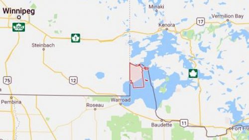
A petition on the White House Website is asking for a 320-square kilometre parcel of land in Minnesota called the Northwest Angle to be returned to Canada—where, apparently, it actually belongs. The anonymous petitioner says that Angle Township is part of Canadian township according to original agreements between Britain and Canada, until this was overlooked on an inaccurate map created in 1755 by John Mitchell that was used by the fathers of confederation. The petition requires 100,000 signatures before January 29th in order to receive a response.
RADARSAT delayed again
The RADARSAT Constellation Mission (RCM) scheduled for launch in mid-February has experienced another delay after the soft ocean landing of the Falcon 9 rocket first stage booster. CEO of SpaceX Elon Musk says that a “grid fin hydraulic pump stalled, so Falcon landed just out to sea. Appears to be undamaged & is transmitting data. Recovery ship dispatched.” The result is a scheduling conflict for MDA (who procured the launch) and SpaceX; no solution or relaunch date has yet been announced.
Remapping mountains, step by step
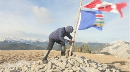
Gérard Lachapelle is rewriting topographical maps of hiking paths in Kananaskis and Banff by hiking them himself. Combining his love of hiking with his expertise in geomatics, the professor emeritus of the University of Calgary has so far measured roughly 15 mountains and observed that most maps are accurate within 10 to 20 metres. Cascade Mountain near Banff was previously recorded at 2,998 metres while Lachapelle measured it at 3,006, and others, like Ha Ling Peak in Canmore, were off by much more. The data he collects with GPS he shares with Natural Resources Canada so changes can be made to official topographical data.
Sidewalk Labs hits the streets in Thorncliffe Park
Sidewalk Labs is at last ready to make its presentation to the Digital Strategy Advisory Panel of Waterfront Toronto, and briefing documents show that the company is already experimenting with data in Toronto to see just how residents use public space. Using an app developed by Sidewalk called CommonSpace, volunteers used geospatial systems to gather data, but trouble arose when Sidewalk Labs appeared to violate its own proposal for urban data collection standards by failing to publish a Responsible Data Impact Assessment, therefore putting transparency into question. Nevertheless, Sidewalk Labs is planning an exhibit on the project at its public showroom at 307 Lakeshore Boulevard East in the Quayside neighborhood.
Virtual objects & game-based learning
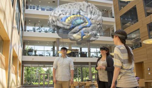
UBC’s Emerging Media Lab is collaborating with students at Microsoft Vancouver’s Garage Internship Program to blend 3D virtual content and 2D MRI scans to open up a new window into the brain’s inner architecture: the HoloBrain. The HoloBrain responds to the hand gestures and voice commands of medical students wearing HoloLens headset projects. The HoloBrain is intended to complement in-lab dissections, and Dr. Claudia Krebs—a senior instructor at the department of cellular and physiological sciences at UBC’s faculty of medicine—says of VR in general: “We’re very excited to be introducing the world of mixed reality into the classroom, and we’re looking forward to adding to our existing tools in collaboration with researchers across campus.”


Be the first to comment