
Mayor Jim Watson to open GeoIgnite 2019 
GeoIgnite is excited to announce that Mayor Jim Watson will be introducing the plenary day of GeoIgnite 2019! As the new national conference is taking place in Canada’s capital, it’s apropos that the Mayor should open the festivities—but more than that, it’s a sign that Mayor Watson is supporting Ottawa’s status as a major tech hub, and helping to fuel jobs, innovation and interconnectivity between the industry and government at the municipal and federal level.
Updated flood maps pose problems for the housing industry
In the next year, the federal government plans to upload up to 2000 floodplain maps with the most up-to-date geospatial data—and according to Neil Macdonald, it will have a devastating effect on the housing market. The Ottawa River has flooded twice in the last three years, and many prospective homeowners are for the first time checking to see if properties are at risk before they buy. They will benefit from maps that will eventually identify whole communities as at risk for flooding, drastically affecting property values and flood insurance premiums. The insurance industry wants to push for flood-proofing and the reassessment of premiums, and Macdonald says that new, updated maps will give justification to either dramatically hike premiums for some homeowners or refuse them insurance entirely.
RADARSAT launching from Vandenberg, California
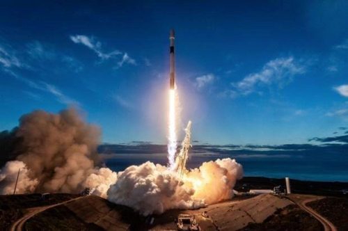
The RADARSAT Constellation Mission satellites are scheduled to launch at the end of this month (or early June) aboard the SpaceX Falcon 9 rocket from the Vandenberg Air Force Base in California. The three-satellite configuration provides daily revisits of Canada’s territory, four passes per day in Canada’s far north and several passes per day over the Northwest Passage, plus daily access to 90% of the world’s surface up to four times a day. The RCM has a robust and flexible system that will provide affective solutions for maritime surveillance, disaster management, and ecosystem monitoring. RCM data will have many different applications for the public and private sections. The constellation model allows for more visits of the same area, providing a regular collection of data for land use evolution, coastal change, urban subsidence and even human impacts on local environments.
Maxar tests their Hub under DARPA
Maxar Technologies is testing its Geospatial Cloud Analytics Hub under a $4.3M contract with the Defense Advanced Research Projects Agency (DARPA). Maxar has said that the GCA Hub is an unclassified platform designed to help military users produce information about the planet through machine learning. Maxar will offer technical support as 10 technical area and 2 expert providers work to develop and train machine learning models in the GCA Hub. Tony Frazier, executive vice president of Maxar’s global field operations said: “Maxar is proud that DARPA selected its GCA Hub for the testing phase of this program, demonstrating that solutions can be made faster for the end user when government harnesses commercial innovation.”


Be the first to comment