
NRCan empowers citizen scientists during floods

When Canadian communities are hit hard by flooding, Vincent Decker’s team of scientists at Natural Resources Canada (NRCan) provide first responders and decision makers with the data they need to deal with crises through semi-automated radar satellite imagery processing techniques that produce flood-mapping imagery. Now they are encouraging citizen scientists to provide data for the same purpose by creating an app that will allow anyone with a smart phone to upload data to an AI that will generate on-the-scene imagery to improve flood map accuracy. The app is part of a push to improve the usability of satellite imagery for real-world problems using people in real situations.
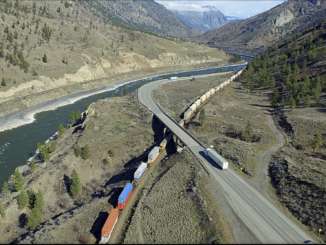
Prince Albert Satellite Station is an asset to national and international data collection
The Prince Albert Satellite Station is a major operation that benefits global GIS. The station gives Environment Canada the ability to observe a number of data sets, including oil spills, crop health, forest fires and the impacts of climate change. But the information isn’t only used in Canada: partners around the world share the information, and the Prince Albert station monitored at least 14 major global events in 2017. Updated multiple times over the years to adapt to advancing technology, the station’s current upgrades will last until 2035 and continue to collect data from as far away as Greenland and Mexico. As the station makes is important asset not only for Canada but the community the local Prince Alberta community wrote about it.
Vancouver’s Urthecast approved for US$142 million credit
UrtheCast is a Vancouver-based Canadian Earth Observation company. Urthecast secured an impressive $142 million credit to construct, launch and deploy six satellites. The sixteen multispectral optical and SAR satellites, called OptiSAR, will form the “UrtheDaily Constellation”. Urthecast has also signed binding data subscription contracts for the UrtheDaily Constellation totaling more than $100 million over the duration of the contracts, hoping that the long-term revenue from anchor customers will provide a consistent revenue stream for up to seven years. The question is, will the available credit be enough to help Urthecast reach its ambitious goals?
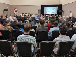
SAIT Geomatics Students writes open letter to GoGeomatics on Importance of Socials

Michael Zacher was a faithful attendee of the Calgary GoGeomatics Back to School socials, and after securing a job opportunity at the last Back to School Social in Calgary has written about the experience:
“I encourage anyone seeking employment, looking to further their career, or simply wanting to discuss new and current technologies within their industry to make the effort to attend as many of these (GoGeomatics) networking events as possible.”
Taking part in a GoGeomatics social gives you instant access to a professional network, opportunities to volunteer, and the wider GIS community in Canada.
Ottawa Company continues to make its mark on the GIS market
CarteNav has selected Konsberg Geospatial’s TerraLens platform as the engine for its next generation of Mission system software AIMS. A leader in mission system software, CarteNav selected the TerraLens platform based on the quality of Konsberg’s product, the company’s track record in GIS, and their on-site support. According to CartNav Solutions president Paul Evans: “By using TerraLens, we expect to be able to offer even better performance capabilities in the next generation of our AIMS software products.”
GIS aids archeological survey of Simcoe County
The County of Simcoe is developing a GIS-based map that identifies areas of Indigenous and colonial archeological potential as part of an Archeological Management Plan. The mapping will aid in conserving the county’s cultural heritage, particularly that of First Nations and Metis communities, and be valuable to the creation of contingency plans and land use policy for future generations.

Be the first to comment