
AI and Facial Recognition, a Geoprivacy Issue
More and more, people associated facial recognition technology with privacy issues. However, few think of it as a geoprivacy issue. With most photos now timestamped and geotagged, our digital footprint becomes more detailed than ever. By combining facial recognition and image timestamps/geotags, we can now easily link who the person is to where they are and when.
In December 2019, a news article from New York Times discussed how “Clearview AI purports to have a database of 3 billion photos scraped from YouTube, Venmo, Facebook, and others, offering additional information such as names and locations from the source captions of the photos”. The technology is marketed to law enforcement. This service has been purchased thus far by the Indiana State Police and the Gainesville Police.
The images in the Clearview AI database have been collected from a variety of sources, and this collection does violate some of the terms of service of these companies. There is however a way to remove yourself from the Clearview database directly, but it does have a few people raising eyebrows… you will need to send a headshot of yourself along with a photo of your government ID.
As awareness grows, so does the backlash. Twitter sent a cease-and-desist letter, and Facebook paid a “$550 million settlement in Illinois for violating the state’s biometric privacy law with its facial recognition photo tagging”. Let’s continue to raise awareness and increase legislation around geoprivacy.
Clearview AI and Facial Recognition as a Geoprivacy Issue
Velodyne releases $100 lidar sensor
With the popularity of autonomous vehicles growing, a growing concern becomes the cost of the technology. However, Velodyne’s latest sensor is an “optimal automotive-grade lidar sensor for Advanced Driver Assistance Systems (ADAS)”, and is priced at only $100.
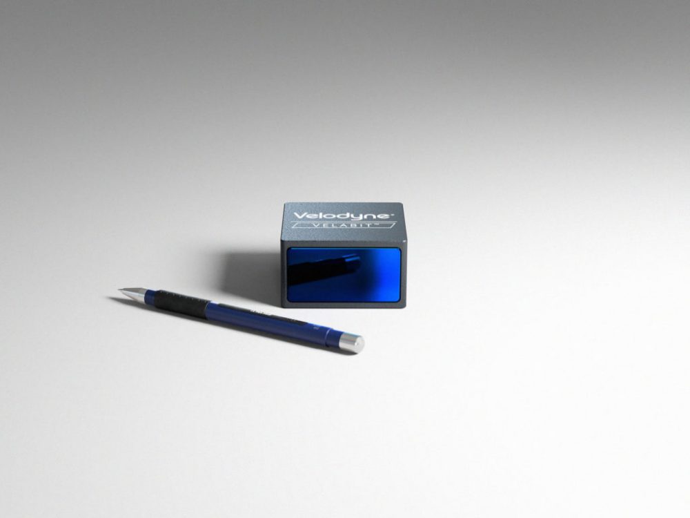
The product is small, versatile, and best of all, affordable. Combined with the company’s long distance Velarray sensor, this can be used for high-speed operation. With such innovation, we are looking forward to seeing the evolution the field.
Velodyne releases $100 lidar sensor
1st Annual QGIS Conference
April 3rd, 2020 at Cornell University in Ithaca, NY will mark the beginning of the 1st Annual QGIS Conference. This free event will be capped off at 50 people (51st will be waitlisted) and will begin at 8:30AM.
The proposed agenda is as follows;
(1) Registration
(2) Welcome / Overview of QGIS
(3) Morning Workshops
For beginners: loading different types of data into QGIS, basic visualization, vector functions
For advanced users: raster functions and spatial database management
(4) Lunch (included)
Vegan, vegetarian, gluten-free, and locally-produced options will be available
If applicable, seated with paired mentor or mentee
(5) Afternoon Presentations
Cartography
Online web mapping
Overview of some useful features
QGIS Plugins
(6) Panel Question and Answer Period
Respond to lingering questions of the day
Mentor-mentee program
(7) Closing remarks
Getting QGIS help and reporting issues
If you would like to register for this event, click here.
1st Annual QGIS Conference – April 3, 2020
The Coronavirus Map
As of January 23rd, 2020 there have been 555 cases of the Coronavirus and 17 associated deaths.
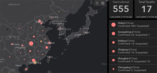
The Wuhan Coronavirus (2019-nCoV) Global Cases developed an interactive map to show the confirmed cases around the world. It is updated daily by using the data collected by the World Health Organization, the Center for Disease Control and the National Health Committee of the People’s Republic of China.
To view news about the Coronavirus update, visit the HealthMap.


Be the first to comment