
New online master’s degree in spatial data science
Pennsylvania State University has launched a new online master’s degree in spatial data science. Starting January 2021, the program is designed to arm students with skills to interpret and analyze location data which has become more and more important for companies.
https://edscoop.com/penn-state-online-masters-degree-spacial-data-science/
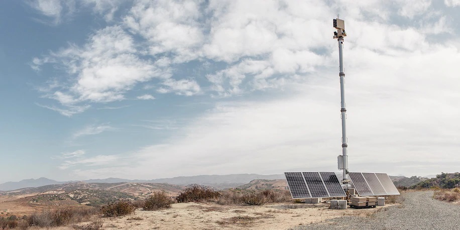
Trump administration builds high-tech virtual wall instead of concrete wall
A Californian start-up has been awarded a contract which deploys hundreds of solar-powered mobile surveillance towers to serve the purpose of virtual walls along the border. The towers, equipped with camera and thermal imaging, detect moving objects and send location information to the cellphones of U.S. agents.
The tower system will be more effective in isolated area where illegal crossings are less prominent. Smart border technology can be more efficient than walls just made of steel and concrete.
The SMU Professor Who Explodes Indiana Jones
“Maps are for us. No other creature needs them. They are the way we humans make the world legible for ourselves” said Mark D. McCoy, a geospatial archaeologist and professor at SMU.
His new book, Maps for Time Travelers: How Archaeologists Use Technology to Bring Us Closer to the Past, explains how satellite imagery and 3D modeling help archaeologists answer questions about our past

Pinpointing locations of reusable materials for road construction
As Dura Vermeer, a Dutch construction infrastructure company, reuses recycled asphalt to pave roads, they leverage geo-data to ensure the recycled materials do not come from older roads. The company looks for tar which was banned from roads in the Netherlands since 1991.
New technologies have also been introduced to monitor the conditions of roads and make sure damages can be repaired in time.
https://www.geospatialworld.net/blogs/pinpointing-the-locations-of-reusable-materials/


Be the first to comment