
Between the Poles – The Geoff Zeiss Archives
Dubai
Map Middle East 2006 was held this year in Dubai, which I discovered is one of the most remarkable places in the world. First of all it has literally risen out of the desert in […]
Map Middle East 2006 was held this year in Dubai, which I discovered is one of the most remarkable places in the world. First of all it has literally risen out of the desert in […]
Since Monday I’ve been at Map Middle East 2006 in Dubai. There are people here from several parts of the world, but primarily from the Middle East as you might expect. Some very interesting themes […]
March 7, 2006 was a big day for the geospatial community, because that was when Bob Bray, MapGuide Technical Architect at Autodesk, hit the switch that released MapGuide Open Source to the Open Source Geospatial […]
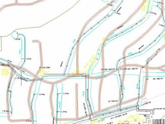
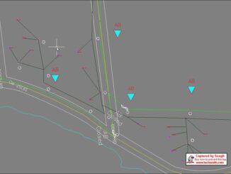
Landbase evolution One of the problems that just about every organization responsible for managing network infrastructure has to face is the evolution of its landbase. By the landbase I mean maps of the roads, water […]
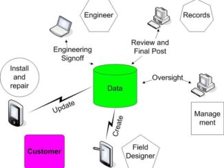
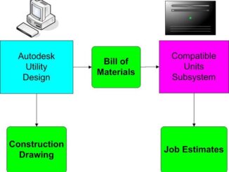
Models and Intelligent Databases A key concept that characterizes next generation design tools is model-driven design. First generation CAD tools were designed to produce pieces of paper, called construction drawings in the case of telco, […]
Up until a year ago the only handheld alternatives that utilities and telcos had for their field staff were either PDAs or notebooks such as Panasonic Toughbooks. PDAs PDAs, while fine for tabular information, simply […]

2005 Report Card on America’s Infrastructure The American Society of Civil Engineers (ASCE) publishes a biennial report card on the condition of US infrastructure including roads. In 2001 ASCE assigned a grade of D+ to […]
At the recent Eastern Utility Forum one of the critical areas that was identified by participants, which included power, gas, and railroad companies, is the aging workforce. This is a bigger problem for utilities than […]