• facebook
  • Twitter
  • Linkedin
  • Youtube
  • Linkedin Group
  • Post a Job
  • Post an Ad
  • Post an Event
  • Post a Directory Listing
  • Post a Press Release
  • Media Kit
  • My Account
  • Login
GoGeomatics
  • MAGAZINE
    • BIM & GIS
    • Community
    • Conference news
    • Earth Observation
    • Education & Careers
    • GEOAI
    • Announcements
    • Reality Capture & Lidar
    • Science
    • Technology
    • Between the Poles
  • Directories
    • ASSOCIATION
    • INDUSTRY
    • EDUCATION
    • Open Data
  • EVENTS
    • GeoIgnite Events
    • Events Calendar
    • GoGeomatics Meetups
  • Services
    • Advertising
    • Marketing
    • Post a Job
    • Post an Ad
    • Post an Event
    • Post a Press Release
    • Post a Directory Listing
    • Media Kit
    • Web Design
  • Find a Job
  • Volunteer
    • Start a GoGeomatics Group
    • Editors & Writers Group
  • About Us
    • About Us
    • Contact Us
    • Frequently Asked Questions
  • Videos
Home2006May

Month: May 2006

Between the Poles – The Geoff Zeiss Archives

Spatial Data Infrastructure- A Practical Example

29 May 2006 Geoff Zeiss

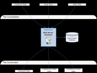
In my last blog I outlined some alternative architectures that a large organization could implement to share spatial information.  In this blog I would like to present a practical example of the spatial warehouse architecture […]

Between the Poles – The Geoff Zeiss Archives

Spatial Data Infrastructure for Government

20 May 2006 Geoff Zeiss

One of the scenarios that is becoming increasingly common especially in government at the national level is an IT solution for sharing data, often referred to as spatial data infrastructure or SDI.  In most organizations […]

Between the Poles – The Geoff Zeiss Archives

Integrating MapGuide Applications with Google Earth

11 May 2006 Geoff Zeiss

One of the neat things about MapGuide Open Source is that it is designed to make it very easy for you to build mashups. You’ve probably heard the term mashups, which refers to web applications […]

Between the Poles – The Geoff Zeiss Archives

Interoperability using Tightly and Loosely Coupled (SOA) Architectures

8 May 2006 Geoff Zeiss

One of the key trends of recent years is the integration of geospatial technology into mainstream IT. What this means practically is that standard IT architectures, tools, and standards are now being applied to geospatial […]

Events

Feb 16
February 16 @ 8:00 am - February 18 @ 5:00 pm

GeoWeek 2026

Feb 18
6:30 pm - 8:30 pm

Vancouver GoGeomatics Meetup – February 2026

Feb 19
February 19 - February 22

Spatial Knowledge and Information Canada 2026

Feb 19
February 19 - February 22

SKI Conference Canada 2026

Feb 23
7:00 pm - 9:00 pm

Toronto GoGeomatics Networking Social – February 23, 2026

View Calendar

View All Events

Services

  • Post a Job
  • Post an Ad
  • Post an Event
  • Post a Directory Listing
  • Post a Press Release
  • Media Kit
  • My Account
  • Login

Jobs

Post a Job
  • Volunteer Editorial Contributor – Be Part of Canada’s Geomatics Story
    Remote
  • Junior Geomatics Field Technician – Technical Surveys
    Montréal, QC
  • GIS Specialist
    Amherst, Nova Scotia
  • Precast Structural BIM Specialist
    Calgary, Alberta
View All Jobs
  • Directories
    • Associations Directory
    • Industry Directory
    • Education Programs
    • Open Data
  • Volunteer
    • Start a GoGeomatics Group
    • Editors & Writers Group
  • About Us
    • GoGeomatics Media Kit
    • Who We Are
    • Contact Us
    • FAQ’s
    • Advertising
    • Marketing
  • Subscribe
GoGeomatics
GoGeomatics is the largest and most popular communications hub promoting the Canadian geospatial community. The business was incorporated in 2011. GoGeomatics hosts over 100 fun, free, location technology networking events each year in cities across Canada.

© 2026 GoGeomatics

  • facebook
  • Twitter
  • Linkedin
  • Youtube
  • Linkedin Group