• facebook
  • Twitter
  • Linkedin
  • Youtube
  • Linkedin Group
  • Post a Job
  • Post an Ad
  • Post an Event
  • Post a Directory Listing
  • Post a Press Release
  • Media Kit
  • My Account
  • Login
GoGeomatics
  • MAGAZINE
    • BIM & GIS
    • Community
    • Conference news
    • Earth Observation
    • Education & Careers
    • GEOAI
    • Announcements
    • Reality Capture & Lidar
    • Science
    • Technology
    • Between the Poles
  • Directories
    • ASSOCIATION
    • INDUSTRY
    • EDUCATION
    • Open Data
  • EVENTS
    • GeoIgnite Events
    • Events Calendar
    • GoGeomatics Meetups
  • Services
    • Advertising
    • Marketing
    • Post a Job
    • Post an Ad
    • Post an Event
    • Post a Press Release
    • Post a Directory Listing
    • Media Kit
    • Web Design
  • Find a Job
  • Volunteer
    • Start a GoGeomatics Group
    • Editors & Writers Group
  • About Us
    • About Us
    • Contact Us
    • Frequently Asked Questions
  • Videos
Home2009May

Month: May 2009

Between the Poles – The Geoff Zeiss Archives

Open RESTful Architecture for Geospatial Data Web Services: Accessing Spatial Data with No Programming

30 May 2009 Geoff Zeiss

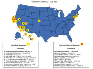
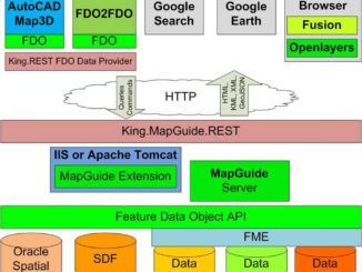
Recently the Free and Open Source Software Learning Centre (FOSSLC) held their annual Summercamp in Ottawa.  Haris Kurtagic and I prepared a presentation on a RESTful implementation of an open API for data access that […]

Between the Poles – The Geoff Zeiss Archives

Southern California Edison Tops Solar Power Capacity Ratings

29 May 2009 Geoff Zeiss

There’s an interesting article in Wired listing the top utilities in the US in 2008 for solar power generation.  It is really amazing how many of these are in California.  Southern California Edison, which provides […]

Between the Poles – The Geoff Zeiss Archives

Vancouver City Council Passes Motion Endorsing Open Data and Open Standards

29 May 2009 Geoff Zeiss

The City of Vancouver has passed a motion endorsing open data, open standards, and leveling the playing field for open source software procurement.  I had blogged about this earlier.

Between the Poles – The Geoff Zeiss Archives

Google Maps Creators Design Google Wave

29 May 2009 Geoff Zeiss

Google Wave was previewed at Google I/O.  According to one source, it is a combination of social networking, Gmail and Google Docs.  Google Wave was designed by the Rasmussen brothers (Lars and Jens) who founded […]

Between the Poles – The Geoff Zeiss Archives

AutoCAD Releases for Past 25+ Years

29 May 2009 Geoff Zeiss

I wasn’t aware of this site maintained by Shaan Hurley listing every release of AutoCAD and DWG starting with V1 in 1982.   Shaan has pictures related to many of the releases.  This is a […]

Between the Poles – The Geoff Zeiss Archives

Convergence of Design and Gaming: Stimulus Funds for Virtual Shovel-Ready Projects

28 May 2009 Geoff Zeiss

There is a fascinating news item on NPR radio about stimulus money going to virtual shovel-ready projects which is really worth listening to. Gaming Technology One of the things I like to mention when I’m […]

Between the Poles – The Geoff Zeiss Archives

North America Is a Wonderful Place to Live If You’re a Car: Is Mayor Bloomberg Going to Change This ?

24 May 2009 Geoff Zeiss

One of the things that strikes many visitors from Europe is the concrete and asphalt wasteland of many North American cities, which were built primarily with commerce in mind. Robert Moses of the Triborough Bridge […]

Between the Poles – The Geoff Zeiss Archives

Google Maps Data API Announced at Where 2.0

22 May 2009 Geoff Zeiss

At Where 2.0 Google annouced the Google Maps Data API which alows you to upload spatial data to Google.  The Maps Data API means your application can view, store and update map data on Google […]

Posts pagination

1 2 … 5 »

Events

Feb 16
February 16 @ 8:00 am - February 18 @ 5:00 pm

GeoWeek 2026

Feb 17
5:00 pm - 8:00 pm

Victoria GoGeomatics February Mappy Hour

Feb 17
6:00 pm - 8:00 pm

Calgary GoGeomatics February Social

Feb 18
6:30 pm - 8:30 pm

Vancouver GoGeomatics Meetup – February 2026

Feb 19
February 19 - February 22

Spatial Knowledge and Information Canada 2026

View Calendar

View All Events

Services

  • Post a Job
  • Post an Ad
  • Post an Event
  • Post a Directory Listing
  • Post a Press Release
  • Media Kit
  • My Account
  • Login

Jobs

Post a Job
  • Volunteer Editorial Contributor – Be Part of Canada’s Geomatics Story
    Remote
  • Junior Geomatics Field Technician – Technical Surveys
    Montréal, QC
  • GIS Specialist
    Amherst, Nova Scotia
  • Precast Structural BIM Specialist
    Calgary, Alberta
View All Jobs
  • Directories
    • Associations Directory
    • Industry Directory
    • Education Programs
    • Open Data
  • Volunteer
    • Start a GoGeomatics Group
    • Editors & Writers Group
  • About Us
    • GoGeomatics Media Kit
    • Who We Are
    • Contact Us
    • FAQ’s
    • Advertising
    • Marketing
  • Subscribe
GoGeomatics
GoGeomatics is the largest and most popular communications hub promoting the Canadian geospatial community. The business was incorporated in 2011. GoGeomatics hosts over 100 fun, free, location technology networking events each year in cities across Canada.

© 2026 GoGeomatics

  • facebook
  • Twitter
  • Linkedin
  • Youtube
  • Linkedin Group