Engineering Data to GIS and Back
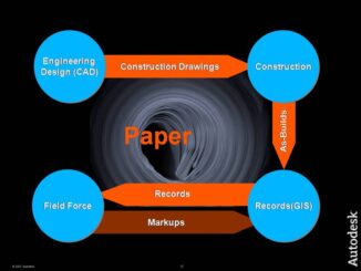
Most of the world’s vector spatial data is captured using CAD desktop applications, whether we are talking about engineering design data or traditional geospatial data. Over the past 20 or so years most of the […]
At GITA last week I ran into Steve Serra from Oracle who updated me on open source support for Oracle Spatial/Locator. He provided a site where open source products supporting Oracle Spatial are listed. The […]
WAURISA was kicked off by a very interesting presentation by Cy Smith, Oregon Geographic Information Officer (OGIO) and Past President of the National States Geographic Information Council (NSGIC). He outlined the NSGIC strategic framework for […]
MSNBC and Moody’s have computed what they call an Adversity Index which attempts to measure the economic health of 381 metro areas and all 50 states and assign an economic health quotient, according to whether […]
Kansas State University Geography has calculated quotients for the seven deadly sins for each county (I’m guessing) in the US and plotted the results as maps. Plenty of material here for blaming some other part of […]
A recent post by Dale Lutz of Safe Software reminded me that one of my fellow directors on the GITA Board is Eric Hoogenraad, of the City of Abbotsford, whose title is Manager of Geomatics and Building […]
I’m at WAURISA in Bellevue, WA for a geospatial conference for a few days. The first day is devoted to workshops. The Open Source Geospatial Foundation (OSGeo) presented an introduction to open source geospatial applications […]
Last week after Map Middle East we drove from Abu Dhabi to Dubai, where I spent the day with some of our partners. This was the first time I had been in Dubai since the […]