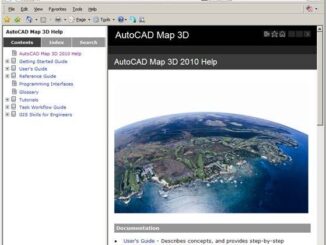
AutoCAD Map 3D Documentation Now on the Web
There is now a Web-based version of AutoCAD Map 3D Help which is available on the Autodesk Web site. This means that users who use Google to search for answers will now find results from […]
There’s a very interesting article about two bills recently introduced by the Conservative government, the Investigative Powers for the 21st Century Act and the Technical Assistance for Law Enforcement in the 21st Century Act, which […]
There is an worthwhile article in Cadalyst by Marcia Carillo which reports on a return on investment (ROI) analysis comparing AutoCAD, a pure CAD platform, to AutoCAD Map 3D, a data-management and interoperability platform. To do this you […]
Last September I blogged about North Shore City, a municipality in New Zealand, that has made maps of its water, waste water and storm water network infrastructure publically available on the web. Not only is the […]
The proposed bill will require governmental agencies in Texas, such as appraisal districts, that provide geospatial and mapping products to the public that include property boundaries to include a disclaimer if the proporty boundaries are […]
Some encouraging feedback from Zac Spitzer about MapGuide Open Source 2.1 Beta “I have been doing some heavy testing on this release over the weekend and it’s easily the most stable MapGuide Release to date! […]
According to the CBC, a Merivale Road Shell station in Ottawa is selling fuel comprised of 90% gasoline and 10% cellulosic ethanol. The ethanol is produced locally at Iogen Energy’s demonstration plant in which Royal […]
Last year the World Bank introduced the concept of Eco2 cities which is designed to combine both ecological and economic development. In the past economic development, especially rapid economic development, has been associated with rampant […]