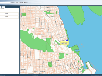
New NanaimoMap Beta Uses MapGuide Open Source
The City of Nanaimo launched their new MapGuide Open Source / Fusion based NanaimoMap in beta in July. It’s in beta to shake out issues by more widespread use, and because they have not yet […]
Jackie Ng has announced the latest release of the FDO Toolbox. Monochromatic map previews are a thing of the past. The Toolbox also now provides basic spatial indexing for datasets. Because this enables doing intersection […]
As I blogged previously, the extent of Arctic sea ice is one of the most accessible sources of data showing the effect of global climate change. The National Snow and Ice Data Center (NSIDC) began […]
AutoCAD Map 3D 2010 Update 1 has been released.
Autodesk has announced SketchBook Mobile, an app for the Apple iPhone and iPod Touch. SketchBook Mobile is a professional-level paint and drawing application designed for illustrators and artists. It will be available on the iPhone […]
Imaginit is sponsoring an event, in Toronto, Vancouver, and Halifax at the end of September and beginning of October, dedicated to one of most widespread issues affecting the reliability of infrastructure data. Mike Schlosser will be talking […]
I blogged earlier about the series of articles by Terry Bennett that talks about sustainability from a civil engineering perspective and assesses the impact of building information modeling (BIM). In the second part of his series […]
I blogged earlier about Vancouver’s committment to open data, open standards, and open source. The City is committed to freely sharing its data in accessible formats and has just opened their Open Data Catalogue Beta, Vancouver’s data.gov, […]