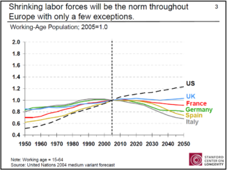
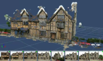
• facebook
  • Twitter
  • Linkedin
  • Youtube
  • Linkedin Group
  • Post a Job
  • Post an Ad
  • Post an Event
  • Post a Directory Listing
  • Post a Press Release
  • Media Kit
  • My Account
  • Login
GoGeomatics
  • MAGAZINE
    • BIM & GIS
    • Community
    • Conference news
    • Earth Observation
    • Education & Careers
    • GEOAI
    • Announcements
    • Reality Capture & Lidar
    • Science
    • Technology
    • Between the Poles
  • Directories
    • ASSOCIATION
    • INDUSTRY
    • EDUCATION
    • Open Data
  • EVENTS
    • GeoIgnite Events
    • Events Calendar
    • GoGeomatics Meetups
  • Services
    • Advertising
    • Marketing
    • Post a Job
    • Post an Ad
    • Post an Event
    • Post a Press Release
    • Post a Directory Listing
    • Media Kit
    • Web Design
  • Find a Job
  • Volunteer
    • Start a GoGeomatics Group
    • Editors & Writers Group
  • About Us
    • About Us
    • Contact Us
    • Frequently Asked Questions
  • Videos
Home2010

Year: 2010

3D Visualization

3D Models with a Digital Camera

13 October 2010 Geoff Zeiss

Project Photofly is a technology preview of a web service that allows you to convert digital photographs taken with a consumer digital camera into a 3D image (point cloud).  You take pictures around the object […]

Dan Eslinger of NavCom Technology Inc
Education & Careers

Manager Software Engineering

10 October 2010 Jon Murphy | AB

Dan Eslinger of NavCom Technology Inc was kind enough to talk with GoGeomatics to help better explain and define what a Manager Software Engineering role could be. […]

3D Visualization

3D Is Helping Address the Aging Workforce Challenge

8 October 2010 Geoff Zeiss

One of my takeaways from the annual GITA ANZ 2010 conference in Brisbane earlier this year was from Graeme Anthonsen’s presentation in which he outlined the cadet program that City West Water has implemented to […]

Between the Poles – The Geoff Zeiss Archives

Green Power and Smart Grid in Ontario – How Is It Being Financed ?

6 October 2010 Geoff Zeiss

As I have blogged on several occasions Ontario is in several ways leading the charge in the green power/smart grid revolution in North America. Ontario’s roll-out of smart meters together with time-of-use electric power rates […]

Between the Poles – The Geoff Zeiss Archives

Standard Specifications and Drawings for Municipal Construction Projects and Data Quality

5 October 2010 Geoff Zeiss

I have blogged in the past (here, here, here and here) about the poor data quality of utility records databases that has serious implications.  It can lead to  such things as unreliable reports prepared for management and […]

Between the Poles – The Geoff Zeiss Archives

FGDC US Address Standard Nears Completion

4 October 2010 Geoff Zeiss

In 2005 URISA petitioned the Federal Geographic Data Committee to allow it to develop a standard for addresses in the US.  The petition was granted and the project to develope the United States Thoroughfare, Landmark, […]

Access to Spatial Data

Proposed OGC Standard for Geosynchronization

4 October 2010 Geoff Zeiss

One of the talks I attended at the URISA conference last week in Orlando was presented by Raj Singh of the Open Geospatial Consortium (OGC) on the subject of “geosynchronization”.  This has nothing to do […]

Between the Poles – The Geoff Zeiss Archives

BIM Recommended for UK Government Procurement

4 October 2010 Geoff Zeiss

The chief construction adviser to the UK Government has said that Building Information Modelling (BIM) will become a part of the procurement of public buildings in the UK and indicated that bidders and contractors on […]

Posts pagination

« 1 2 3 4 … 26 »

Events

Apr 27
April 27 - April 30

Welcome to the Canadian Hydrographic Conference 2026

May 3
May 3 @ 8:00 am - May 6 @ 5:00 pm

GEOINT Symposium 2026

May 11
May 11 @ 8:00 am - May 13 @ 5:00 pm

GeoIgnite 2026

May 25
May 25 - May 28

National Surveyors’ Conference 2026

May 27
May 27 @ 8:00 am - May 29 @ 5:00 pm

Canadian Cartographic Association Conference 2026

View Calendar

View All Events

Services

  • Post a Job
  • Post an Ad
  • Post an Event
  • Post a Directory Listing
  • Post a Press Release
  • Media Kit
  • My Account
  • Login

Jobs

Post a Job
  • Operations Spatial Data Assistant (Contract)
    Vaughan
  • GIS Analyst
    Saint John, New Brunswick
  • GIS Student Intern
    Elmsdale, Nova Scotia
  • Canada Impact+ Research Chair – Professor (Or Associate Professor)
    Lethbridge, Alberta
View All Jobs
  • Directories
    • Associations Directory
    • Industry Directory
    • Education Programs
    • Open Data
  • Volunteer
    • Start a GoGeomatics Group
    • Editors & Writers Group
  • About Us
    • GoGeomatics Media Kit
    • Who We Are
    • Contact Us
    • FAQ’s
    • Advertising
    • Marketing
  • Subscribe
GoGeomatics
GoGeomatics is the largest and most popular communications hub promoting the Canadian geospatial community. The business was incorporated in 2011. GoGeomatics hosts over 100 fun, free, location technology networking events each year in cities across Canada.

© 2026 GoGeomatics

  • facebook
  • Twitter
  • Linkedin
  • Youtube
  • Linkedin Group