• facebook
  • Twitter
  • Linkedin
  • Youtube
  • Linkedin Group
  • Post a Job
  • Post an Ad
  • Post an Event
  • Post a Directory Listing
  • Post a Press Release
  • Media Kit
  • My Account
  • Shopping Cart
  • Login
GoGeomatics
  • MAGAZINE
    • BIM & GIS
    • Community
    • Conference news
    • Earth Observation
    • Education & Careers
    • GEOAI
    • Announcements
    • Reality Capture & Lidar
    • Science
    • Technology
    • Between the Poles
  • Directories
    • ASSOCIATION
    • INDUSTRY
    • EDUCATION
    • Open Data
  • EVENTS
    • GeoIgnite Events
    • Events Calendar
    • GoGeomatics Meetups
  • Services
    • Advertising
    • Marketing
    • Post a Job
    • Post an Ad
    • Post an Event
    • Post a Press Release
    • Post a Directory Listing
    • Media Kit
    • Web Design
  • Find a Job
  • Volunteer
    • Start a GoGeomatics Group
    • Editors & Writers Group
  • About Us
    • About Us
    • Contact Us
    • Frequently Asked Questions
  • Videos
Home2011August

Month: August 2011

3D Visualization

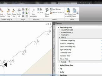
BIM for Infrastructure: Autodesk Announces AutoCAD Utility Design

9 August 2011 Geoff Zeiss

Autodesk has announced AutoCAD Utility Design 2012 (AUD), a model-based design solution for electric utility distribution networks.  AUD integrates a rules engine into the AutoCAD Map 3D environment and includes an electric distribution data model […]

3D Visualization

BIM for Infrastructure: Autodesk Announces New Conceptual Design Software

9 August 2011 Geoff Zeiss

Autodesk has announced new software for conceptual design as part of its BIM for Infrastructure portfolio.  Autodesk Infrastructure Modeler 2012 is designed for GIS, planning, and civil engineering professionals to help evaluate future infrastructure designs.  […]

No Picture
Access to Spatial Data

ACLU investigating how mobile phone geolocation data is being used for law enforcement in 31 states

7 August 2011 Geoff Zeiss

I remember a few months ago that it was headline news when it was revealed that Apple iPhones were retaining geolocation information that could be used to track users location.  Last week, American Civil Liberties […]

Between the Poles – The Geoff Zeiss Archives

Aug 6, 1991 the world’s first web site

7 August 2011 Geoff Zeiss

August 6, 1991, at a CERN facility in Switzerland, the first web site Info.cern.ch began running on a NeXT computer.

Between the Poles – The Geoff Zeiss Archives

Demand response: FERC rules that a negawatt-hour must be compensated the same as a megawatt-hour

7 August 2011 Geoff Zeiss

In March 2011, the Federal Energy Regulatory Commission (FERC) in Order No. 745, ruled that demand response, in other words paying for reducing power demand, must be compensated at the same rate as power generation, […]

Between the Poles – The Geoff Zeiss Archives

Californians continue to support state’s renewable energy objectives

7 August 2011 Geoff Zeiss

A new survey of Californians’ attitudes on the environment has been released by the Public Policy Institute of California (PPIC). Renewable energy California’s Renewable Portfolio Standard (RPS) policy requires that one-third of the state’s electricity […]

Between the Poles – The Geoff Zeiss Archives

Toward a US national transmission grid for renewable energy

7 August 2011 Geoff Zeiss

Estimates of the transmission buildout required in the US to bring renewable electric power to market have ranged from 19,000 to 50,000 miles of new transmission lines.  The Brattle Group has estimated the total investment […]

Posts pagination

« 1 2 3

Events

Sep 15
September 15 - September 17

INTERGEO 2026

Sep 16
September 16 - September 17

Join ALL IN 2026, Montreal, Canada

Oct 26
October 26 - October 28

Canada’s National Geomatics Expo 2026

Oct 27
October 27 - October 29

Rendez-vous Géomatique 2026

View Calendar

View All Events

Services

  • Post a Job
  • Post an Ad
  • Post an Event
  • Post a Directory Listing
  • Post a Press Release
  • Media Kit
  • My Account
  • Shopping Cart
  • Login

Jobs

Post a Job
  • Cartographic Analytical Technician / Technicien, analyses cartographiques; technicienne, analyses cartographiques
    Peterborough
  • Survey Technicians (Field and Office)
    Calgary, Alberta
  • Volunteer Editorial Contributor – Be Part of Canada’s Geomatics Story
    Remote
  • Construction Survey Technician/Technologist
    Britich Columbia
View All Jobs
  • Directories
    • Associations Directory
    • Industry Directory
    • Education Programs
    • Open Data
  • Volunteer
    • Start a GoGeomatics Group
    • Editors & Writers Group
  • About Us
    • GoGeomatics Media Kit
    • Who We Are
    • Contact Us
    • FAQ’s
    • Advertising
    • Marketing
  • Subscribe
GoGeomatics
GoGeomatics is the largest and most popular communications hub promoting the Canadian geospatial community. The business was incorporated in 2011. GoGeomatics hosts over 100 fun, free, location technology networking events each year in cities across Canada.

© 2026 GoGeomatics

  • facebook
  • Twitter
  • Linkedin
  • Youtube
  • Linkedin Group