• facebook
  • Twitter
  • Linkedin
  • Youtube
  • Linkedin Group
  • Post a Job
  • Post an Ad
  • Post an Event
  • Post a Directory Listing
  • Post a Press Release
  • Media Kit
  • My Account
  • Login
GoGeomatics
  • MAGAZINE
    • BIM & GIS
    • Community
    • Conference news
    • Earth Observation
    • Education & Careers
    • GEOAI
    • Announcements
    • Reality Capture & Lidar
    • Science
    • Technology
    • Between the Poles
  • Directories
    • ASSOCIATION
    • INDUSTRY
    • EDUCATION
    • Open Data
  • EVENTS
    • GeoIgnite Events
    • Events Calendar
    • GoGeomatics Meetups
  • Services
    • Advertising
    • Marketing
    • Post a Job
    • Post an Ad
    • Post an Event
    • Post a Press Release
    • Post a Directory Listing
    • Media Kit
    • Web Design
  • Find a Job
  • Volunteer
    • Start a GoGeomatics Group
    • Editors & Writers Group
  • About Us
    • About Us
    • Contact Us
    • Frequently Asked Questions
  • Videos
Home2011October

Month: October 2011

Between the Poles – The Geoff Zeiss Archives

Replacement of coal by gas for power generation accelerating in the US

26 October 2011 Geoff Zeiss

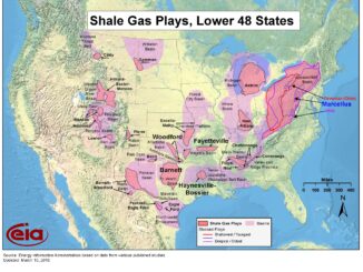
As I have blogged about before, shale-gas has transformed the energy market, especially for electric power generation in the U.S.  As a result of more efficient gas generation specifically combined cycle gas turbine technology and […]

Between the Poles – The Geoff Zeiss Archives

EPA plans to develop national standards for disposal of waste water from shale gas fracking

23 October 2011 Geoff Zeiss

I blogged recently about some of the issues around shale gas extraction using hydraulic fracturing (fracking).  In the last year the U.S. Environmental Protection Agency (EPA) has undertaken to study the impact of shale gas […]

Between the Poles – The Geoff Zeiss Archives

New ASTER global digital elevation model

23 October 2011 Geoff Zeiss

In 2009 NASA and the Japanese Ministry of Economy, Trade, and Industry (METI) released the Advanced Spaceborne Thermal Emission and Reflection Radiometer (ASTER) global digital elevation model (DEM), which covers about 99% of the Earth’s […]

Between the Poles – The Geoff Zeiss Archives

Berkeley Earth Surface Temperature study introduces new approach for spatial interpolation

22 October 2011 Geoff Zeiss

Several indicators have been used as evidence of global warming including atmospheric CO2 concentration, surface temperature, sea level rise, arctic ice extent, land ice, antarctic ice volume, and others. According to the Berkeley Earth Surface […]

Access to Spatial Data

Europe launches first two operational Galileo global navigation satellites

22 October 2011 Geoff Zeiss

Galileo is the European civilian Global Navigation Satellite System (GNSS). Galileo has been developed as a collaboration between the European Union and the European Space Agency (ESA).  Galileo is capable of positioning accuracy without earth […]

Aging workforce

AWWA SOTI 2011: Top water industry issues are business factors, regulation, infrastructure, source water and workforce

21 October 2011 Geoff Zeiss

I blogged previously about early results from the annual American Water Works (AWWA) State of the Industry (SOTI) survey that were released at the ACE11 conference in Washington earlier this year. The SOTI 2011 report […]

Between the Poles – The Geoff Zeiss Archives

Andasol 3 concentrated solar power plant

21 October 2011 Geoff Zeiss

The Andasol 3 solar electric power generation plant in Andalucia in southern Spain has opened.  The plant’s capacity is 50 MW and uses parabolic trough mirrors that follow the sun during the day.  The mirrors […]

Between the Poles – The Geoff Zeiss Archives

Bipartisan panel recommends US initiate research into climate remediation technology

21 October 2011 Geoff Zeiss

The Task Force on Climate Remediation of the U.S. Bipartisan Policy Center (BPC) has released a report entitled Geoengineering: A National Strategic Plan for Research on the Potential Effectiveness, Feasibility, and Consequences of Climate Remediation […]

Posts pagination

« 1 2 3 … 6 »

Events

Mar 31
March 31 - April 1

Geo Connect Asia 2026

Mar 31
8:00 am - 6:00 pm

Kootenays GoGeomatics Meetup in Nelson BC

Apr 13
5:30 pm - 7:30 pm

GoGeomatics Regina Meetup

Apr 21
6:00 pm - 8:00 pm

Calgary GoGeomatics April Social

Apr 22
April 22 - April 23

11th Annual Digitalization & AI in Energy Canada Conference

View Calendar

View All Events

Services

  • Post a Job
  • Post an Ad
  • Post an Event
  • Post a Directory Listing
  • Post a Press Release
  • Media Kit
  • My Account
  • Login

Jobs

Post a Job
  • Operations Spatial Data Assistant (Contract)
    Vaughan
  • GIS Analyst
    Saint John, New Brunswick
  • GIS Student Intern
    Elmsdale, Nova Scotia
  • Canada Impact+ Research Chair – Professor (Or Associate Professor)
    Lethbridge, Alberta
View All Jobs
  • Directories
    • Associations Directory
    • Industry Directory
    • Education Programs
    • Open Data
  • Volunteer
    • Start a GoGeomatics Group
    • Editors & Writers Group
  • About Us
    • GoGeomatics Media Kit
    • Who We Are
    • Contact Us
    • FAQ’s
    • Advertising
    • Marketing
  • Subscribe
GoGeomatics
GoGeomatics is the largest and most popular communications hub promoting the Canadian geospatial community. The business was incorporated in 2011. GoGeomatics hosts over 100 fun, free, location technology networking events each year in cities across Canada.

© 2026 GoGeomatics

  • facebook
  • Twitter
  • Linkedin
  • Youtube
  • Linkedin Group