• facebook
  • Twitter
  • Linkedin
  • Youtube
  • Linkedin Group
  • Post a Job
  • Post an Ad
  • Post an Event
  • Post a Directory Listing
  • Post a Press Release
  • Media Kit
  • My Account
  • Login
GoGeomatics
  • MAGAZINE
    • BIM & GIS
    • Community
    • Conference news
    • Earth Observation
    • Education & Careers
    • GEOAI
    • Announcements
    • Reality Capture & Lidar
    • Science
    • Technology
    • Between the Poles
  • Directories
    • ASSOCIATION
    • INDUSTRY
    • EDUCATION
    • Open Data
  • EVENTS
    • GeoIgnite Events
    • Events Calendar
    • GoGeomatics Meetups
  • Services
    • Advertising
    • Marketing
    • Post a Job
    • Post an Ad
    • Post an Event
    • Post a Press Release
    • Post a Directory Listing
    • Media Kit
    • Web Design
  • Find a Job
  • Volunteer
    • Start a GoGeomatics Group
    • Editors & Writers Group
  • About Us
    • About Us
    • Contact Us
    • Frequently Asked Questions
  • Videos
Home2012June

Month: June 2012

Between the Poles – The Geoff Zeiss Archives

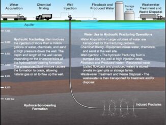
Ohio bill requires limited disclosure of chemicals used in hydraulic fracturing

9 June 2012 Geoff Zeiss

A shale-gas boom is expected in northeastern Ohio as energy companies begin to exploit the Marcellus and Utica shale deposits.  But there are concerns about the effect of hydraulic fracturing on aquifers and on seismic […]

Between the Poles – The Geoff Zeiss Archives

Top concerns in the electric power industry are reliability, aging infrastructure and the environment

7 June 2012 Geoff Zeiss

Black & Veatch has releases its sixth annual survey of the eletric power industry, 2012 Strategic Directions in the U.S. Electric Utility Industry Report, which was conducted from 22 February through 23 March 2012. The […]

Between the Poles – The Geoff Zeiss Archives

EPA finalizing 316(b) rule for cooling water intakes for power plants

7 June 2012 Geoff Zeiss

Section 316(b) of the Clean Water Act requires National Pollutant Discharge Elimination System (NPDES) permits for facilities with cooling water intakes.  Cooling water intakes affects fish, fish larvae and eggs, crustaceans, shellfish, sea turtles, marine […]

Access to Spatial Data

FDO Provider for GE Smallworld makes VMDS data available to AutoCAD clients

7 June 2012 Geoff Zeiss

The FDO Provider for GE Smallworld, developed by SBS, uses the Autodesk FDO data access technology to provide seamless, dynamic data access to GE’s Smallworld. The FDO Provider for Smallworld eliminates the need for data […]

Between the Poles – The Geoff Zeiss Archives

Autodesk announces Project Artoo for geospatial data cleanup

3 June 2012 Geoff Zeiss

Project Artoo for AutoCAD Map 3D is a free technology preview available on Autodesk Labs.  Artoo is designed to cleanup geospatial data to correct common errors that can be introduced during digitizing, importing, surveying, scanning, […]

Posts pagination

« 1 2 3

Events

Apr 27
April 27 - April 30

Welcome to the Canadian Hydrographic Conference 2026

May 3
May 3 @ 8:00 am - May 6 @ 5:00 pm

GEOINT Symposium 2026

May 11
May 11 @ 8:00 am - May 13 @ 5:00 pm

GeoIgnite 2026

May 25
May 25 - May 28

National Surveyors’ Conference 2026

May 27
May 27 @ 8:00 am - May 29 @ 5:00 pm

Canadian Cartographic Association Conference 2026

View Calendar

View All Events

Services

  • Post a Job
  • Post an Ad
  • Post an Event
  • Post a Directory Listing
  • Post a Press Release
  • Media Kit
  • My Account
  • Login

Jobs

Post a Job
  • Operations Spatial Data Assistant (Contract)
    Vaughan
  • GIS Analyst
    Saint John, New Brunswick
  • GIS Student Intern
    Elmsdale, Nova Scotia
  • Canada Impact+ Research Chair – Professor (Or Associate Professor)
    Lethbridge, Alberta
View All Jobs
  • Directories
    • Associations Directory
    • Industry Directory
    • Education Programs
    • Open Data
  • Volunteer
    • Start a GoGeomatics Group
    • Editors & Writers Group
  • About Us
    • GoGeomatics Media Kit
    • Who We Are
    • Contact Us
    • FAQ’s
    • Advertising
    • Marketing
  • Subscribe
GoGeomatics
GoGeomatics is the largest and most popular communications hub promoting the Canadian geospatial community. The business was incorporated in 2011. GoGeomatics hosts over 100 fun, free, location technology networking events each year in cities across Canada.

© 2026 GoGeomatics

  • facebook
  • Twitter
  • Linkedin
  • Youtube
  • Linkedin Group