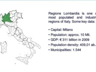
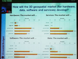
• facebook
  • Twitter
  • Linkedin
  • Youtube
  • Linkedin Group
  • Post a Job
  • Post an Ad
  • Post an Event
  • Post a Directory Listing
  • Post a Press Release
  • Media Kit
  • My Account
  • Login
GoGeomatics
  • MAGAZINE
    • BIM & GIS
    • Community
    • Conference news
    • Earth Observation
    • Education & Careers
    • GEOAI
    • Announcements
    • Reality Capture & Lidar
    • Science
    • Technology
    • Between the Poles
  • Directories
    • ASSOCIATION
    • INDUSTRY
    • EDUCATION
    • Open Data
  • EVENTS
    • GeoIgnite Events
    • Events Calendar
    • GoGeomatics Meetups
  • Services
    • Advertising
    • Marketing
    • Post a Job
    • Post an Ad
    • Post an Event
    • Post a Press Release
    • Post a Directory Listing
    • Media Kit
    • Web Design
  • Find a Job
  • Volunteer
    • Start a GoGeomatics Group
    • Editors & Writers Group
  • About Us
    • About Us
    • Contact Us
    • Frequently Asked Questions
  • Videos
Home2013July

Month: July 2013

3D data

Improving energy performance of buildings in an urban environment using 3D models

3 July 2013 Geoff Zeiss

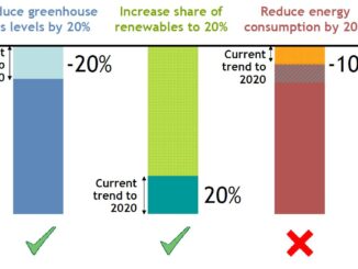
The European Union has set itself agressive goals to reduce GHG emissions by 20%, increase renewables share of energy generation to 20%, and to reduce energy cinsumption by 20% by 2020.  The EU seems to […]

3D data

Platform for urban planning for infrastructure and other municipal services

3 July 2013 Geoff Zeiss

At the INSPIRE conference in Florence, Ewa Klien, Joachim Rix and Didier Vancutsen gave an overview of an interesting EU project called Plan4business.   Plan4business is designed to address the challenges faced by urban and […]

Between the Poles – The Geoff Zeiss Archives

Mapping underground infrastructure in Northern Italy

2 July 2013 Geoff Zeiss

I have blogged numerous times about the challenge of accurately geolocating underground utilties. Most recently I blogged about the estimated ROI for investment in improving the geolocation and other information about underground utilities and the […]

3D data

Adoption of 3D GIS by European agencies

2 July 2013 Geoff Zeiss

At the INSPIRE conference in Florence, Volker Walter presented the results of a EuroSDR Survey focussed on 3D data management in European national mapping (NMCAs) and cadastral agencies. 32 organizations were surveyed. 10 NMCAs 8 […]

3D data

Incorporating utilities into highway designs

1 July 2013 Geoff Zeiss

I have blogged numerous times about the challenge of accurately geolocating underground utilties. Most recently I blogged about the estimated ROI for investment in improving the geolocation and other information about underground utilities and the […]

Posts pagination

« 1 … 4 5

Events

Sep 15
September 15 - September 17

INTERGEO 2026

Sep 16
September 16 - September 17

Join ALL IN 2026, Montreal, Canada

Oct 26
October 26 - October 28

Canada’s National Geomatics Expo 2026

Oct 27
October 27 - October 29

Rendez-vous Géomatique 2026

View Calendar

View All Events

Services

  • Post a Job
  • Post an Ad
  • Post an Event
  • Post a Directory Listing
  • Post a Press Release
  • Media Kit
  • My Account
  • Login

Jobs

Post a Job
  • GIS Technologist II
    Fernie, B.C.
  • GIS I TECHNOLOGIST
    Fernie, B.C.
  • Operations Spatial Data Assistant (Contract)
    Vaughan
  • GIS Analyst
    Saint John, New Brunswick
View All Jobs
  • Directories
    • Associations Directory
    • Industry Directory
    • Education Programs
    • Open Data
  • Volunteer
    • Start a GoGeomatics Group
    • Editors & Writers Group
  • About Us
    • GoGeomatics Media Kit
    • Who We Are
    • Contact Us
    • FAQ’s
    • Advertising
    • Marketing
  • Subscribe
GoGeomatics
GoGeomatics is the largest and most popular communications hub promoting the Canadian geospatial community. The business was incorporated in 2011. GoGeomatics hosts over 100 fun, free, location technology networking events each year in cities across Canada.

© 2026 GoGeomatics

  • facebook
  • Twitter
  • Linkedin
  • Youtube
  • Linkedin Group