• facebook
  • Twitter
  • Linkedin
  • Youtube
  • Linkedin Group
  • Post a Job
  • Post an Ad
  • Post an Event
  • Post a Directory Listing
  • Post a Press Release
  • Media Kit
  • My Account
  • Login
GoGeomatics
  • MAGAZINE
    • BIM & GIS
    • Community
    • Conference news
    • Earth Observation
    • Education & Careers
    • GEOAI
    • Announcements
    • Reality Capture & Lidar
    • Science
    • Technology
    • Between the Poles
  • Directories
    • ASSOCIATION
    • INDUSTRY
    • EDUCATION
    • Open Data
  • EVENTS
    • GeoIgnite Events
    • Events Calendar
    • GoGeomatics Meetups
  • Services
    • Advertising
    • Marketing
    • Post a Job
    • Post an Ad
    • Post an Event
    • Post a Press Release
    • Post a Directory Listing
    • Media Kit
    • Web Design
  • Find a Job
  • Volunteer
    • Start a GoGeomatics Group
    • Editors & Writers Group
  • About Us
    • About Us
    • Contact Us
    • Frequently Asked Questions
  • Videos
Home2013

Year: 2013

3D Visualization

SPAR 2013: Integrated geospatial, LiDAR and design datasets for large infrastructure construction projects

19 April 2013 Geoff Zeiss

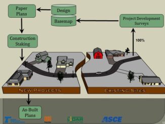
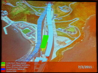
Kevin Gilson, of the Project Visualization group at Parsons Brinckerhoff (PB), gave an overview of how PB manages 3D+ datasets in support of design and construction for large infrastructure projects such as the San Francisco-Oakland […]

|||||||||||||||||||||||||||||||||||
Community

Who is Winning Canadian Geomatics Hearts and Minds on Twitter?

19 April 2013 GoGeomatics Canada | 2012

Who is Listening to you on Twitter? If you or your business aren’t on Twitter you might not even realize there is a Canadian geomatics conversation going on in the Twitter-verse.  GoGeomatics Canada is on […]

3D Visualization

SPAR 2013: BIM + GIS based facilities management at Denver International Airport

17 April 2013 Geoff Zeiss

At SPAR 2013 Dennis Rodriguez, Project Manager at Denver International Airport (DIA), and Daniel Stonecipher of Immersiv, gave a fascinating presentation on how they combined a BIM-based design and construction process with GIS  to create […]

Asset management

SPAR 2013: Integrated geospatially-enabled asset management at the Utah Department of Transportation

17 April 2013 Geoff Zeiss

The Utah Department of Transportation (UDOT) is responsible for about $30 billion in assets including pavement, bridges, signs, culverts and signals.  At SPAR 2013  Stan Burns, Asset Management Director at UDOT gave an overview of […]

3D Visualization

SPAR 2013: Digital highways require integrated engineering and geospatial data

16 April 2013 Geoff Zeiss

At SPAR 2013 I had the opportunity to hear very forward looking presentations by Ron Singh, Chief of Surveys/Geometronics Manager at the Oregon Department of Transportation.  What Ron sees in the future and what motivates […]

Asset management

SPAR 2013: Turning the construction process on its head

16 April 2013 Geoff Zeiss

At SPAR 2013 I had the opportunity to hear a very forward looking presentation by Ron Singh, Chief of Surveys/Geometronics Manager at the Oregon Department of Transportation.  It was even more impressive because Ron’s background […]

Access to Spatial Data

Value of geospatial services to the United States economy

12 April 2013 Geoff Zeiss

According to a report by the Boston Consulting Group (BCG) the geospatial services industry in the United States generates annual revenues of $75 billion annually.  That is about 0.5 % of the US GDP. The […]

Access to Spatial Data

Contribution of geospatial to the Canadian economy

11 April 2013 Geoff Zeiss

Two countries, Australia and New Zealand, have commissioned studies to estimate the contribution of geospatial data and technology to the national economy.  Canada has just announced the award of a similar project to a team that […]

Posts pagination

« 1 … 40 41 42 … 54 »

Events

Notice
There are no upcoming events.

View All Events

Services

  • Post a Job
  • Post an Ad
  • Post an Event
  • Post a Directory Listing
  • Post a Press Release
  • Media Kit
  • My Account
  • Login

Jobs

Post a Job
  • Volunteer Editorial Contributor – Be Part of Canada’s Geomatics Story
    Remote
  • Junior Geomatics Field Technician – Technical Surveys
    Montréal, QC
  • GIS Specialist
    Amherst, Nova Scotia
  • Precast Structural BIM Specialist
    Calgary, Alberta
View All Jobs
  • Directories
    • Associations Directory
    • Industry Directory
    • Education Programs
    • Open Data
  • Volunteer
    • Start a GoGeomatics Group
    • Editors & Writers Group
  • About Us
    • GoGeomatics Media Kit
    • Who We Are
    • Contact Us
    • FAQ’s
    • Advertising
    • Marketing
  • Subscribe
GoGeomatics
GoGeomatics is the largest and most popular communications hub promoting the Canadian geospatial community. The business was incorporated in 2011. GoGeomatics hosts over 100 fun, free, location technology networking events each year in cities across Canada.

© 2026 GoGeomatics

  • facebook
  • Twitter
  • Linkedin
  • Youtube
  • Linkedin Group