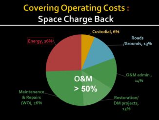
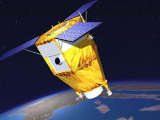
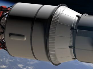
Successful launch of NASA’s new spacecraft Orion
Orion is now more than 3,000 miles above Earth after its launch on a Delta IV Heavy rocket from Florida this AM. Orion is not carrying people, but NASA wants to find out about how […]
PCI Geomatics, a world leading developer of remote sensing and photogrammetric software and systems, today announces the availability of customized Python scripts to be used in conjunction with the company’s latest release of Geomatica. Geomatica […]
Over 50% of the cost of maintaining a building is what is called operations and maintenance which is comprised of administration, maintenance and repairs, and restoration projects. In most building construction projects, even if BIM […]
Get your sleighbells jingling for the CRSS GoGeomatics Christmas Party! For the second year in a row, we’re teaming up with the Canadian Remote Sensing Society to throw a very special joint Holiday Social in […]
David Lepage, in his blog for Axiom News, expresses concern for “the map is not the territory” in a community economy. One of the cornerstones of rural economic development is asset mapping (see Kretzmann and […]
Last June Airbus Defence and Space’s SPOT 7 Earth-observation satellite was launched successfully from the Satish Dhawan Space Center in India. The first images from SPOT7 were released three days after the launch, Today SPOT […]
In June 2014, Sylvia Pinel, the Minister of Logement et de l’Égalité des territoires (Ministry of Housing), announced the intention to put in place a “French numerical strategy” with the possibility of making BIM mandatory […]
Another year is nearly over, and we’re inviting everyone in the Edmonton area to celebrate the season at our December Social with a great group of geomatics folks! We’re pleased to announce that the Alberta […]