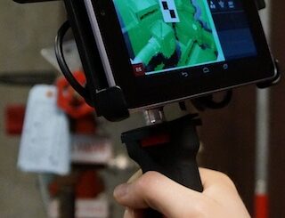
• facebook
  • Twitter
  • Linkedin
  • Youtube
  • Linkedin Group
  • Post a Job
  • Post an Ad
  • Post an Event
  • Post a Directory Listing
  • Post a Press Release
  • Media Kit
  • My Account
  • Login
GoGeomatics
  • MAGAZINE
    • BIM & GIS
    • Community
    • Conference news
    • Earth Observation
    • Education & Careers
    • GEOAI
    • Announcements
    • Reality Capture & Lidar
    • Science
    • Technology
    • Between the Poles
  • Directories
    • ASSOCIATION
    • INDUSTRY
    • EDUCATION
    • Open Data
  • EVENTS
    • GeoIgnite Events
    • Events Calendar
    • GoGeomatics Meetups
  • Services
    • Advertising
    • Marketing
    • Post a Job
    • Post an Ad
    • Post an Event
    • Post a Press Release
    • Post a Directory Listing
    • Media Kit
    • Web Design
  • Find a Job
  • Volunteer
    • Start a GoGeomatics Group
    • Editors & Writers Group
  • About Us
    • About Us
    • Contact Us
    • Frequently Asked Questions
  • Videos
Home2015January

Month: January 2015

3D data

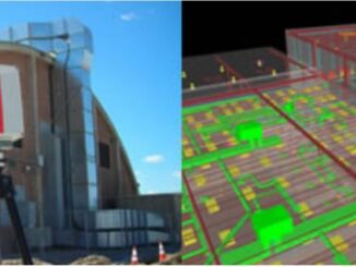
New standards for building documentation including 3D imaging and Level of Accuracy released

13 January 2015 Geoff Zeiss

In 2012 the U.S. Institute of Building Documentation (USIBD) was founded to bring together the various stakeholder groups (owner/operators, architects, engineers, contractors, surveyors, brokers, and others) to promote and facilitate building documentation as a distinct […]

Education & Careers

Geography Education: Changing Scale and Viewpoint

13 January 2015 Robert Maher | 2014

In England, as a teenager, we used to conduct ‘table top’ car rallies, using the 1 inch to 1 mile OS maps (1:63,360). The clues had to be restricted to the symbols available at that […]

No Picture
Newsmakers & Press Releases

Canadian Co. SimActive Selected by US Army Corps of Engineers for Drones

13 January 2015 GoGeomatics Newsmakers | 2015

Montreal, Canada, January 13th, 2015 – SimActive Inc., a world-leading developer of photogrammetry software, has been selected by the United States Army Corps of Engineers (USACE). They join professionals across the globe using Correlator3D™ with […]

Between the Poles – The Geoff Zeiss Archives

FAA issues grants of exemption for commercial UAV operations for construction monitoring, agriculture, and real estate

12 January 2015 Geoff Zeiss

In general the operation of unmanned aerial vehicles (UAV) for commercial purposes is illegal in the U.S.  But in the last few months the Federal Aviation Administration (FAA) has issues grants of exemption to six […]

Between the Poles – The Geoff Zeiss Archives

FOSS4G-Europe 2015 in Como, Italy July 15th to 17th open for abstract submissions

10 January 2015 Geoff Zeiss

The second FOSS4G-Europe Conference will be held at Politecnico di Milano in Como, Italy, from July 15th to 17th, 2015. A day of workshops will precede the conference on 14th July, and a code sprint […]

3D data

Hand held scanners closer to revolutionizing the construction industry

9 January 2015 Geoff Zeiss

At the SPAR International Conference in April 2014, Kirk Knorr from Burns & McDonnell and Gregory Lawes of point3D gave a presentation about their experience using a handheld scanner from DotProduct LLC , a relatively […]

No Picture
Newsmakers & Press Releases

McGill Geography Researchers Map Global Impact of Dams

7 January 2015 GoGeomatics Newsmakers | 2015

When dams are built they have an impact not only on the flow of water in the river, but also on the people who live downstream and on the surrounding ecosystems. By placing data from […]

Between the Poles – The Geoff Zeiss Archives

W3C and Open Geospatial Consortium announce new collaboration

6 January 2015 Geoff Zeiss

The social value of the Web is that it enables human communication, commerce, and opportunities to share knowledge. One of World Wide Web Consortium’s (W3C) primary goals is to make these benefits available to all […]

Posts pagination

« 1 2 3 4 »

Events

Jul 4
July 4 @ 8:00 am - July 11 @ 5:00 pm

ISPRS Congress 2026

Sep 15
September 15 - September 17

INTERGEO 2026

Sep 16
September 16 - September 17

Join ALL IN 2026, Montreal, Canada

Oct 26
October 26 - October 28

Canada’s National Geomatics Expo 2026

Oct 27
October 27 - October 29

Rendez-vous Géomatique 2026

View Calendar

View All Events

Services

  • Post a Job
  • Post an Ad
  • Post an Event
  • Post a Directory Listing
  • Post a Press Release
  • Media Kit
  • My Account
  • Login

Jobs

Post a Job
  • Geospatial Analytical Technician / Technicien, analyses géospatiales; technicienne, analyses géospatiales
    Peterborough
  • GIS Technologist II
    Fernie, B.C.
  • GIS I TECHNOLOGIST
    Fernie, B.C.
  • Senior Geohazards Specialist
    Ottawa
View All Jobs
  • Directories
    • Associations Directory
    • Industry Directory
    • Education Programs
    • Open Data
  • Volunteer
    • Start a GoGeomatics Group
    • Editors & Writers Group
  • About Us
    • GoGeomatics Media Kit
    • Who We Are
    • Contact Us
    • FAQ’s
    • Advertising
    • Marketing
  • Subscribe
GoGeomatics
GoGeomatics is the largest and most popular communications hub promoting the Canadian geospatial community. The business was incorporated in 2011. GoGeomatics hosts over 100 fun, free, location technology networking events each year in cities across Canada.

© 2026 GoGeomatics

  • facebook
  • Twitter
  • Linkedin
  • Youtube
  • Linkedin Group