• facebook
  • Twitter
  • Linkedin
  • Youtube
  • Linkedin Group
  • Post a Job
  • Post an Ad
  • Post an Event
  • Post a Directory Listing
  • Post a Press Release
  • Media Kit
  • My Account
  • Login
GoGeomatics
  • MAGAZINE
    • BIM & GIS
    • Community
    • Conference news
    • Earth Observation
    • Education & Careers
    • GEOAI
    • Announcements
    • Reality Capture & Lidar
    • Science
    • Technology
    • Between the Poles
  • Directories
    • ASSOCIATION
    • INDUSTRY
    • EDUCATION
    • Open Data
  • EVENTS
    • GeoIgnite Events
    • Events Calendar
    • GoGeomatics Meetups
  • Services
    • Advertising
    • Marketing
    • Post a Job
    • Post an Ad
    • Post an Event
    • Post a Press Release
    • Post a Directory Listing
    • Media Kit
    • Web Design
  • Find a Job
  • Volunteer
    • Start a GoGeomatics Group
    • Editors & Writers Group
  • About Us
    • About Us
    • Contact Us
    • Frequently Asked Questions
  • Videos
Home2015

Year: 2015

|
Technology

Future Prospects For 3D Geomatics In Canada

15 January 2015 Jeff_Thurston | 2015

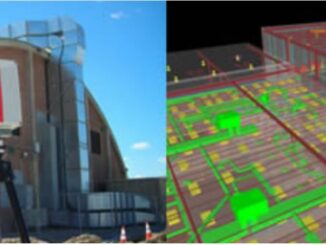
The future holds great promise for 3D when it comes to geomatics in Canadian education, industry and business. One might reasonably, and accurately, argue that 3D and visualization are a necessity in a country dominated […]

|
Education & Careers

COGS Geomatics Career Fair: Connecting Students & Industry

14 January 2015 GoGeomatics Canada | association

As geomatics students across the country are starting their final semesters of school, many are turning their thoughts to finding a job after graduation. That’s why this month, the Centre of Geographic Sciences (COGS) at […]

No Picture
Newsmakers & Press Releases

PCI Geomatics Announces Strategic Partnership with MDA for Accessing RADARSAT-2 Imagery

14 January 2015 GoGeomatics Newsmakers | 2014

MARKHAM, Ontario, Canada — PCI Geomatics, a world leading developer of remote sensing and photogrammetric software and systems, announced today a strategic partnership with McDonald, Dettwiler and Associated Ltd. (MDA). The partnership introduces a solution […]

3D data

New standards for building documentation including 3D imaging and Level of Accuracy released

13 January 2015 Geoff Zeiss

In 2012 the U.S. Institute of Building Documentation (USIBD) was founded to bring together the various stakeholder groups (owner/operators, architects, engineers, contractors, surveyors, brokers, and others) to promote and facilitate building documentation as a distinct […]

Education & Careers

Geography Education: Changing Scale and Viewpoint

13 January 2015 Robert Maher | 2014

In England, as a teenager, we used to conduct ‘table top’ car rallies, using the 1 inch to 1 mile OS maps (1:63,360). The clues had to be restricted to the symbols available at that […]

No Picture
Newsmakers & Press Releases

Canadian Co. SimActive Selected by US Army Corps of Engineers for Drones

13 January 2015 GoGeomatics Newsmakers | 2015

Montreal, Canada, January 13th, 2015 – SimActive Inc., a world-leading developer of photogrammetry software, has been selected by the United States Army Corps of Engineers (USACE). They join professionals across the globe using Correlator3D™ with […]

Between the Poles – The Geoff Zeiss Archives

FAA issues grants of exemption for commercial UAV operations for construction monitoring, agriculture, and real estate

12 January 2015 Geoff Zeiss

In general the operation of unmanned aerial vehicles (UAV) for commercial purposes is illegal in the U.S.  But in the last few months the Federal Aviation Administration (FAA) has issues grants of exemption to six […]

Between the Poles – The Geoff Zeiss Archives

FOSS4G-Europe 2015 in Como, Italy July 15th to 17th open for abstract submissions

10 January 2015 Geoff Zeiss

The second FOSS4G-Europe Conference will be held at Politecnico di Milano in Como, Italy, from July 15th to 17th, 2015. A day of workshops will precede the conference on 14th July, and a code sprint […]

Posts pagination

« 1 … 33 34 35 »

Events

Notice
There are no upcoming events.

View All Events

Services

  • Post a Job
  • Post an Ad
  • Post an Event
  • Post a Directory Listing
  • Post a Press Release
  • Media Kit
  • My Account
  • Login

Jobs

Post a Job
  • Volunteer Editorial Contributor – Be Part of Canada’s Geomatics Story
    Remote
  • Junior Geomatics Field Technician – Technical Surveys
    Montréal, QC
  • GIS Specialist
    Amherst, Nova Scotia
  • Precast Structural BIM Specialist
    Calgary, Alberta
View All Jobs
  • Directories
    • Associations Directory
    • Industry Directory
    • Education Programs
    • Open Data
  • Volunteer
    • Start a GoGeomatics Group
    • Editors & Writers Group
  • About Us
    • GoGeomatics Media Kit
    • Who We Are
    • Contact Us
    • FAQ’s
    • Advertising
    • Marketing
  • Subscribe
GoGeomatics
GoGeomatics is the largest and most popular communications hub promoting the Canadian geospatial community. The business was incorporated in 2011. GoGeomatics hosts over 100 fun, free, location technology networking events each year in cities across Canada.

© 2026 GoGeomatics

  • facebook
  • Twitter
  • Linkedin
  • Youtube
  • Linkedin Group