• facebook
  • Twitter
  • Linkedin
  • Youtube
  • Linkedin Group
  • Post a Job
  • Post an Ad
  • Post an Event
  • Post a Directory Listing
  • Post a Press Release
  • Media Kit
  • My Account
  • Login
GoGeomatics
  • MAGAZINE
    • BIM & GIS
    • Community
    • Conference news
    • Earth Observation
    • Education & Careers
    • GEOAI
    • Announcements
    • Reality Capture & Lidar
    • Science
    • Technology
    • Between the Poles
  • Directories
    • ASSOCIATION
    • INDUSTRY
    • EDUCATION
    • Open Data
  • EVENTS
    • GeoIgnite Events
    • Events Calendar
    • GoGeomatics Meetups
  • Services
    • Advertising
    • Marketing
    • Post a Job
    • Post an Ad
    • Post an Event
    • Post a Press Release
    • Post a Directory Listing
    • Media Kit
    • Web Design
  • Find a Job
  • Volunteer
    • Start a GoGeomatics Group
    • Editors & Writers Group
  • About Us
    • About Us
    • Contact Us
    • Frequently Asked Questions
  • Videos
Home2015

Year: 2015

3D data

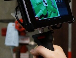
Hand held scanners closer to revolutionizing the construction industry

9 January 2015 Geoff Zeiss

At the SPAR International Conference in April 2014, Kirk Knorr from Burns & McDonnell and Gregory Lawes of point3D gave a presentation about their experience using a handheld scanner from DotProduct LLC , a relatively […]

No Picture
Newsmakers & Press Releases

McGill Geography Researchers Map Global Impact of Dams

7 January 2015 GoGeomatics Newsmakers | 2015

When dams are built they have an impact not only on the flow of water in the river, but also on the people who live downstream and on the surrounding ecosystems. By placing data from […]

Between the Poles – The Geoff Zeiss Archives

W3C and Open Geospatial Consortium announce new collaboration

6 January 2015 Geoff Zeiss

The social value of the Web is that it enables human communication, commerce, and opportunities to share knowledge. One of World Wide Web Consortium’s (W3C) primary goals is to make these benefits available to all […]

||
Community

Will There Be A Canadian Geospatial Student Union?

6 January 2015 Jon Murphy | 2014

Would you support a national Canadian geospatial student union that provided job opportunities, co-ops, and internship positions by becoming a paid member? That’s one of the questions we asked on our GoGeomatics Back to School […]

Posts pagination

« 1 … 34 35

Events

Notice
There are no upcoming events.

View All Events

Services

  • Post a Job
  • Post an Ad
  • Post an Event
  • Post a Directory Listing
  • Post a Press Release
  • Media Kit
  • My Account
  • Login

Jobs

Post a Job
  • Volunteer Editorial Contributor – Be Part of Canada’s Geomatics Story
    Remote
  • Junior Geomatics Field Technician – Technical Surveys
    Montréal, QC
  • GIS Specialist
    Amherst, Nova Scotia
  • Precast Structural BIM Specialist
    Calgary, Alberta
View All Jobs
  • Directories
    • Associations Directory
    • Industry Directory
    • Education Programs
    • Open Data
  • Volunteer
    • Start a GoGeomatics Group
    • Editors & Writers Group
  • About Us
    • GoGeomatics Media Kit
    • Who We Are
    • Contact Us
    • FAQ’s
    • Advertising
    • Marketing
  • Subscribe
GoGeomatics
GoGeomatics is the largest and most popular communications hub promoting the Canadian geospatial community. The business was incorporated in 2011. GoGeomatics hosts over 100 fun, free, location technology networking events each year in cities across Canada.

© 2026 GoGeomatics

  • facebook
  • Twitter
  • Linkedin
  • Youtube
  • Linkedin Group