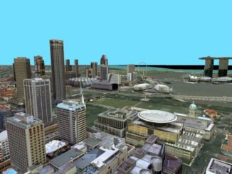
• facebook
  • Twitter
  • Linkedin
  • Youtube
  • Linkedin Group
  • Post a Job
  • Post an Ad
  • Post an Event
  • Post a Directory Listing
  • Post a Press Release
  • Media Kit
  • My Account
  • Login
GoGeomatics
  • MAGAZINE
    • BIM & GIS
    • Community
    • Conference news
    • Earth Observation
    • Education & Careers
    • GEOAI
    • Announcements
    • Reality Capture & Lidar
    • Science
    • Technology
  • Directories
    • ASSOCIATION
    • INDUSTRY
    • EDUCATION
    • Open Data
  • EVENTS
    • GeoIgnite Events
    • Events Calendar
    • GoGeomatics Meetups
  • Services
    • Advertising
    • Marketing
    • Post a Job
    • Post an Ad
    • Post an Event
    • Post a Press Release
    • Post a Directory Listing
    • Media Kit
    • Web Design
  • Find a Job
  • Volunteer
    • Start a GoGeomatics Group
    • Editors & Writers Group
  • About Us
    • About Us
    • Contact Us
    • Frequently Asked Questions
  • Videos
Home2015

Year: 2015

Advice|Geography Canada
Education & Careers

Perspective is everything: The St. John’s Declaration & Geographic Education

1 October 2015 Peggy March | 2013

I am a retired geographic educator. I am a geographer. I understand GIS. Or should I say I LOVE Geomatics? I have spent my career promoting geo-literacy/geospatial literacy. I am geospatially-oriented. This is my point […]

No Picture
Newsmakers & Press Releases

Trimble Introduces Next Generation Indoor Mobile Mapping System

1 October 2015 GoGeomatics Newsmakers | 2016

TIMMS 2–Smaller, Lighter and Easier to Maneuver System Maximizes Performance in Indoor Spaces While Delivering Accurate, High-Quality Data Trimble (NASDAQ: TRMB) introduced its next generation Trimble® Indoor Mobile Mapping Solution (TIMMS) that produces fast and […]

No Picture
Newsmakers & Press Releases

PlanetSAT 15 L8: the new up-to-date, homogeneous and natural colour imagery base map with 15-meter resolution.

30 September 2015 GoGeomatics Newsmakers | 2013

The French company PlanetObserver, specialized in imagery base map production for more than 25 years, announced the coverage of more than 50 Mill. sq km with PlanetSAT 15 L8 base map. Processed from Landsat 8 […]

No Picture
Technology

Web Mercator: the de facto standard, the controversy, and the opportunity

23 September 2015 Emmanuel Stefanakis | 2014

Four hundred and fifty years ago, the Flemish geographer and cartographer Gerardus Mercator presented the most popular map projection ever. It became fairly the standard projection for nautical maps because of its ability to represent […]

No Picture
Community

Beyond the Outer Shores

22 September 2015 Robert Maher | 2012

For over fifty years, the islands off the coast of British Columbia and Alaska have been called ‘the outer shores’. This goes back to the pioneering exploration by Ed Ricketts, an ecologist, who gained renown […]

No Picture
Newsmakers & Press Releases

Montreal: AeroVironment Chooses SimActive’s Correlator3D™

22 September 2015 GoGeomatics Newsmakers | 2015

Montreal, Canada, September 22nd, 2015 – SimActive Inc., a world-leading developer of photogrammetry software, is pleased to announce that AeroVironment has selected Correlator3D™ for post-processing UAV imagery. “We required an advanced photogrammetry solution to process […]

No Picture
Newsmakers & Press Releases

GPS Galileo taking flight: ten satellites now in orbit

16 September 2015 GoGeomatics Newsmakers | api

Europe’s own satellite navigation system has come a step nearer to completion, with Galileo 9 and 10 which lifted off together at 02:08 GMT on 11 September (04:08 CEST; 23:08 local time, 10 September) from Europe’s […]

No Picture
Newsmakers & Press Releases

OGC Seeks Sponsors for FutureCities Pilot

16 September 2015 GoGeomatics Newsmakers | 2015

The Open Geospatial Consortium (OGC®) in collaboration with buildingSMART International (bSI) invites sponsorship in a pilot project to help cities around the world benefit from modern standards for geospatial technologies. The Pilot, based in Europe, […]

Posts pagination

« 1 … 5 6 7 … 26 »

Events

Sep 15
September 15, 2026 - September 17, 2026

INTERGEO 2026

Sep 16
September 16, 2026 - September 17, 2026

Join ALL IN 2026, Montreal, Canada

Oct 27
October 27, 2026 - October 29, 2026

Rendez-vous Géomatique 2026

View Calendar

View All Events

Services

  • Post a Job
  • Post an Ad
  • Post an Event
  • Post a Directory Listing
  • Post a Press Release
  • Media Kit
  • My Account
  • Login

Jobs

Post a Job
  • Canada Maps and Poster Gallery Volunteer Leads — GeoIgnite 2026
    remote
  • GIS & Data Analytics Lead
    Beaumont, AB
  • Lead Surveyor, Projects/Arpenteur-géomètre principal, projets; arpenteuse-géomètre principale, projets
    North Bay, Thunder Bay
  • Senior GIS Developer
    Calgary, AB
View All Jobs
  • Directories
    • Associations Directory
    • Industry Directory
    • Education Programs
    • Open Data
  • Volunteer
    • Start a GoGeomatics Group
    • Editors & Writers Group
  • About Us
    • GoGeomatics Media Kit
    • Who We Are
    • Contact Us
    • FAQ’s
    • Advertising
    • Marketing
  • Subscribe
GoGeomatics
GoGeomatics is the largest and most popular communications hub promoting the Canadian geospatial community. The business was incorporated in 2011. GoGeomatics hosts over 100 fun, free, location technology networking events each year in cities across Canada.

© 2025 GoGeomatics

  • facebook
  • Twitter
  • Linkedin
  • Youtube
  • Linkedin Group