• facebook
  • Twitter
  • Linkedin
  • Youtube
  • Linkedin Group
  • Post a Job
  • Post an Ad
  • Post an Event
  • Post a Directory Listing
  • Post a Press Release
  • Media Kit
  • My Account
  • Login
GoGeomatics
  • MAGAZINE
    • BIM & GIS
    • Community
    • Conference news
    • Earth Observation
    • Education & Careers
    • GEOAI
    • Announcements
    • Reality Capture & Lidar
    • Science
    • Technology
    • Between the Poles
  • Directories
    • ASSOCIATION
    • INDUSTRY
    • EDUCATION
    • Open Data
  • EVENTS
    • GeoIgnite Events
    • Events Calendar
    • GoGeomatics Meetups
  • Services
    • Advertising
    • Marketing
    • Post a Job
    • Post an Ad
    • Post an Event
    • Post a Press Release
    • Post a Directory Listing
    • Media Kit
    • Web Design
  • Find a Job
  • Volunteer
    • Start a GoGeomatics Group
    • Editors & Writers Group
  • About Us
    • About Us
    • Contact Us
    • Frequently Asked Questions
  • Videos
Home2018February

Month: February 2018

No Picture
3D data

Automating sustainable building design using BIM and energy performance modeling

19 February 2018 Geoff Zeiss

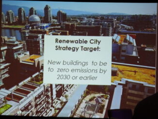
At the CanBIM Regional Session in Vancouver, Mark Cichy, Associate, Director of Computational Design and Research, at DIALOG, gave a fascinating talk about automating the process of designing sustainable buildings.  Specifically the talk focussed on […]

|
Community

Book Review of “Great Lengths, A Celebration of The Surveyors of Ontario”

12 February 2018 Mike Strutt

A surveyor and a platypus walk into a bar…. All right, I made that up, but did you hear the story of the surveyor that crashed through the ice in sub zero temperatures, had to […]

Between the Poles – The Geoff Zeiss Archives

Vancouver’s strategy for zero emissions buildings by 2030

9 February 2018 Geoff Zeiss

New buildings in Vancouver will be zero-emissions or zero-emissions ready by 2030 or earlier. Vancouver will achieve this by a combination of energy usage reporting, incentives to the private sector, regulation including rezoning and building […]

Access to Spatial Data

Open source-based mobile viewer creates value for electric power utilities with multiple GISs

8 February 2018 Geoff Zeiss

One of the challenges faced by large utilities with multiple GIS, outage management, customer information and other systems, which are often the result of mergers, is how to make spatial and associated data, in different, […]

|National Geomatics Competition 2018|GoGeomatics & National Geomatics Competition Social Extravaganza
Education & Careers

February Live in Canada: National Geomatics Competition on Social Media

7 February 2018 GoGeomatics Canada | Canada

GoGeomatics Canada is excited about the first national Canadian Geomatics Competition taking place this February 16 to the 19, 2018. This event offers geomatics students the chance to prove their talent to some of the […]

|
Newsmakers & Press Releases

URISA BC Feb 22: Get Smart! Smarter Communities with GIS

6 February 2018 GoGeomatics Newsmakers | 2018

February 22, 2018 at the Hilton Vancouver Metrotown Early-bird Registration ends February 8th. Register now to take advantage of the discounted rates. The latest advances in Geographic Information Systems and related technology devices have enabled […]

3D data

High resolution satellite imagery helps innovative electric utility optimize vegetation management

5 February 2018 Geoff Zeiss

Vegetation is a significant source of outages for many utilities. In some regions from one quarter to one half of all outages can be ascribed to vegetation.  Vegetation encroachment initiated the massive North American northeastern […]

Figure 3: Unsupervised classification result of Simcoe County.|Figure 1: The 2005 greenbelt plan and its inner municipalities. Image courtesy of Friends of the Greenbelt Foundation.|Figure 2: Simcoe County (highlighted in mahogany) in relation to the Greater Golden Horseshoe (GGH). Image courtesy of Open Street Map.|Figure 4: Urban sprawl in the southern half of Simcoe County
Technology

Using GIS to Examine Leapfrog Development Beyond the Ontario Greenbelt

5 February 2018 Jonathan Scida | Canada

Since its establishment by the Ontario government in 2005, the Places to Grow Act is a policy envisaged at curbing the effects of urban sprawl and encouraging population growth where it is needed. According to […]

Posts pagination

« 1 2

Events

Feb 24
All day

Digital Leadership Day Federal

Feb 24
February 24 - February 26

Government Innovation Week – Federal

Feb 24
5:30 pm - 7:30 pm

GoGeomatics Kelowna February Social

Feb 24
5:30 pm - 7:30 pm

Kelowna Mural Map – User Feedback & Networking Social

Feb 24
6:30 pm - 8:30 pm

February Ottawa GoGeomatics Meetup

View Calendar

View All Events

Services

  • Post a Job
  • Post an Ad
  • Post an Event
  • Post a Directory Listing
  • Post a Press Release
  • Media Kit
  • My Account
  • Login

Jobs

Post a Job
  • Volunteer Editorial Contributor – Be Part of Canada’s Geomatics Story
    Remote
  • Junior Geomatics Field Technician – Technical Surveys
    Montréal, QC
  • GIS Specialist
    Amherst, Nova Scotia
  • Precast Structural BIM Specialist
    Calgary, Alberta
View All Jobs
  • Directories
    • Associations Directory
    • Industry Directory
    • Education Programs
    • Open Data
  • Volunteer
    • Start a GoGeomatics Group
    • Editors & Writers Group
  • About Us
    • GoGeomatics Media Kit
    • Who We Are
    • Contact Us
    • FAQ’s
    • Advertising
    • Marketing
  • Subscribe
GoGeomatics
GoGeomatics is the largest and most popular communications hub promoting the Canadian geospatial community. The business was incorporated in 2011. GoGeomatics hosts over 100 fun, free, location technology networking events each year in cities across Canada.

© 2026 GoGeomatics

  • facebook
  • Twitter
  • Linkedin
  • Youtube
  • Linkedin Group