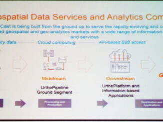
• facebook
  • Twitter
  • Linkedin
  • Youtube
  • Linkedin Group
  • Post a Job
  • Post an Ad
  • Post an Event
  • Post a Directory Listing
  • Post a Press Release
  • Media Kit
  • My Account
  • Login
GoGeomatics
  • MAGAZINE
    • BIM & GIS
    • Community
    • Conference news
    • Earth Observation
    • Education & Careers
    • GEOAI
    • Announcements
    • Reality Capture & Lidar
    • Science
    • Technology
  • Directories
    • ASSOCIATION
    • INDUSTRY
    • EDUCATION
    • Open Data
  • EVENTS
    • GeoIgnite Events
    • Events Calendar
    • GoGeomatics Meetups
  • Services
    • Advertising
    • Marketing
    • Post a Job
    • Post an Ad
    • Post an Event
    • Post a Press Release
    • Post a Directory Listing
    • Media Kit
    • Web Design
  • Find a Job
  • Volunteer
    • Start a GoGeomatics Group
    • Editors & Writers Group
  • About Us
    • About Us
    • Contact Us
    • Frequently Asked Questions
  • Videos
Home2019

Year: 2019

||||||||
Technology

A Simple Automated Web Mapping System: Combining Data Collection and Mapping

4 April 2019 Joey Syer | ArcGIS

My previous article discussed the collection of non-spatial data. I’ll now introduce the concepts of collecting spatial data alongside it and making it automatically accessible through web maps. The Plan Hundreds, if not thousands, of […]

|
Technology

Chief Pilot for Cooke & Associates Inc Summarizes the Coming UAV regulation Changes in Canada

30 March 2019 GoGeomatics Canada | Certifications

The new Canadian Air Regulations are complex pieces of literature for those unable to parse legalese. Luckily David Cooke, Chief Pilot of Cooke & Associates Inc., has taken the initiative to create a plain language […]

Newsmakers & Press Releases

Emlid Reach RS2: multi-band RTK GNSS receiver for $1899

29 March 2019 Irina Dyacheva

Emlid, the creators of Reach, centimeter-accurate RTK GNSS receiver, launched pre-orders for their multi-band GNSS receiver Reach RS2. The new receiver features built-in LoRa radio, 3.5G modem and a survey app for iOS and Android. […]

|||||
Technology

Your Canadian Geospatial Briefing for April 1st: Geospatial World Forum; Maxar NaturalVue; GeoIgnite in GIS User; Canadians win Turing Award

29 March 2019 GoGeomatics Canada | AI

GoGeomatics heads to Amsterdam GoGeomatics founder Jonathan Murphy will be attending the Geospatial World forum April 2nd-4th to take part in an annual gathering of representatives from the world of location technology. The Forum attracts over […]

|||||||
Education & Careers

The Top 5 IT Certifications geospatial professionals need to consider

27 March 2019 Jon Murphy | Certification

It is essential that geospatial professionals be aware of which available certifications are considered attractive to organizations, as they indicate trends related to current technology and knowledge. Cloud skills are critical for most organizations, especially […]

||
Technology

Your Global Geospatial Briefing for March 25th: Gaofen satellites; Will Cadell; Uk Space Agency; CARICOM; Future Cities Canada

25 March 2019 GoGeomatics Canada | Caribbean

Chinese Earth Satellites launched The Gaofen-5 and Gaofen-6 Chinese Earth observation satellites have officially been put into service. During in-orbit tests the satellites provided data on environmental monitoring, natural resources, and natural disasters. China is […]

|
Community

Key Canadian Thought Leader Discusses Positive Geospatial Disruption in Government

22 March 2019 GoGeomatics Canada | business

Longtime followers of GoGeomatics recognize Will Cadell’s name. We’ve interviewed him here at GoGeomatics, he’s the lead consultant at Sparkgeo, and he has been helping start-ups, large enterprises, and non-profits across North America make the […]

||||
Technology

Hatfield releases R-BAM algorithm to all Canadian wildfire agencies

21 March 2019 Andy Dean | algorithm

The Rapid Burned Area Mapping (R-BAM) technology was developed over the last three years by Hatfield Consultants and aims to complement conventional wildfire observation and assessment techniques by providing frequent updates on wildfire burn areas […]

Posts pagination

« 1 … 15 16 17 … 22 »

Events

Notice
There are no upcoming events.

View All Events

Services

  • Post a Job
  • Post an Ad
  • Post an Event
  • Post a Directory Listing
  • Post a Press Release
  • Media Kit
  • My Account
  • Login

Jobs

Post a Job
  • Canada Maps and Poster Gallery Volunteer Leads — GeoIgnite 2026
    remote
  • SENIOR PLANNER SPATIAL ANALYSIS SIPA
    Toronto, ON
  • Data & GIS Specialist, Exploration
    Toronto, ON
  • Geospatial Technical Support and Training Specialist
    Ontario, Canada
View All Jobs
  • Directories
    • Associations Directory
    • Industry Directory
    • Education Programs
    • Open Data
  • Volunteer
    • Start a GoGeomatics Group
    • Editors & Writers Group
  • About Us
    • GoGeomatics Media Kit
    • Who We Are
    • Contact Us
    • FAQ’s
    • Advertising
    • Marketing
  • Subscribe
GoGeomatics
GoGeomatics is the largest and most popular communications hub promoting the Canadian geospatial community. The business was incorporated in 2011. GoGeomatics hosts over 100 fun, free, location technology networking events each year in cities across Canada.

© 2025 GoGeomatics

  • facebook
  • Twitter
  • Linkedin
  • Youtube
  • Linkedin Group