• facebook
  • Twitter
  • Linkedin
  • Youtube
  • Linkedin Group
  • Post a Job
  • Post an Ad
  • Post an Event
  • Post a Directory Listing
  • Post a Press Release
  • Media Kit
  • My Account
  • Login
GoGeomatics
  • MAGAZINE
    • BIM & GIS
    • Community
    • Conference news
    • Earth Observation
    • Education & Careers
    • GEOAI
    • Announcements
    • Reality Capture & Lidar
    • Science
    • Technology
    • Between the Poles
  • Directories
    • ASSOCIATION
    • INDUSTRY
    • EDUCATION
    • Open Data
  • EVENTS
    • GeoIgnite Events
    • Events Calendar
    • GoGeomatics Meetups
  • Services
    • Advertising
    • Marketing
    • Post a Job
    • Post an Ad
    • Post an Event
    • Post a Press Release
    • Post a Directory Listing
    • Media Kit
    • Web Design
  • Find a Job
  • Volunteer
    • Start a GoGeomatics Group
    • Editors & Writers Group
  • About Us
    • About Us
    • Contact Us
    • Frequently Asked Questions
  • Videos
Home2020

Year: 2020

No Picture
Between the Poles – The Geoff Zeiss Archives

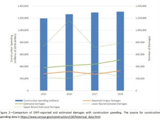
Cost of underground utility damage represents a major drag on national economies

14 April 2020 Geoff Zeiss

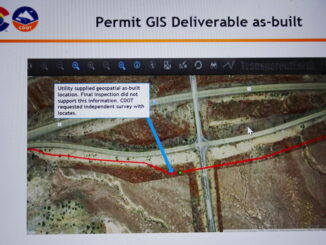
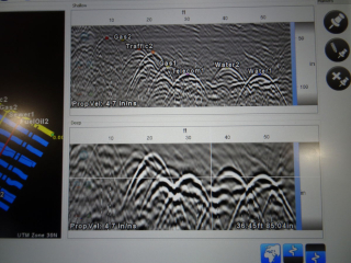
Underground utility damage is expensive. Several jurisdictions have attempted to estimate the cost of underground utility damage for individual incidents and for entire national economies. Costs can be broken down into direct costs and indirect […]

3D data

Acoustic location works where EM and GPR techniques don’t for locating underground infrastructure

9 April 2020 Geoff Zeiss

There have been significant advances in technologies for detecting underground infrastructure including inertial locating, novel radar technologies applied to ground penetrating radar (GPR), and software for post processing GPR signals to produce tomographic images. Each […]

Between the Poles – The Geoff Zeiss Archives

Hybrid GIS and survey system tackles low quality underground utility location information

7 April 2020 Geoff Zeiss

At the fourth Digital Underground Connect (DUConnect) session, Rob Martindale, Utility Program Manager at the Colorado Department of Transportation (CDOT) provided an overview of a remarkable initiative by the State of Colorado to address the […]

Between the Poles – The Geoff Zeiss Archives

The role of surveyors in locating and mapping underground utilities

6 April 2020 Geoff Zeiss

Accurately mapping underground utility and telecom network assets represents a growing opportunity for professional surveyors. In order to ensure continuing improvement in the accuracy of location information about underground utilities, some international jurisdictions are requiring […]

Community

GoGeomatics Virtual Events: Week of April 6th – 10th, 2020

6 April 2020 Jon Murphy | Canada

GoGeomatics is expanding our activities online. For all of us stuck at home and looking to connect we are going to offer more opportunities for the Canadian geospatial community to engage. To kick us off […]

3D data

Practical benefits of accurate mapping of underground utilities for construction projects

31 March 2020 Geoff Zeiss

Government agencies and construction firms are recognizing the significant benefits of an accurate map of underground infrastructure for construction projects. Here we describe how accurate models of underground infrastructure bring practical benefits to construction projects. […]

Between the Poles – The Geoff Zeiss Archives

Comprehensive approach essential for reducing underground utility damage during construction

26 March 2020 Geoff Zeiss

Comparing the United States and Japan reveals a startling difference in the number of incidents of underground utility damage during construction. In the U.S. the number of incidents is between 400,000 and 800,000 per year […]

Community

GeoIgnite 2020 COVID-19 Update

25 March 2020 GoGeomatics Canada | conference

The disruption presented by the COVID-19 pandemic is unprecedented in our lifetimes. GeoIgnite will not take place in June of this year but be postponed. With news of the pandemic evolving daily, GoGeomatics Canada has […]

Posts pagination

« 1 … 19 20 21 … 26 »

Events

Notice
There are no upcoming events.

View All Events

Services

  • Post a Job
  • Post an Ad
  • Post an Event
  • Post a Directory Listing
  • Post a Press Release
  • Media Kit
  • My Account
  • Login

Jobs

Post a Job
  • GIS Technologist II
    Fernie, B.C.
  • GIS I TECHNOLOGIST
    Fernie, B.C.
  • Operations Spatial Data Assistant (Contract)
    Vaughan
  • GIS Analyst
    Saint John, New Brunswick
View All Jobs
  • Directories
    • Associations Directory
    • Industry Directory
    • Education Programs
    • Open Data
  • Volunteer
    • Start a GoGeomatics Group
    • Editors & Writers Group
  • About Us
    • GoGeomatics Media Kit
    • Who We Are
    • Contact Us
    • FAQ’s
    • Advertising
    • Marketing
  • Subscribe
GoGeomatics
GoGeomatics is the largest and most popular communications hub promoting the Canadian geospatial community. The business was incorporated in 2011. GoGeomatics hosts over 100 fun, free, location technology networking events each year in cities across Canada.

© 2026 GoGeomatics

  • facebook
  • Twitter
  • Linkedin
  • Youtube
  • Linkedin Group