• facebook
  • Twitter
  • Linkedin
  • Youtube
  • Linkedin Group
  • Post a Job
  • Post an Ad
  • Post an Event
  • Post a Directory Listing
  • Post a Press Release
  • Media Kit
  • My Account
  • Login
GoGeomatics
  • MAGAZINE
    • BIM & GIS
    • Community
    • Conference news
    • Earth Observation
    • Education & Careers
    • GEOAI
    • Announcements
    • Reality Capture & Lidar
    • Science
    • Technology
    • Between the Poles
  • Directories
    • ASSOCIATION
    • INDUSTRY
    • EDUCATION
    • Open Data
  • EVENTS
    • GeoIgnite Events
    • Events Calendar
    • GoGeomatics Meetups
  • Services
    • Advertising
    • Marketing
    • Post a Job
    • Post an Ad
    • Post an Event
    • Post a Press Release
    • Post a Directory Listing
    • Media Kit
    • Web Design
  • Find a Job
  • Volunteer
    • Start a GoGeomatics Group
    • Editors & Writers Group
  • About Us
    • About Us
    • Contact Us
    • Frequently Asked Questions
  • Videos
Home2022September

Month: September 2022

|
Technology

Future of Geospatial Artificial Intelligence

7 September 2022 Zalak Bhavsar | ArtificialIntelligence

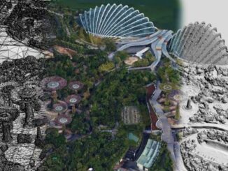
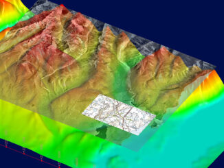
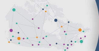
Geospatial artificial intelligence or GeoAI is a type of artificial intelligence or machine learning that is used to model future results. It operates on GIS technology and utilises tools for statistical modelling, computer vision, and […]

||
Technology

International Geospatial Briefing Sept 5

5 September 2022 GoGeomatics Canada | 3D CAD

1. Geospatial 3D without VR 2. Geospatial Project Management 3. Singapore’s Digital Twin 4. Cool Spots in Hot Cities Mapped 5. Upgrading Hawaii’s Active Control 6. Mapping Pakistan’s Floods Seeing the Whole Geospatial Picture in […]

|||||
Technology

Digital twins and sustainable mining: A look at 3D modelling with Leapfrog Geo

2 September 2022 Jake MacLean | 3D modeling

From underground infrastructure mapping to smart cities preparing for natural disasters, digital twins are becoming an important part of geospatial projects. While the first GIS was created to quantify Canada’s vast reserves of natural resources, […]

Community

Call for Nominations: Canadian Open Data Awards 2022, Deadline: October 1st

2 September 2022 Jon Murphy | Awards

What: The Canadian Open Data Society recognizing and celebrating excellence in open data in Canada through the Canadian Open Data Awards When: Nominations open: September 1, 2022 Nominations close: October 1, 2022, UTC-4. Send nominations […]

|
Newsmakers & Press Releases

Canada’s Teledyne Geospatial Sells Optech Galaxy PRIME Lidar System to Fototerra

1 September 2022 GoGeomatics Newsmakers | agriculture

Vaughan, Ontario, CANADA – September 1, 2022 – Teledyne Geospatial is pleased to announce the sale of its Optech Galaxy PRIME to Fototerra, an aerospace and service company that specializes in airborne remote sensing services, […]

||
Technology

Hyperspectral imagery applications in mineral exploration

1 September 2022 Jake MacLean | exploration geology

Remotely sensed data has been providing insights into how the world works for decades now. From the first implementation of aerial photographs to the advances of WWII that lead to the development of sonar and […]

Posts pagination

« 1 … 3 4

Events

Jun 1
June 1 - June 4

CAG/CARTO Annual Meeting 2026

Jul 4
July 4 @ 8:00 am - July 11 @ 5:00 pm

ISPRS Congress 2026

Sep 15
September 15 - September 17

INTERGEO 2026

Sep 16
September 16 - September 17

Join ALL IN 2026, Montreal, Canada

Oct 26
October 26 - October 28

Canada’s National Geomatics Expo 2026

View Calendar

View All Events

Services

  • Post a Job
  • Post an Ad
  • Post an Event
  • Post a Directory Listing
  • Post a Press Release
  • Media Kit
  • My Account
  • Login

Jobs

Post a Job
  • Operations Spatial Data Assistant (Contract)
    Vaughan
  • GIS Analyst
    Saint John, New Brunswick
  • GIS Student Intern
    Elmsdale, Nova Scotia
  • Canada Impact+ Research Chair – Professor (Or Associate Professor)
    Lethbridge, Alberta
View All Jobs
  • Directories
    • Associations Directory
    • Industry Directory
    • Education Programs
    • Open Data
  • Volunteer
    • Start a GoGeomatics Group
    • Editors & Writers Group
  • About Us
    • GoGeomatics Media Kit
    • Who We Are
    • Contact Us
    • FAQ’s
    • Advertising
    • Marketing
  • Subscribe
GoGeomatics
GoGeomatics is the largest and most popular communications hub promoting the Canadian geospatial community. The business was incorporated in 2011. GoGeomatics hosts over 100 fun, free, location technology networking events each year in cities across Canada.

© 2026 GoGeomatics

  • facebook
  • Twitter
  • Linkedin
  • Youtube
  • Linkedin Group