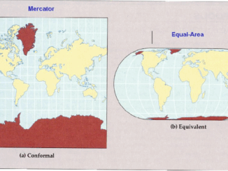
From Mercator to Equal Earth: A Turning Point in Map Representation?
When we look at a map, it feels like we are seeing the world as it is. Oceans, continents, and countries laid out neatly on a page or a screen. But every map is a […]
This interview is part of our series on Canada’s infrastructure moment and its impact on the geospatial/geomatics sector. Canada is entering a period of unprecedented infrastructure investment, and with it comes a defining question: Is […]
This November, Charlie Trimble — the pioneering technologist who helped turn GPS into a global utility — will speak at the GoGeomatics Expo 2025 in Calgary. It’s a rare public appearance from someone long retired […]
NOAA Upheaval Raises Concerns as U.S. Nears Peak Hurricane Season India’s Private Space Industry to Launch 12-Satellite EO Network Under PPP What’s Next for Landsat and Civilian Earth Observation Mapping the Future: Google AlphaEarth Foundations […]
Prime Minister Mark Carney announced last week that the federal government will establish a Federal Major Projects Office to oversee and expedite projects designated as being in the national interest under the new Building Canada […]
The federal government is exploring the creation of a digital twin to manage some of Canada’s most complex and high-profile infrastructure — spanning heritage buildings in the Parliamentary Precinct to specialized Laboratories Canada facilities. Public […]
Canada is embarking on one of the largest infrastructure investments in its history — dedicating 1.5% of GDP to critical infrastructure as part of a broader 5% commitment in defence. This scale of spending represents […]
The Canada Maps & Poster Gallery returns to the GoGeomatics Expo in 2025 as one of the most anticipated features of the program. Taking place on Tuesday, November 4 and 5th, 2025, from 9:00 AM […]