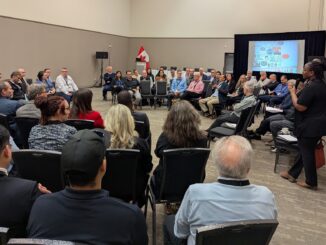
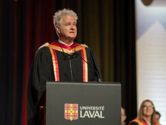
• facebook
  • Twitter
  • Linkedin
  • Youtube
  • Linkedin Group
  • Post a Job
  • Post an Ad
  • Post an Event
  • Post a Directory Listing
  • Post a Press Release
  • Media Kit
  • My Account
  • Login
GoGeomatics
  • MAGAZINE
    • BIM & GIS
    • Community
    • Conference news
    • Earth Observation
    • Education & Careers
    • GEOAI
    • Announcements
    • Reality Capture & Lidar
    • Science
    • Technology
  • Directories
    • ASSOCIATION
    • INDUSTRY
    • EDUCATION
    • Open Data
  • EVENTS
    • GeoIgnite Events
    • Events Calendar
    • GoGeomatics Meetups
  • Services
    • Advertising
    • Marketing
    • Post a Job
    • Post an Ad
    • Post an Event
    • Post a Press Release
    • Post a Directory Listing
    • Media Kit
    • Web Design
  • Find a Job
  • Volunteer
    • Start a GoGeomatics Group
    • Editors & Writers Group
  • About Us
    • About Us
    • Contact Us
    • Frequently Asked Questions
  • Videos
Home2025

Year: 2025

BIM & GIS

From Smart Maps to Safer Communities: Canada’s New Era of Flood Resilience

27 July 2025 Farzaneh Farshad | AI in Flood Modeling

In June 2025, the Government of Canada announced a $6.8 million investment in 20 new flood-mapping and adaptation projects under the Flood Hazard Identification and Mapping Program (FHIMP). These initiatives promise to revolutionize how we […]

BIM & GIS

How to Bridge Reality and Digital Space – A Conversation with John Hale

27 July 2025 David Legris | #buildingSMARTCanada

Canada’s progress on Building Information Modelling (BIM) standardization and alignment with other spatial technologies has been steadily improving through the work of organization like buildingSMART Canada. Helping to lead this change is John Hale, the […]

Community

« …Vaste, profond et en perpétuel mouvement… » : Denis Hains reçoit un Doctorat Honoris Causa (D.H.C.)

27 July 2025 Benedicta Antwi Boasiako | Cartographie marine

Lien vers la version anglaise ici Après avoir reçu le prix Sam-Masry 2024, Denis Hains est une fois de plus honoré, cette fois par la plus haute distinction académique de l’Université Laval, célébrant une vie […]

BIM & GIS

Teledyne CARIS and UK Hydrographic Office Partner to Transform Hydrographic Processing and Nautical Charting

24 July 2025 GoGeomatics Canada | ADMIRALTY Products

Teledyne CARIS and the UK Hydrographic Office (UKHO) have launched a multi-year strategic partnership aimed at transforming the way hydrographic data is processed, and nautical charts are produced, the company said in a statement. This […]

Earth Observation

GHGSat Becomes First Canadian Company to Join the International Charter: Space and Major Disasters as a Data Contributor

24 July 2025 GoGeomatics Canada | Canadian Innovation Leadership

Montreal-headquartered GHGSat, the global leader in emissions monitoring technology, has become the first Canadian company to join the International Charter: Space and Major Disasters as a data contributor, providing its data as part of a […]

Carina
BIM & GIS

Canada’s Surveying Workforce Crisis: SAIT’s Carina Butterworth on Fixing the Pipeline

22 July 2025 Anusuya Datta | BCIT

Canada is entering a once-in-a-generation infrastructure boom — ports, roads, pipelines, renewable energy projects, and national security initiatives are all ramping up under the federal government’s 1.5% GDP commitment to critical infrastructure. But even before […]

Earth Observation

Shifting Zones: The Evolution of Canada’s Plant Hardiness System

22 July 2025 Alefiya Dungrawala | Canadian Forest Services

Over hundreds of thousands of years, the Earth — along with its climate, topography, and terrain — has undergone profound transformations driven by both natural forces and, more recently, human activities. Long-standing climatic conditions in […]

Canadian Digest Jul 21
Community

Canadian Geospatial Digest July 21, 2025

21 July 2025 GoGeomatics Canada | Acoustic monitoring

Navy Testing Explosive Drone Boat in First Proof of ‘New Operational Concept’ New Mapping Tool Supports Aquaculture Growth Esri Adds Indigenous Datasets in the New Living Atlas Nearly a Third of Forests in Northeast B.C. Could […]

Posts pagination

« 1 … 23 24 25 … 54 »

Events

Notice
There are no upcoming events.

View All Events

Services

  • Post a Job
  • Post an Ad
  • Post an Event
  • Post a Directory Listing
  • Post a Press Release
  • Media Kit
  • My Account
  • Login

Jobs

Post a Job
  • Canada Maps and Poster Gallery Volunteer Leads — GeoIgnite 2026
    remote
  • SENIOR PLANNER SPATIAL ANALYSIS SIPA
    Toronto, ON
  • Data & GIS Specialist, Exploration
    Toronto, ON
  • Geospatial Technical Support and Training Specialist
    Ontario, Canada
View All Jobs
  • Directories
    • Associations Directory
    • Industry Directory
    • Education Programs
    • Open Data
  • Volunteer
    • Start a GoGeomatics Group
    • Editors & Writers Group
  • About Us
    • GoGeomatics Media Kit
    • Who We Are
    • Contact Us
    • FAQ’s
    • Advertising
    • Marketing
  • Subscribe
GoGeomatics
GoGeomatics is the largest and most popular communications hub promoting the Canadian geospatial community. The business was incorporated in 2011. GoGeomatics hosts over 100 fun, free, location technology networking events each year in cities across Canada.

© 2025 GoGeomatics

  • facebook
  • Twitter
  • Linkedin
  • Youtube
  • Linkedin Group