
As cities grow outwards and upwards over time, we most often forget what lies underneath what is on top. While not all cities from Antiquity have survived into the present day, the ones that have present an intriguing opportunity for understanding how they developed into what they are now. To demonstrate how ancient cities have become how they are seen and experienced today, I have been using Esri’s CityEngine city building software to reconstruct what was the past in the present.
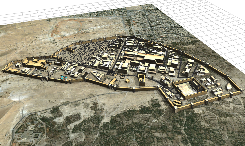
What originally began as a project to map out all damaged and at-risk heritage sites across the Middle East since the turn of the millennia developed into a focus on one of these such sites- that of Palmyra in Syria. This focus came about with my discovery of CityEngine and wanting to reconstruct the city as it was circa 300CE as a part of the Roman Empire at the time. I relied on primary and secondary literature, previously produced maps, and present-day imagery, as well as some artistic license where data was lacking in tandem with the software’s tools to gradually build the city. Over the course of almost 22 hours, I built the city through trial and error, which included hundreds of columns and the texturing process. Once completed, I produced a modern-day representation of an ancient city through the use of a 3D GIS program that would eventually allow people to see what it looked like before the city’s inhabitants moved away.
Seeing what could be accomplished with CityEngine, I later followed up Palmyra with my second and most complex ancient city yet- Constantinople circa 600CE. Following the same process as my first city but now with elevation and the circle polygon tool at hand, I gradually constructed this city over another 22 hours. This time however, several more hours were required for the texturing process due to the 8,000+ objects within the model. This eventually completed city portrays what Constantinople was like at this time compared to how the modern version of the city has expanded well outside of the former defensive walls. This city has most recently been accompanied by my third ancient city, Athens in 431BCE, which will stand in size between Palmyra and Constantinople. This city clearly demonstrates how Athens used to look almost 2,500 years ago, and how it has developed and expanded over time. For example, the Long Walls section connecting Athens proper and its harbour, the Piraeus, were torn down long ago but two city streets now run over the exact locations of these walls. It is details and visuals such as this that demonstrate how these 3D reconstructed cities can be used to show and teach people how our cities have and will continue to develop into the future.


This understanding has most recently been expanded to see to what extent I can reach people so as to be able to show them this aspect of human history. The two pictures below are of Constantinople and Athens in Google Earth after the idea was suggested to me after my GoGeomatics talk back in March. While there remains some bugs that need to be fixed, their importing into this widely available program is a resounding success that has demonstrated how GIS and 3D GIS programs can be used to recreate the past in order to preserve it in the present for our future to come.


Be the first to comment