Title: Canadian Cartographic Association (CCA) meets at the Centre of Geographic Sciences (COGS), Lawrencetown. May 30 – June 1st.
For the first time, the CCA is holding its annual meeting at COGS in Nova Scotia. There is a long history between these two parties. In the 1980’s COGS hosted two GIS Summer Institutes, supported by the CCA. At the beginning of the decade, NSLSI (now COGS) acquired new mini-computer technology. In the search for mapping software which would run on PRIME computer, we contacted Esri in California. We acquired both GRID and PIOS. Later, Scott Morehouse and Dave Bishop came up to install an early version of Arc/Info. This established the long term relationship between COGS and Esri.

Both Michael Goodchild and Roger Tomlinson came to Lawrencetown to participate in the GIS Summer Institute. Tomlinson was engaged with Ray Boyle to look at the redesign of the Cartography program.
This Summer, at the CCA meeting, Michael Goodchild will return as a keynote speaker, as well as Ken Field, Cartographer at Esri. COGS Cartography alumni Edie Punt and Clint Loveman will host mapping workshops on ArcGIS Pro and ArcGIS Maps for Adobe Creative Cloud. A third workshop in Open Source Web Mapping is available from Scott Emmons of UNBC.
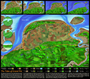
The other focus of the conference is community mapping. Marcel Morin, a COGS graduate, will describe his involvement in the UNESCO World Heritage site at Grand Pré and his work mapping with indigenous peoples of Canada. Ed Symons will present the results of the collaborative research with MapAnnapolis.

Map above designed by Marcel Morin – Lost Art Cartography
The presentation lineup includes a mix of technical, research and community focus with talks on topics such as the politics of mapping Wolastoqey Nation in New Brunswick, Indigenous Cartographies of Arctic Places and Spaces: A critical turn in the mapping of Greenland, A Biography of Robert Bell: On the Trail of the Great Stone Chief, Applications of 3D Printing in Physical Geography Education and Urban Visualization and so much more.
Preliminary details on the conference can be found on the CCA website. A more detail agenda will be available later in April.
What’s new in the Annapolis Valley?
If you have spent time at COGS in Lawrencetown, you should make a note of the new craft brewery (Lunn’s Mill Beer Company) and also the Beaver Creek Winery.
At the college, aside from the Walter Morrison Map Collection, you may be interested in the new program on Geospatial Data Analytics.
In Nova Scotia, as elsewhere in Canada, there is a renewed interest in mapping by the indigenous (Mi’kma’ki) community.
Registration is now open for the 43rd Canadian Cartographic Association conference, May 30 – June 2nd at the Centre of Geographic Sciences, Lawrencetown, Nova Scotia.
Not a member of the Canadian Cartographic Association but have a passion for maps and cartography? Not a problem … everyone is welcome!
CCA is a passionate group promoting interest in maps and cartographic material and creating opportunities to network and share ideas. If you have a passion for maps and community, join us Lawrencetown. We look forward to reconnecting with old friends of COGS, as well as recent graduates from Cartography programs across the country, and beyond.


Be the first to comment