
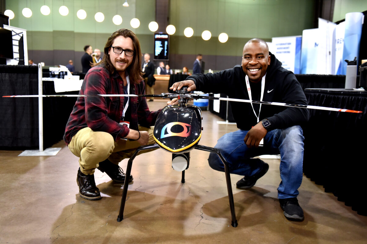
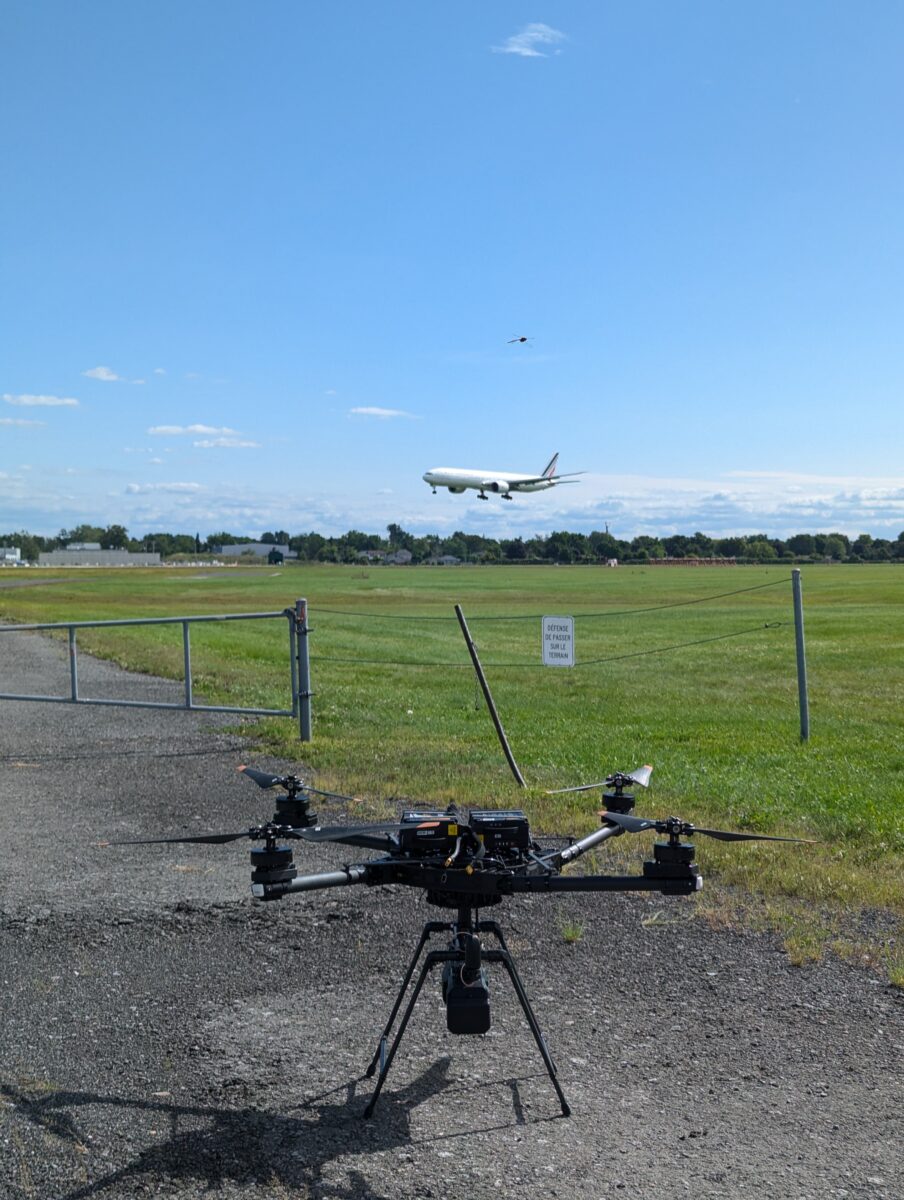
One of the most defining moments of Johnathan Smeh’s 10-year reality capture career was when he watched his drone fly adjacent to a taxing 737 passenger aircraft at Montreal’s international airport. It was not only his first project with Quebec-based Balko Technologies, it was one of the company’s most challenging and rewarding success stories featuring its drone modular sensor, Connectiv. One year since Connectiv launched, Geospatial Journalist Mary Jo Wagner sat down with Smeh at the recent GoGeomatics Expo to discuss how the market has reacted to the system, how they’ve managed skeptics, how the platform is disrupting certain markets, what’s driving sensor development, and why beaver dam mapping might be the next big thing in drone LiDAR.
Drones and LiDAR systems have had substantial growth but they’ve maintained growth in parallel — they’ve each stayed in their own application lanes, predominantly. How does combining the two approaches change the data capture game?
Traditionally, you have operators using one sensor type at a time. They fly a LiDAR or a photogrammetry sensor or a multi-spec depending on project need. But now with companies like Balko that are offering fully integrated RGB cameras into the LiDAR or multi-spec into the LiDAR, users can now address multi-faceted projects with one, modular system.
The integration of drones and LiDAR allows for a new level of efficiency and precision that previously would require multiple technologies. It really enhances surveyors’ capabilities, allowing them to offer highly detailed multi-dimensional data sets and expanding their potential services to clients. And it provides a competitive advantage, allowing them to improve data collection speed and accuracy for their projects, particularly for larger, complex data sets. Most importantly, integrating the technologies enables customers to reduce time and costs, giving them the ability to take on new work more quickly.
Since launching the first e-ONE modular LiDAR sensor in 2021, and then the next generation system, Connectiv, in 2023, what has been the overall reaction to the new modular platform?
We’ve had an overwhelmingly positive response, to be honest. The design is more user-friendly and we’ve created more modulars and more customization from our previous model, so we’re able to tailor our product to meet a more diverse set of needs for our clients. We’ve also upgraded it to having a rapid module swap connection.
Historically, geospatial users have applied a skeptical eye to new technology, particularly ones that are a significant leap from convention. Have you been met with the same skepticism about the Connectiv? What are users most unsure about?
Skepticism is natural, especially when we’re serving a traditionally meticulous field such as surveying and engineering. But our system hasn’t been met with overwhelming doubt mainly because we’re not reinventing the wheel with what we’re doing. We’re offering the ability to customize sensors as opposed to having model A, B or C, so all of our components, aside from our custom computer system module, are all industry-recognized, which really helps ease the client’s concern regarding our reliability and adaptability. We’re using drones and LiDAR sensors that many of our competitors are utilizing, but our differentiator is that our system is one modular unit.
I imagine you’ve had to do proof of concept projects to prove the system in a variety of different application areas. Is that the case and are you also challenged by the proliferation of consumer drones and operators who feel qualified to offer aerial surveys?
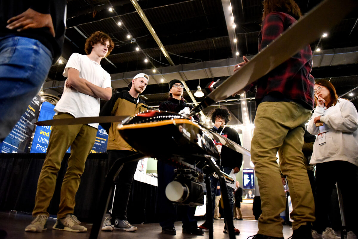
Yes and yes. Conducting demos is a lot of what I do. I go to different parts of the province or Canada primarily and show them how to use the system. They can touch it, feel it, kind of get a tactile understanding of what it’s about, how the workflow looks in the field, and then we sometimes will help them with a particular part of a project or something that they’re working on, provide them the data, and then do subsequent calls to discuss the data and then next steps as well. Typically, once I get to the demo stage, the Connectiv sells itself.
To your other point, the real low-cost, quick consumer-driven surveying is a real struggle and is very hard to compete with, particularly when you’re trying to explain to an uneducated person how their consumer-grade product isn’t going to provide the results they want. The product brochures are often super enticing and make it seem so easy and people don’t understand the complexities of producing a quality product. That’s been the theme of the drone industry though for a long time. I’ve been in the industry for over a decade and these are conversations we consistently have with potential new clients or even clients that we’ve had for years who’ve been burned by a drone provider. It does such a disservice and makes our job harder.
For those embracing the new approach, which application areas or industries are you finding the most interest for the Connectiv system, and why?
Government agencies are really embracing it. Organizations such as transport or hydro that need highly accurate and precise corridor mapping of roadways or hydroelectric lines have become consistent customers. We’ve done several projects with hydro companies as well as a couple of international airports that need 2-cm or better precision for runway, topography, and asset management scanning.
Because of the versatile nature of the product, we’re seeing a lot of interest from smaller to medium-sized businesses in the surveying and engineering markets. Both government agencies and commercial clients are finding the system is a solid return on investment because we can extend the lifespan to match an organization’s needs, adapting the sensors, modules, and upgrades as their business grows or their needs change. The modular nature of Connectiv also enables them to parse out the overall cost of the system as they acquire the modules they need as they need them, rather than having to procure the entire unit as one larger cost.
Apart from government and surveying and engineering, we’ve been approached with some rather inventive ideas. Someone familiar with our precision scanning capabilities asked me if we could use our system to help identify beaver dam locations in remote areas, which at the moment, is a time-consuming, boots-on-the-ground process. To map the dams, they have to send somebody out in the middle of the woods, with no trail, and up a river to try to find them and manually record locations. It’s extremely labor-intensive. With our system, you can easily optimize the sensor configuration best suited for that environment and safely scan areas-of-interest in minutes at centimeter accuracy. We’re hoping more of those unique opportunities lead to more established applications.
Balko’s initial objective was to develop a more affordable, accessible and flexible aerial data capture system for remote areas. What other factors have driven LiDAR sensor development both at Balko and in the RPAS space in general?
I would say it’s the demand for precise and high-quality data, which has really spurred a lot of innovation with the RPAS and the LiDAR technology. A lot of our clients now are starting to require data that meets strict RFP standards, which means that quality and precision are taking precedence over low cost in a lot of instances. As such, we’re focusing on developing these advanced, highly specialized systems that can support these kinds of applications in the field where data integrity is non-negotiable. That’s where we’re seeing success and a lot of innovation.
How do you see sensors further developing and what direction do you think advancement should take?
I could be completely wrong on this, but in my opinion, I feel like we’re reaching a bit of a plateau in some of the extreme accuracy and precision that we’re getting. We have sensors right now that are already achieving less than a centimeter, and it’s remarkable. So where do you go from there?
There are applications where you need more than that, but to me, those are quite niche. What I think we’re going to see is a movement towards cost reductions and accessibility, because we’re going to have more players enter the market in both manufacturing, individual components, and sensors themselves. And then service providers are going to buy this equipment more often. We’ve already seen over the last decade the cost of LiDAR sensors has come down enormously.
I think we’re also going to see more enhanced integration with data collection, onboard processing, and post-processing that’s going to integrate AI. With the proliferation of AI, providers have to find a way to make that work. We’re going to see a huge increase in efficiency like processing terrain models in a fraction of the time or classification in minutes as opposed to having to manually do that work. AI-driven products are going to save people time and money.
In which markets do you see a system like the Connectiv being the biggest disruptor and redefining business as usual?
That’s a good question. Honestly, I think it’s going to disrupt the small- and mid-sized surveying and engineering firms because right now a lot of them are still relying on traditional methods. Many of them are still working in grids capturing data with traditional handheld topography equipment. The day we start to see the point cloud LAS file become very prolific is when you’re going to see a lot of transformation in those sectors because they’re going to start to shy away from the industry standard of line work and spot elevations. There is always going to be a need for that type of work, but once you have most surveying companies on board with working with the point cloud, that’s going to be a game changer that will make them more comfortable with adopting a modular LiDAR solution like Connectiv.
What are some recent unique or challenging Connectiv projects you’ve done?
The Aerodrome Montreal airport for one. It was some of the most challenging and rewarding data collections that I’ve ever done. They are replacing their traditional surveying methods for collecting topography, infrastructure, and assets with LiDAR aerial surveys. They are progressive and embrace the technology because they see the value in the speed, efficiency, cost, and data detail provided in the point clouds and orthophotos. As a subcontractor on the project, we have been responsible for collecting that data. Although navigating the drone with air traffic control protocols and putting together the documentation has been meticulous and stressful, there is nothing like seeing your drone flying in the foreground as a 737 is landing in the background. It’s wild.
We have also worked with them on utilizing AI software to assist with data analysis for a project to collect a detailed LiDAR survey to map and detect cracks on a runway. We provided highly accurate LiDAR data and a very high-resolution ortho of one of the incoming runways, and for their analysis, they planned to use AI to identify where the cracks are to create a remediation and repair plan for the runway. It was a very interesting application.
What’s next for Balko and its modular LiDAR platforms?
We’re going to continue to lean into being the only provider with a modular LiDAR system in the market. And that means enhancing our products and continuing our innovation. So, we are expanding the offerings of our different modules, including finalizing some of the calibrations on a new Reigl unit. We’re also exploring different IMUs and camera models to offer more versatile hardware options and configurations as well as enhance our drone LiDAR software, e-LAS and also our tablet system that you connect to the platform. Customers have also been asking us for new platform integrations so over the next year, we’ll also explore those options. All of the improvements are designed to create ease and flexibility for customers.
Apart from improving our platform, we look forward to watching our customers and potential new ones amaze us with their creativity and imagination in using drone LiDAR. At least once a month I’ll have a conversation with somebody who presents me with a totally novel idea of data collection that I’ve never even thought of before. Like the beaver-dam example I mentioned earlier. It wouldn’t surprise me in the least if beaver dam identification via drones becomes a common application. People look at the technology, they see what it can do and they get inventive. It’s remarkable and I can’t wait to see more of it.
We can’t wait to see what’s next, too.


Be the first to comment