European Space Agency has finally unveiled the first images from Meteosat Third Generation-Sounder (MTG-S1), a satellite that doesn’t just watch the clouds—it “sounds” the atmosphere.
Launched in July 2025 and now fully operational, this newest generation of Europe’s geostationary Meteosat weather satellites is set to revolutionize how Europe predicts severe storms by mapping temperature and humidity in unprecedented detail.
Images Captured by the Infrared Sounder Instrument
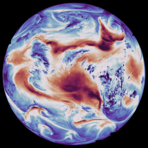
Taken with the satellite’s Infrared Sounder instrument using a longwave infrared channel, the first image shows temperature at the Earth’s surface and the top of the clouds. Warm areas are represented by red and cold areas are represented by blue with the warmest areas being over North Africa, and parts of southern Africa and Brazil. Areas of dark blue generally represent clouds.
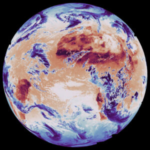
The second image shows the earth in terms of the atmosphere’s humidity with data captured using the Infrared Sounder’s medium-wave infrared channel. Blue areas represent high humidity and red areas represent low humidity. Areas of high humidity are clustered in eastern Africa and spread across the globe in high and low latitude regions. Areas of low humidity are shown over North Africa, the Middle East, and part of the southern Atlantic Ocean
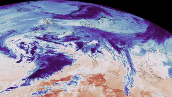
The third image, a close-up of Europe and northern Africa, also shows temperature data captured using the long-wave infrared channel. In this image a weather front can be seen in dark blue moving over Portugal and Spain.
How MTG-S1 is Adding a New Dimension to European Nowcasting
The Infrared Sounder’s capabilities are expected to transform the way that weather forecasting is done in Europe. The Infrared Sounder collects temperature and humidity data vertically as well as horizontally, and its hyperspectral sounding capabilities allow it to collect data on 1700 different infrared channels. This will allow scientists to create a three-dimensional map of the atmosphere which will greatly improve weather prediction and monitoring in Europe, especially in terms of nowcasting.
Nowcasting is weather forecasting done on a very short time scale ranging from mere minutes to a few hours and is crucial for dangerous events that can evolve quickly like severe thunderstorms and flash floods. The MTG-S1 collects new measurements over Europe every 30 minutes, meaning that authorities will be able to get near real-time updates on dangerous weather systems and give more advanced warnings to the public, potentially saving lives.


Be the first to comment