
How changing international relationships create new opportunities for technical collaboration
Last year, in my keynote at GeoIgnite 2025, I spoke about how Canadian geospatial innovations can tackle environmental problems. I mentioned, for instance, RADARSAT’s Arctic monitoring capabilities, SmartICE’s integration of traditional knowledge with satellite data, along with precision agriculture optimizing farm operations across the Prairies.
The technology keeps moving forward, but what stands out to me now is how the international partnerships around it are changing. Listening to the Davos speech of Prime Minister Mark Carney, it felt like a follow-up of words I’ve been hearing in conversations since last year’s Ottawa conference. Canada is reaching out to Europe for new technical collaborations, while North American data-sharing routines feel less certain.
For those of us heading to GeoIgnite 2026, these changes will shape our work in the years to come. We will still need to access data, find funding, set standards, and build partnerships, but in a rapidly changing international landscape. Understanding this new situation is how Canadian geospatial work will stay relevant.
Arctic Monitoring: Technical Requirements Meet Partnership Opportunities
Preliminary RADARSAT data from the 2025-2026 winter shows Arctic sea ice declined about 13% compared to the previous year. More open water means a longer navigation season. Canada needs better monitoring capabilities in the Northwest Passage to track the increased activity.
SmartICE now operates in 30 Arctic communities, combining Inuit knowledge with satellite data for local ice safety. Expanding this to broader maritime monitoring requires predictive modeling, automated vessel detection, and integration across multiple sensor types.
European partnerships provide useful models. The Dutch TROPOMI instrument works with Canadian radar satellites to monitor Arctic air quality. The Arctic Spatial Data Infrastructure links mapping agencies from eight nations, though maintaining coordination takes sustained diplomatic effort.
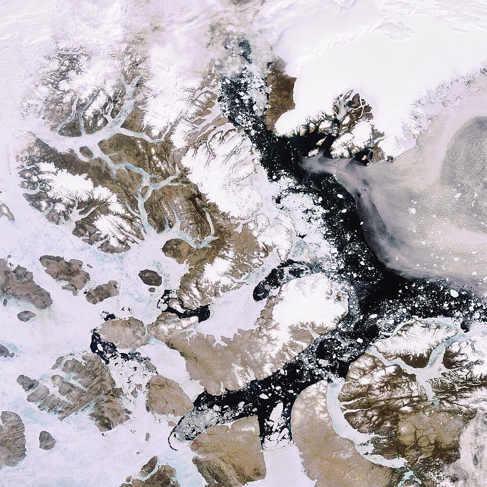
Canada’s participation provides opportunities for technical leadership in standardizing Arctic monitoring approaches, particularly as various nations develop overlapping coverage in the region.
Data Sharing: Adjusting to a New Reality
Cross-border environmental monitoring has historically assumed relatively uninterrupted data exchange between Canadian and American agencies. Great Lakes monitoring, agricultural research collaborations, and integrated environmental evaluations benefited from this arrangement.
Recent policy developments in Washington, D.C., affect these relationships. Reduced data sharing affects operational systems. Precision agriculture companies face supply chain uncertainties. University partnerships require more careful structuring.
This is a moment to look for new partners and rethink where to put your energy.
Canada’s 2024 Horizon Europe association agreement entered into force in 2025. Canadian researchers and companies now have equal access to €95 billion in European collaborative research funding. This isn’t observer status—it’s full participation in EU research programs.
The EU-Canada Green Alliance funds net-zero technology work, ocean sustainability projects, and secures critical minerals for sensors and batteries. For Canadian geospatial professionals, this opens up European funding for Arctic research they couldn’t access before. Dutch water management experts can now work on Canadian coastal monitoring challenges. German sensor technology gets adapted to work in Canadian conditions.
You’re not replacing partnerships that function well. You’re adding backup options for when the usual routes hit roadblocks.
Environmental Intelligence Systems: Technical Evolution
Here’s the geographer’s view about environmental problems: they all happen somewhere specific. Deforestation destroys particular forest stands. Heat islands form in certain neighborhoods. Drought hits one watershed while the next one over stays wet.
If you don’t know where a problem is, you can’t fix it. Geography isn’t background information. It’s the foundation.
Canada’s boreal forest monitoring through the Virtual Forest system can now tap European funding for machine learning improvements. Indigenous communities use it to document cultural landscapes. Companies plan sustainable operations with it. Conservation groups identify wildlife corridors.
Precision agriculture is advancing fastest where the need is greatest—the drought-prone Prairies. Wageningen University and the University of Saskatchewan ran field trials combining satellite data with soil sensors. The results showed water savings of about 25%. Farmers are using these systems now on working farms. They help with both climate adaptation and the bottom line.
Montreal and Vancouver run urban monitoring platforms that combine climate vulnerability mapping with infrastructure resilience planning. Rotterdam and Amsterdam provide working examples. The EU-Canada Security and Defence Partnership sets up frameworks for sharing these technical approaches.
Indigenous-Led Innovation: Governance and Technology
The most meaningful geospatial innovation often comes from the people who live with environmental change every day.
SmartICE shows what happens when you combine Inuit knowledge about ice with satellite data and modern sensors. The result works. Communities get jobs. Traditional knowledge is respected rather than ignored. People actually use the tools.
First Nations communities across Canada are developing their own versions. Europe’s ocean monitoring programs might offer partnership opportunities down the road. But here’s the non-negotiable part: Indigenous communities decide how their data gets used. Period.
I mean real control, not the usual consultation theater where decisions are already made, and communities get asked for input. Indigenous knowledge belongs to Indigenous communities. They determine who accesses it, how it’s shared, and what happens to it. That needs to be settled before any partnership discussions start.
In my diplomatic work, I learned that data governance matters just as much as the technology collecting it.
What This Means for Your Work
If you’re building government monitoring systems, think about where your data comes from. European satellites can back up the systems you already rely on. Redundancy matters more now than it used to.
Agriculture technology companies might find European sensor partnerships more attractive as supply chains shift. The Wageningen collaborations show this can work—proven results, compatible regulations, fewer headaches.
Urban resilience planners should examine how Rotterdam approaches climate adaptation. Combine that with Canadian digital twin work, and you’ve got something other cities will pay for.
Indigenous programs need data sovereignty frameworks built in from day one, not added later. European funding sources often respect Indigenous governance better than some alternatives, but you have to set those boundaries early.
And if you’re developing standards, push for Pan-Canadian frameworks built on OGC and BIM specs. Systems that work independently matter more when you can’t count on everyone playing nice.
The Work Continues
Geopolitics shifts. The environmental work doesn’t stop. Arctic ice keeps melting. Forests need management. Prairie farmers face drought. Cities deal with heat and flooding.
Canada’s geospatial community has built real strengths in all these areas. Reaching out to Europe brings in new resources and partners, and it means we’re not putting all our trust in just one relationship.
The technical work goes on, and our options for partnership are wider than ever. As we look ahead to GeoIgnite 2026, the challenge is to make the most of these new opportunities while staying true to the core mission: building the geospatial systems Canada needs to care for its land and future.
The technical work hasn’t stopped. Partnership options keep expanding. Canada’s geospatial community has built strong capabilities over the years in solving tough problems. Now there are more ways to collaborate, more funding sources to tap, more expertise to share.
The challenge is using these new opportunities without losing sight of what matters: building the intelligence systems Canada needs to protect its environment and plan for a sustainable future.
Alexander Verbeek is a geographer, former Dutch diplomat, and journalist, focusing on environmental security, and is currently based in Oslo, Norway. He spoke on this topic in a keynote address at GeoIgnite 2025 in Ottawa.


Be the first to comment