
Industry Perspective
Executive Summary
- The Challenge: Turning the growing volume of geospatial information into timely, usable insight.
- The Solution: Agentic AI platforms like GeoAgent that integrate adaptive reasoning with scientific remote sensing.
- The Impact: Shortening the path from raw imagery to operational intelligence across multiple sectors.
For decades, the geospatial industry has focused on improving how we collect data. Sensors have become more capable; satellites are more numerous, and aircraft-based mapping systems are more precise. Today, organizations routinely gather imagery and spatial data at scales that would have once seemed impossible. But as collection technologies have advanced, a new challenge has emerged: turning the growing volume of geospatial information into timely, usable insight.
Across government agencies, commercial industries, and defense organizations, analysts often find themselves managing terabytes of imagery while navigating complex software workflows, leaving valuable insights locked behind technical barriers. The imbalance between data availability and analytical capacity is becoming one of the defining challenges of modern geospatial operations.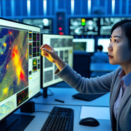
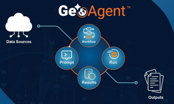
A new generation of systems is beginning to address this problem by combining artificial intelligence (AI) with domain-specific geospatial expertise. One example is GeoAgent, an agentic AI platform developed by NV5 that integrates adaptive AI reasoning with scientific remote sensing analytics of the ENVI® platform.
Rather than requiring users to manually configure complex workflows, GeoAgent interprets the user’s objective, plans the analytical steps required to achieve it, and executes the process automatically while maintaining full transparency. The result is a different model for geospatial analysis. One that shortens the path from raw imagery to operational insight.
A New Approach to Geospatial Automation
Traditional automation in geospatial analysis has largely focused on individual algorithms. Machine learning models might classify land cover, detect objects in imagery, or identify patterns in spectral data. However, the responsibility for designing and managing the workflow typically still falls on analysts.
“Instead of executing isolated algorithms, an agentic system reasons through a task, determines which analytical steps are required, sequences those steps automatically, and adapts as conditions change.”
Agentic AI changes that. Instead of executing isolated algorithms, an agentic system reasons through a task, determines which analytical steps are required, sequences those steps automatically, and adapts as conditions change.
GeoAgent applies this concept directly to geospatial analysis. Users interact with the platform through a conversational interface, describing the question they want answered or the outcomes they need to achieve. GeoAgent then identifies the appropriate tools, performs the required processing steps, and generates outputs that can be integrated directly into operational systems.
Every action is recorded, including the parameters used and the analytical steps performed. This creates a transparent and reproducible record of the analysis so organizations can justify decisions or maintain audit trails. The platform is built on the Model Context Protocol (MCP), allowing it to exchange information with other AI agents and analytical tools. This architecture enables GeoAgent to operate as part of a larger ecosystem of interoperable systems rather than as a standalone application.
Expanding Access to Geospatial Insights
Remote sensing workflows often require deep technical knowledge which has created a centralized concentration of expertise in a small group of specialists. GeoAgent helps address this challenge by supporting both technical and non-technical users.
Less experienced users can interact with the system using natural language instructions, describing outcomes without specifying the analytical tools required. GeoAgent determines the appropriate processing steps and summarizes the results in clear, understandable terms. Experienced analysts can use the same system to automate repetitive tasks, accelerate complex workflows, and explore additional data sources without manually configuring each step.
Applications Across Key Industries
The practical implications of this approach become clearer when looking at how agentic geospatial systems can support real-world missions across multiple industries.
Transportation Infrastructure
Transportation agencies increasingly rely on geospatial data to monitor infrastructure networks, assess environmental conditions, and plan future development. GeoAgent can analyze time-series imagery to detect changes along transportation corridors, identify construction activity near critical infrastructure, or monitor environmental conditions that may affect roadways and rail networks.
For example, transportation planners might ask GeoAgent to evaluate recent land-use changes near a proposed highway expansion. GeoAgent can retrieve relevant imagery, classify land cover, detect recent development activity, and generate outputs that support decision planning. By automating these workflows, agencies can move more quickly from data collection to actionable insight.
Utilities and Network Operations
Utilities operate some of the most extensive and distributed infrastructure networks, often spanning thousands of miles and multiple jurisdictions. Maintaining visibility into these assets while tracking condition, change, and risk, can be a complex and resource-intensive task.
GeoAgent can integrate imagery, lidar, and historical datasets to identify and extract infrastructure such as poles, lines, substations, and other network components. It can then monitor change over time, detect potential risks, and generate structured outputs that integrate directly into asset management and operational systems.
For example, a utility operator might ask the system to identify areas where vegetation encroachment has increased along a transmission corridor or to extract and validate asset inventories from newly collected data. GeoAgent can retrieve relevant datasets, apply detection and classification workflows, and publish results that support maintenance planning and system reliability. By automating these processes, utilities can shift from periodic, manual assessments to more continuous, data-driven network management.
Climate and Environmental Monitoring
Climate monitoring has become one of the most data-intensive applications of remote sensing. Satellite imagery and airborne sensors are routinely used to track changes in vegetation, monitor coastal erosion, and measure the impact of extreme weather events.
GeoAgent can assist environmental scientists by automating the retrieval and analysis of historical imagery across multiple time periods. This allows researchers to quickly identify long-term trends in land cover, water levels, or ecological conditions.
For example, in coastal environments GeoAgent can analyze shoreline changes over time, identify areas vulnerable to erosion, and generate spatial datasets that support climate resilience planning. By reducing the time required to process large imagery archives, this allows researchers to focus more on interpreting environmental changes rather than preparing data.
Emergency Response and Disaster Management
In disaster situations, the ability to rapidly interpret geospatial information can directly affect response effectiveness. GeoAgent can compare imagery capture before and after an event to identify flood extent, infrastructure damage, or blocked transportation routes. The system can then intersect these results with road networks and publish the findings directly into operational GIS environments used by emergency management teams. This capability allows response agencies to gain situational awareness quickly and coordinate resources more effectively during rapidly evolving events.
Defense and Mission Support
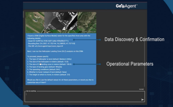
Defense organizations rely on geospatial analysis to support operational planning in complex environments. Agentic systems can assist by evaluating terrain conditions, identifying suitable landing zones, or assessing route suitability across challenging landscapes. For example, GeoAgent can analyze elevation models, vegetation cover, and line-of-sight conditions to identify potential helicopter landing areas within a specified region. The results can be delivered as geospatial layers and annotated imagery that support mission planning. By automating these analytical steps, mission support teams can generate situational awareness products in minutes rather than hours.
Integrating Geospatial Intelligence into Operations
One of the most important aspects of agentic systems like GeoAgent is their ability to integrate with existing enterprise environments. Rather than replacing established geospatial tools, GeoAgent orchestrates them. This approach also avoids the constraints of vendor lock-in. Many AI platforms require organizations to operate within a single software ecosystem, limiting flexibility as data sources, tools, and requirements evolve. GeoAgent is designed to work across environments, integrating with existing geospatial systems, data platforms, and analytical tools. This allows organizations to preserve prior investments while maintaining the freedom to adapt their technology stack over time.
The platform works with a wide range of data types (e.g. optical imagery, hyperspectral data, synthetic aperture radar (SAR), and vector information) and publishes results directly into GIS platforms and operational systems. This ensures that analytical insights go beyond the desktop environment and into workflows where decisions are actually made.
The Next Phase of Geospatial Insights
Agentic AI represents an important step in the ongoing evolution of geospatial technology. Future systems will likely combine these capabilities with additional innovations such as generative models for scenario stimulation, graph neural networks for analyzing spatial relationships, and hybrid AI approaches that combine machine learning with logical reasoning. These advances will allow geospatial systems to not only analyze past and present conditions but also to simulate potential future outcomes.
GeoAgent is at the forefront of this new generation of AI, and an early example of how these systems can operate in real-world environments. Combining adaptive AI with scientifically grounded remote sensing analytics enables organizations to process geospatial data more efficiently, share insights more broadly, and move more quickly from information to operational intelligence.
To learn more about GeoAgent, visit www.NV5.com/GeoAgent.


Be the first to comment