
The World Geospatial Industry Council (WGIC) kicked off its annual Horizons 2025 event in Denver with a powerful lineup of thought leaders, industry experts, and innovators all focused on the evolution of geospatial technologies and their impact on global challenges. The conference highlighted how geospatial data, artificial intelligence (AI), and Earth Observation technologies are reshaping industries from construction to climate resilience.
Opening Address: A Landmark Year for WGIC
The event was officially opened by Bryn Fosburgh, President of WGIC, who set the tone for the conference by emphasizing the council’s mission to expand the value of geospatial and EO data and technologies. He noted that this year is crucial for WGIC as it focuses on strengthening advocacy, creating new business opportunities, and fostering deeper networking connections for its members.
In his address, Bryn also acknowledged the transformative role emerging technologies like AI, machine learning, and mobile mapping are playing in reshaping the geospatial industry. He pointed out how sectors such as construction, agriculture, and mining are increasingly leveraging geospatial technologies to solve real-world challenges. He also touched upon the need for evolving data storage practices and privacy considerations to ensure sustainable industry growth.
Harnessing AI and Digital Twins for Geospatial Workflows
Sean Young, Director of Geospatial and AI Solutions at NVIDIA, took the stage next to explore how AI is poised to revolutionize geospatial workflows. Sean provided insights into various AI solutions, including generative AI, machine learning, and digital twins. He discussed how these technologies are enabling the aggregation of geospatial data and creating synthetic data to simulate projects before they are deployed in the real world. He emphasized that AI’s role in the geospatial sector is not only about efficiency but also about creating more intelligent, data-driven decision-making processes.
Technology and Innovation in Construction
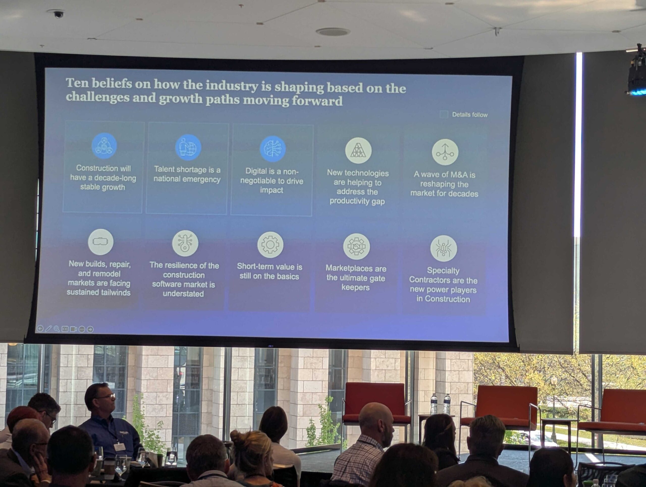
The construction industry has been experiencing a technological revolution, and José Luis Blanco, Senior Partner at McKinsey & Company, provided an in-depth look at how AI, robotics, and autonomy are reshaping the industry. José highlighted the growing use of drones, wearable tech, and prefabrication in construction, all of which improve safety and project efficiency. Despite these advancements, he pointed out challenges like high costs, regulatory hurdles, and workforce adaptation. He emphasized that the coming years will be pivotal for overcoming these barriers and fully realizing the potential of these innovations.
Generative AI in Geospatial Use-Cases
Kate Zimmerman from AWS shared her expertise on how generative AI is transforming geospatial workflows. She presented real-world case studies that showcased how AI is being deployed at scale in earth observation and multi-analytics domains. Kate’s talk concluded with a look at the evolving landscape of generative AI and its potential to revolutionize the geospatial sector by enhancing capabilities in mapping, modeling, and data analysis.
Geospatial + Cloud: Where Cloud Meets the Ground
Jefferson Wang, Chief Strategy Officer of Cloud First at Accenture, led an engaging discussion on how geospatial data is becoming increasingly ubiquitous through satellite imagery, sensors, and mobile devices. He emphasized the crucial role of cloud technologies in processing and actioning this data, turning it into actionable insights rather than mere noise. Jefferson’s session highlighted the powerful combination of geospatial data and cloud infrastructure, paving the way for smarter, data-driven decision-making in industries across the world.
Nadine Alameh on Building a More Efficient Geospatial Ecosystem
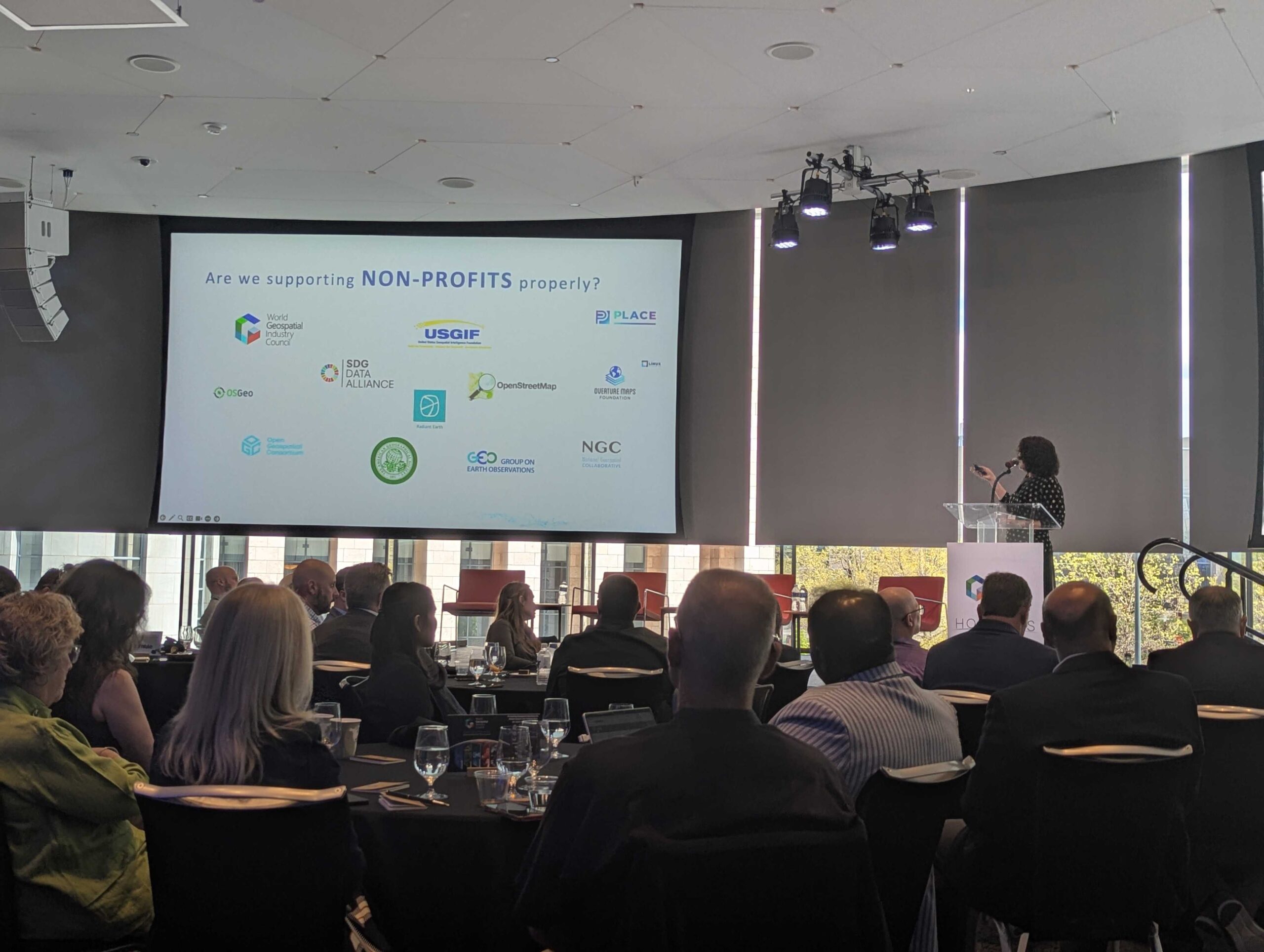
Dr. Nadine Alameh, Executive Director of the Taylor Geospatial Institute, captivated the audience with her observations on the evolution of the geospatial ecosystem. She discussed how national mapping agencies, academia, research organizations, and non-profits need to collaborate more effectively to tackle pressing issues like climate change, food security, and sustainability. Nadine’s message was clear: the geospatial community must bridge the gap between research and real-world solutions by fostering collaboration and breaking down silos.
AI and Business Growth with Microsoft
In a session led by Eve Psalti, Senior Director of Artificial Intelligence at Microsoft, attendees learned about the transformative potential of generative AI and machine learning for business growth. Eve delved into Microsoft’s AI innovations, including tools like Copilot and Azure OpenAI Service, and how they are streamlining business operations, enhancing productivity, and shaping the future of work. She also touched on the responsible AI framework that Microsoft advocates, emphasizing transparency and governance.
Geospatial Analytics and Water: A Critical Intersection
As global water challenges grow, Will Sarni , Practice Lead, Water and Nature, Water Foundry an Earth Finance Company, presented a session on the intersection of geospatial analytics and water management. He explored how geospatial data and GIS technologies can help mitigate water risk and improve water management practices, offering a strong business case for the adoption of GIS in addressing water-related challenges.
Geospatial Innovation for Climate-Resilient Cities
The day concluded with Andy Deacon from the Global Covenant of Mayors for Climate & Energy (GCoM) discussing how geospatial innovation can contribute to creating climate-resilient cities. His session highlighted the vital role that geospatial technologies play in addressing urban challenges like climate change, resource management, and disaster resilience, offering actionable insights into how cities can leverage geospatial data to build more sustainable futures.
The first day of Horizons 2025 event provided a comprehensive look at the dynamic, ever-evolving world of geospatial technologies. From AI advancements to digital twins and cloud solutions, the discussions emphasized how geospatial professionals must adapt to a rapidly changing landscape. As WGIC continues to advocate for the geospatial community, the event underscored the importance of collaboration, innovation, and data-driven decision-making in tackling some of the world’s most pressing challenges.


Be the first to comment