
The ocean is still mostly unmapped. Canada’s coastline is the longest in the world. And the future of maritime safety, trade, climate monitoring, and Indigenous collaboration rests on how we fill those gaps — not just with data, but with purpose.
That was the powerful message delivered by Manon Larocque, Hydrographer General of Canada, in her keynote at GeoIgnite 2025. As head of the Canadian Hydrographic Service (CHS), Larocque took the audience deep into the realities of modern hydrography, the evolving role of her department, and the digital transformation sweeping through Canada’s marine geospatial landscape.
Larocque opened by reframing what hydrography means today. It’s no longer just about nautical charts and navigational safety –though that remains a cornerstone. Instead, CHS is now a critical enabler of climate resilience, environmental stewardship, marine economy planning, and Arctic sovereignty.
“Water is our connector. It’s our future,” she said. “And we are committed to modernizing how we map, share, and use hydrospatial data across Canada’s vast and dynamic waters.”
From Paper Charts to AI-Powered Insights
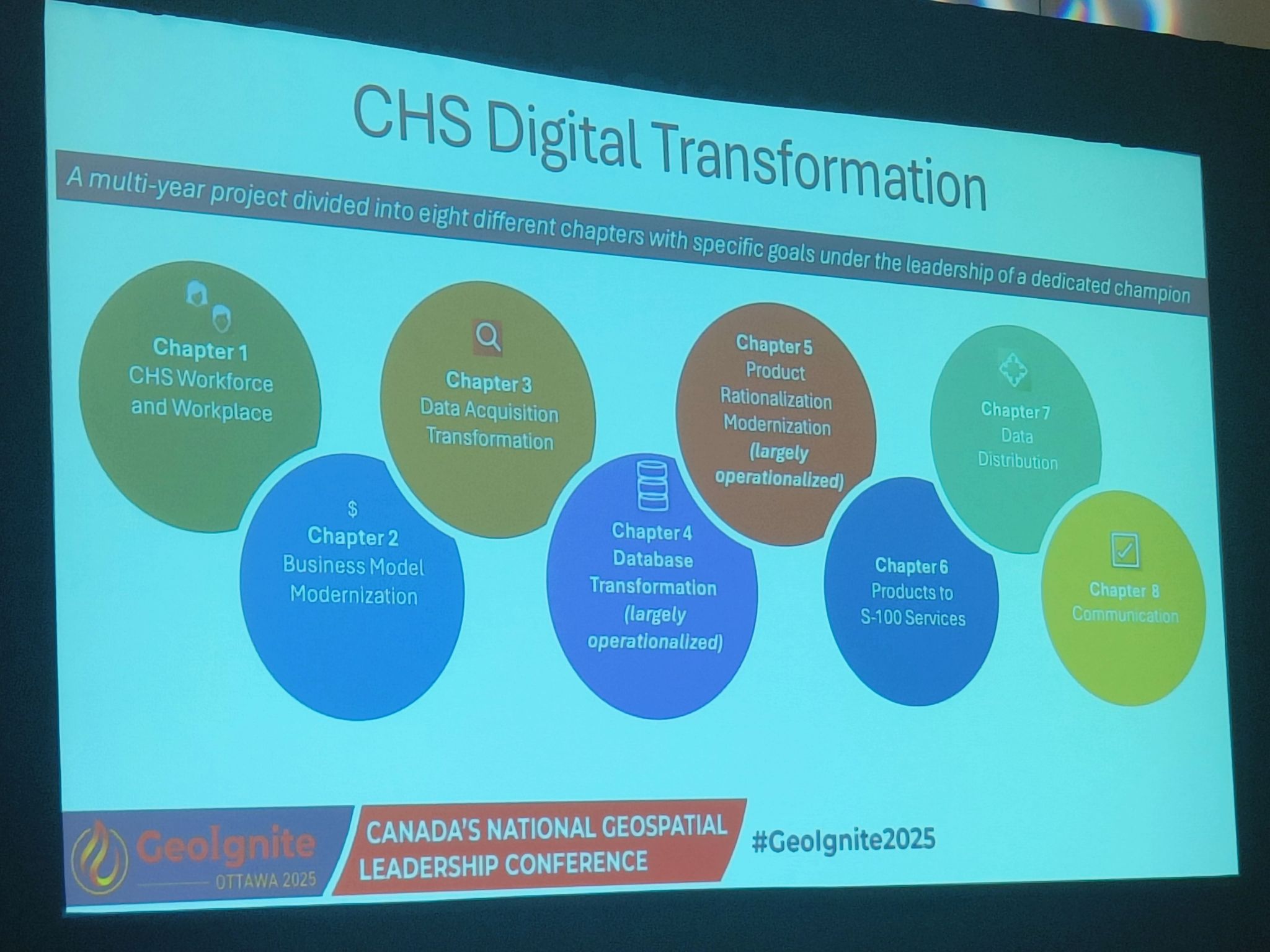
The CHS is currently undergoing one of the most significant digital transformations in its history. Larocque highlighted several key areas of progress:
- Adoption of the S-100 standard: Enabling next-generation electronic navigational charts with richer, interoperable data.
- Use of satellite-derived bathymetry (SDB): Increasing coverage in hard-to-access coastal and Arctic zones.
- AI tools for data processing and classification: Enhancing speed and consistency across mapping workflows.
- Transition from legacy systems: Moving away from paper-based and analog processes toward integrated platforms that connect with broader national and international marine data systems.
Canada is the first nation to offer the full S-100 Phase 1, providing vital navigational data like water levels, currents, navigational warnings, and high-resolution bathymetry. Endorsed by the International Hydrographic Organization (IHO) and in partnership with the Canadian Coast Guard (CCG), these trials will deliver real-time S-100 data along a 350-km stretch of the St. Lawrence Waterway, running from June 1st to November 30th, 2025.
Serving Safety, Sustainability, and Sovereignty
Throughout her presentation, Larocque emphasized that CHS is not only modernizing for the sake of efficiency—but to better serve Canadians.
- Marine safety: Supporting commercial shipping, recreational boating, and emergency response with up-to-date, high-resolution data.
- Climate resilience: Feeding hydrospatial data into models for storm surge, sea level rise, and coastal erosion.
- Economic growth: Enabling ocean-based industries to plan, build, and operate sustainably.
- Arctic presence: Expanding mapping efforts in northern regions to support infrastructure, Indigenous communities, and environmental monitoring.
Larocque also spoke with pride about CHS’s growing partnerships — not just within government, but with academia, Indigenous nations, and international counterparts. She highlighted Indigenous hydrography initiatives as a vital part of Canada’s reconciliation journey, noting that co-developed knowledge systems are helping redefine how and why we map water.
Manon Larocque’s keynote was a declaration that Canada is positioning itself as a global leader in hydrospatial intelligence. But leadership, she reminded the audience, means not only innovation, but accessibility, ethics, and long-term vision.
As she put it: “We are charting new waters — literally and figuratively. And we need everyone at the table to do it right.”
Key Takeaways:
- CHS is embracing AI, open standards, and satellite technologies to modernize hydrography.
- Hydrospatial data is now central to climate action, maritime safety, and Arctic sovereignty.
- Collaboration with Indigenous communities is helping reshape Canada’s marine data governance.
- The shift to S-100 and digital-first workflows positions Canada at the forefront of global marine geospatial innovation.
Manon Larocque’s keynote showed what happens when a legacy institution redefines itself for a new era—one where water is more than a boundary. It’s a bridge to Canada’s future.


Be the first to comment