
The Canadian geospatial and engineering sectors are at a crossroads — and we need space for real conversation. GoGeomatics is proud to announce the return of the Canadian Geomatics & Geospatial Advisory Forum, launching its second edition at GoGeomatics Expo 2025 taking place in Calgary November 3-5. Following a successful debut at GeoIgnite in Ottawa earlier this year, the Forum is once again inviting invites the Canadian geomatics and engineering community and stakeholders to engage in honest, practical dialogue on the future of the sector.
Date: November 3, 2025
Location: Calgary, Alberta
Format: Free, open, and national in scope
A National Conversation — Open to All
Held the day before the Expo officially begins, this is a free, inclusive event designed to welcome everyone — whether you are in government, private industry, academia, non-profits, or simply passionate about the field.
It’s Canada’s only vendor-neutral national forum for the geomatics and geospatial community. A place where anyone can:
- Share ideas and concerns
- Raise key questions
- Reflect on national priorities
- Offer a voice on what leadership, innovation, and coordination should look like

The Format
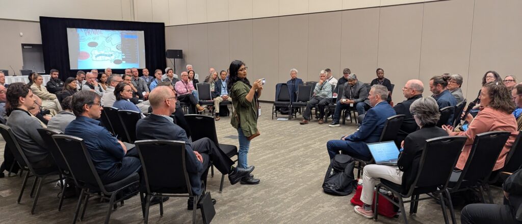
- Forget stages and slide decks. The Forum is built around open, moderated discussions designed to surface the key challenges and opportunities shaping Canada’s geomatics future.
- Participants gather in a circle—no podiums, no hierarchy—where every seat is equal and every voice counts.
- Discussions are topical, relevant, and grounded in the present, focused on real-world issues facing the sector today—many of which are overlooked in traditional conference settings.
- The goal is to foster insight, reflection, and shared direction through authentic, inclusive dialogue.
What’s on the Table
This Forum offers space to explore critical themes shaping Canada’s geomatics future, including:
- National geospatial and data policy
- Public investment and procurement practices
- Talent development, education, and occupational classification
- Government-industry-academic coordination
- Security, digital sovereignty and self-reliance
Get Involved
We’re actively looking for:
- Sponsors who want to support open, independent sector dialogue
- Participants who bring grounded insight and fresh perspectives
- Organizations interested in submitting discussion topics or ideas
At the end of the session, a summary report will capture the key takeaways and insights to help inform future programming and conversations across the country.
If you believe Canada needs a stronger, more connected geomatics and geospatial sector—this is your opportunity to contribute.
To participate, sponsor, or submit a topic idea, contact:
[email protected]
Learn more at: GoGeomaticsExpo.com
GeoIgnite Open Forum
Prominent among the list of attendees:
- Will Cadell, Founder & CEO, Sparkgeo
- Prashant Shukle, Board Chair OGC
- Susan Muleme Kasumba, Director, Business Development, Airborne Imaging Inc.
- David Gachuche, Founder & CEO, RiverCross Technologies
- Denis Hains, President & CEO, H2i
- Paula McLeod, Technical Advisor, Geological Survey of Canada
- Yasmine Boilard, GIS Analyst, BC Gov
- Bilyana Anicic, CEO, Aurora Consulting
- Peter Rabley, CEO Open Geospatial Consortium
- William Blahut, Policy Analyst, Canadian Space Agency
- Mathieu Primeau, Senior Customer Success Manager – Federal Government, Esri Canada
- John Campo, Team Manager GIS, Dillon Consulting Limited
- Nicolas Arellano, Architect, PhD Candidate, Research team lead, Carleton Immersive Media Studio (CIMS)
- Marikka Williams, GIS Professor, British Columbia Institute of Technology (BCIT)
- Kelly Seguin, GISP, GIS Specialist, City of North Bay
- Alain Gauthier MSC, CD, ICF-PCC, ICC-Master Coach, Strategic Advisor in Leadership and Organizational Strategy, Senior Officer | Retired – CAF
- Neil Spooner, Director, National Capital Region, Esri Canada Limited
- Catherine Robin, Acting Director, Canadian Geodetic Survey, Natural Resources Canada
- Nicholas Weishaar, Senior Planning Advisor, Department of National Defence
- Stephanie Tubman, Team Leader, DND – Mapping and Charting Establishment
- Joe Philbrook, VP, Customer Success, Customer Delivery & Operations, Archistar Pty Ltd
- Carlos Rojas, INEGI
- Shane Long, Director, Community Maps, Esri Canada
- Gordon Plunkett,Director SDI, Esri Canada
- Alex Aurica, Coordinator, Environmental Science Integration and Standards, Ontario Public Service
- Vernon Singhroy, President, EOSPATIAL Inc
- Paula Gomez, eTraining Expert, Global eTraining
- Sylvie Daniel, Full Professor, Université Laval
- Steve Slusarenko, Director, Subsurface Utility Map Data Exchange (SUMDEx)
- Richard Estephan, Senior Director, Open Geospatial Consortium
- Ted MacKinnon, Senior Geomatics Technologist, Natural Resources Canada (NRCan)
- Glenn Stowe, Co-Founder/Vice President, CubeWerx
- George Gaeke, Land Use Planning & GIS Instructor and Researcher, Olds college
- Luc Vaillancourt, Founder, Geospatial Industry Strategist, BALIZ
- Gordon McElravy, Director, Industry Council Program, buildingSMART Canada
- Anudeep Bildfell, Calibration and Validation Scientist, Wyvern Inc
- Terry Aucoin, President, OnPar Solutions
- Kevin Jones, Vice President, Product, CATALYST, PCI Geomatics
- Vandit Pathak, VDC Coordinator, EllisDon Construction, Virtual Design Construction
- Louis-Martin Losier, Senior Product Manager, Bentley Systems
- Sam Lieff, VP of Sales, EarthDaily
- Michael Claassen, VP of Innovation at Spexi, Spexi Geospatial
- John Roos, Senior Sales Director, Maxar
- Stephanie Tubman, Team Leader, DND – Mapping and Charting Establishment
- Dale Nicholson, President, Canadian Hydrographic Association
- Stephen Fai, Director / Professor, CIMS
Our Sponsors
Platinum Sponsor
Gold Sponsors

Silver Sponsors


Bronze Sponsors


Be the first to comment