
Mapping Canada’s carbon landascape
WWF-Canada has conducted new research with the lead of McMaster University’s Remote Sensing Lab scientists to measure the stored amount of carbon in Canada’s landscape. The findings show that stored carbon is equivalent to nearly 30 years of human-caused global greenhouse gas emissions at 2019 emission levels. Check out the interactive carbon map here to find how much carbon is stored in a particular part of Canada.
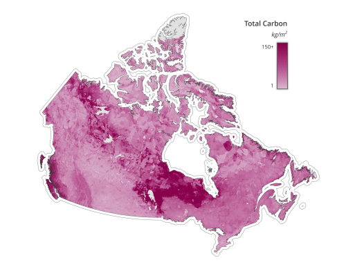
The results of this study have important messages for Canada and the world. High-carbon regions require more attention to ensure the notable amount of stored carbon does not release back into the atmosphere. Nature-based climate solutions (NbCS) will help the stored carbon remains locked in nature and raise the chance of future absorption. NbCS not only help us tackle climate change but provide crucial habitat for wildlife, especially for at-risk species.
Read more details about Canada’s first-ever national carbon map here
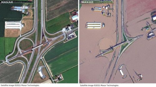
Before-and-after satellite images show flood devastation in B.C.’s Sumas Prairie
Two weeks ago, east of Abbotsford’s town centre experienced massive flooding. This low-lying rural area which is mostly farmland was formed by the draining of Sumas Lake in the 1920s. The flood was caused by water flowing from the Nooksack River from neighbouring Washington state. Evacuations and killed livestock were the consequences of this devastating flood.
The flood and following storm submerged many houses, barns and roads. The satellite images below by Maxar Technologies show farmland and highway roads in Sumas Prairie, B.C., on June 27, left, and November 19. See more of the flood damage in the region here.
The Royal Canadian Geographical Society awards 18 medals to outstanding individuals
On November 17, the Royal Canadian Geographical Society presented awards to a group of people who made a special impact in 2021 in the fields of geography, education, science and exploration, and volunteered to help the Society. The achievements of the 18 awarded individuals make Canada better known to Canadians and the world.
This year’s awards have gone to an extraordinary group of people, from artists to educators to scientists. We are honoured to bestow recognition upon each of these individuals for their outstanding work in their fields and for their dedication to the Society and the discipline of geography.
John Geiger, Chief Executive Officer of the Royal Canadian Geographical Society
Read more about these 18 awarded individuals and their outstanding achievements here
Asset-Mapping Helps Telecommunications Firm Bring High-Speed Internet to Rural Communities
Due to the costs of implementing High-speed internet for rural and remote communities, introducing Fiber to the Home (FTTH) to these communities is a challenge. One of the expenses of investing FTTH for lower population densities is collecting the required infrastructure data for planning networks. Field crews gathered utility pole asset data with GPS tools, laser distance sensors, paper drafts and surveyor’s wheels. Inaccuracy or missing information are the challenges of these traditional methods.
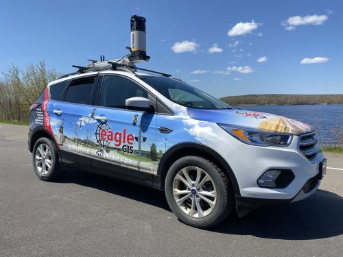
Instead of traditional data collection techniques, Eagle GIS is using a 360 Mapping Vehicle with a mobile mapping camera and a real-time mobile GIS solution. This unique method has helped produce the fibre-network, high-speed internet in rural Atlantic Canada, such as the First Nations community in Cape Breton, Nova Scotia. This effective technique has helped technicians map 600 kilometres of Prince Edward Island in 2 and a half days instead of 60 days using the conventional data collection methods. Read more here
Expanding Sight: Plant health beyond the naked eye
The digital camera captures a three-colour image for every photography. The colours, red, green and blue, merge into the visible colours by the eye naked. For plants, more data can be collected by measuring more colours which means wavelengths exceeding red, green and blue. This technique is called spectroscopy.
The new technology provides the combination of imaging and spectroscopy to provide more in-depth information on plants. This technology is called Hyperspectral imaging that provides plant health monitoring using comprehensive plant conditions such as nitrogen status, infections, maturity index, and plant stress as a result of drought, unfavourable temperatures and other factors. Read more here


Be the first to comment