
- Mapping the Contested Arctic
- Feedback on Canada’s Internal Trade Legislation
- New Report Examines Link Between Murdered and Missing Indigenous Women and Human Trafficking in Canada
- CTV News Web Map Highlights Wildfires in Canada
- Satellite Imagery May Help to Predict Severe Wildfire Seasons in Canada
- OpenTopography Adds the High Resolution Digital Elevation Model
Mapping the Contested Arctic
As the Arctic becomes an increasingly contested space, many in Canada are concerned about the country’s Arctic security and sovereignty. During the Cold War, the Arctic was considered a crucial zone to both the Soviet Union and the United States, as it was seen as a corridor for any potential ballistic missile attacks between the two superpowers. While the Cold War has since ended, increased activity means that Canada should be more concerned about its role in the Arctic. To help better understand the complexities of today’s Arctic, Canadian Geographic has published a vibrant map of national boundaries, contested areas, natural resources, and military presence in the area.
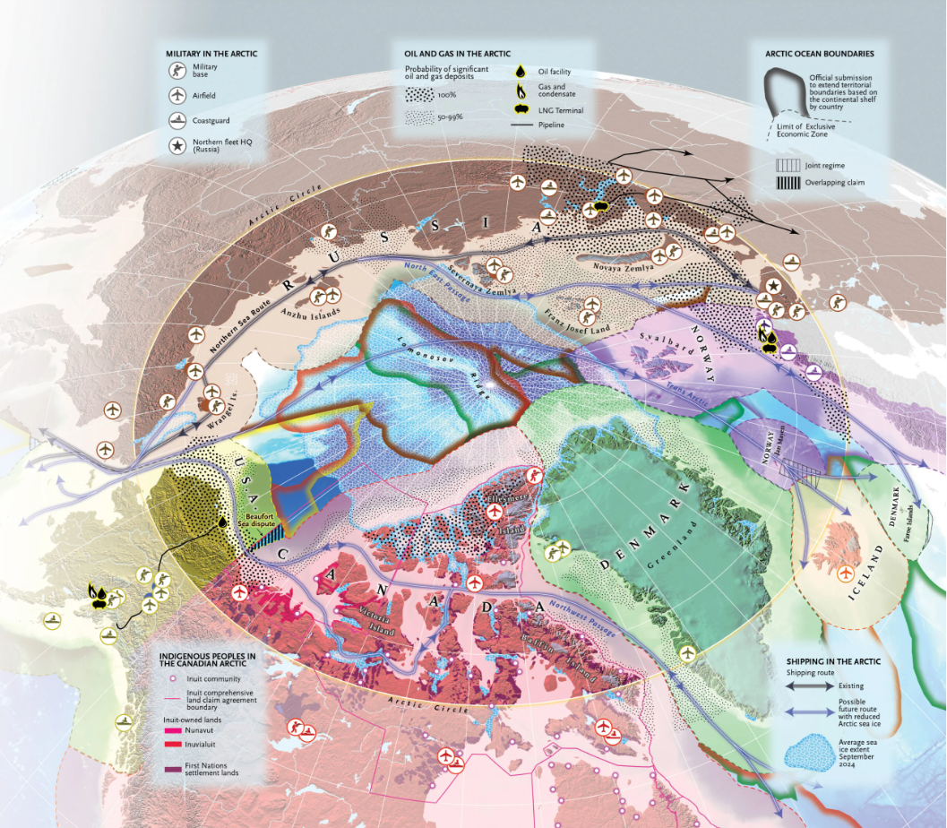
View a higher quality version of this map here
Feedback on Canada’s Internal Trade Legislation
The government of Canada is seeking public input on regulations under the recently passed Free Trade and Labour Mobility in Canada Act. The law, which was passed earlier this year as part of Bill C-5, aims to reduce bureaucracy by providing federal recognition of applicable legal requirements and licenses if a comparable standard has been met in a province or territory. Regulators are interested in possible exemptions to the Act, clarifying the definition of “comparable” and any other issues or concerns raised by the public. Interested parties can submit written comments to Intergovernmental Affairs – Internal Trade within the Privy Council Office by August 22nd.
Read more here
New Report Examines Link Between Murdered and Missing Indigenous Women and Human Trafficking in Canada
Thomas Reuters recently published a report titled Missing and Stolen: Disappearances and Tracking of Indigenous Peoples in Canada examining the relationship between murdered and missing indigenous women (MMIW) and advertisements for sexual encounters. Through geospatial analysis, researchers found a link between MMIW cases and advertisements for sexual encounters involving indigenous women. The report outlines important considerations for law enforcement and the community, including the need for a national database for the disappearance of indigenous people, the integration of sexual advertisement data into MMIW cases, the need to prioritize urban hot spots such as Winnipeg and Edmonton and the need for increased cross-border collaboration on sex trafficking with the United States.
Read the press release here
CTV News Web Map Highlights Wildfires in Canada
Atlantic Canada has been battling major wildfires just as Agriculture Canada has stated that 56% of the region is considered abnormally dry. Last week, the Province of Newfoundland and Labrador declared a state of emergency and ordered residents in the suburb of Paradise to evacuate their homes. Elsewhere, New Brunswick and Nova Scotia have also been battling major wildfires. To better understand the impact, status and scale of wildfires in Canada, CTV News has published a dynamic web map for user to access.
Read more here
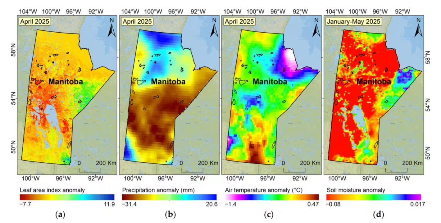
Satellite Imagery May Help to Predict Severe Wildfire Seasons in Canada
Researchers from the University of Ottawa and Université Laval recently published a study in the journal Earth examining conditions for the catastrophic wildfire season in Manitoba. Utilizing satellite imagery, researchers found that a combination of low precipitation, early snow melt and dry soil and vegetation could be found in the imagery, indicating the preconditions for a severe wildfire season. This study highlights how remote sensing and satellite imagery can be leveraged to identify potentially severe wildfire outbreaks. In 2029, Canada plans to launch the satellite WildFireSat to help track the country’s wildfires.
Read more here
OpenTopography Adds the High Resolution Digital Elevation Model
OpenTopography has added Natural Resource Canada’s High Resolution Digital Elevation Model (HRDEM) to its catalogue. The HRDEM was produced by Natural Resource Canada as part of its CanElevation series and covers much of southern Canada with a 1 meter resolution. HRDEM is free for academic use and can be licensed by commercial and international users though an OT+ subscription. For those looking to work with data from northern Canada, OpenTopography hosts another collection called the Arctic DEM.
Read more here


Be the first to comment