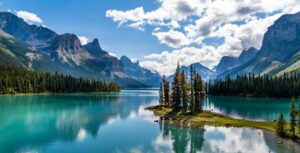
- Strategic tree planting could help Canada become carbon neutral by mid-century
- Canada Is Building a Surveillance Network in Space
- Pierre Polievre wants a Churchill base, but experts debate northern Manitoba town’s military capacity
- Concordia study finds snow droughts in western and southern Canada could affect nearly all Canadians
- Strengthen Community Resilience with the Wildfire Protection and Planning Solution
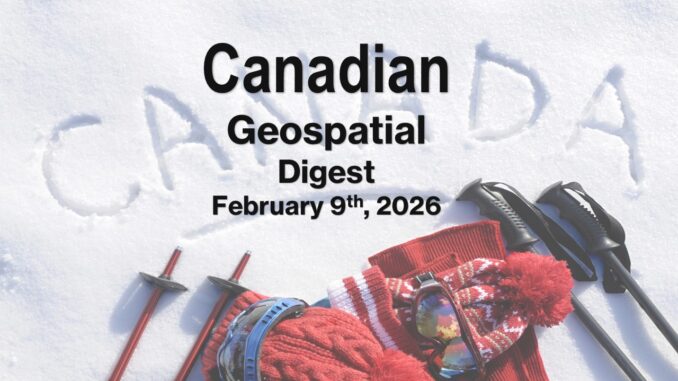
Strategic tree planting could help Canada become carbon neutral by mid-century
Researchers at the University of Waterloo have recently published a new study which can help Canada to “remove at least five times its annual carbon emissions with strategic planting of more than six million hectares of trees along the northern edge of the boreal forest”. Satellite data, statistical fire probability, vegetation loss, and other climate variables, are used in the estimated calculations for how much carbon the forests would remove.
The findings determined that “planting about 6.4 million hectares of trees in that region could remove roughly 3.9 gigatonnes of CO₂ by 2100. Scaling up to the most suitable areas increased the potential to around 19 gigatonnes”.
Geospatial tactics help play a major role in this procedure, especially mapping the highest yield zones using remote sensing. Since Canada’s northern geography is highly variable with wetlands and muskeg, lakes, rivers, and poor tree planting zones, remote sensing can quickly and decisively find the best spots as well as avoid the zones that are not worth the time to visit. This also helps field staff to map the best routes and for efficiency and safety in these remote areas. Read more here and here.
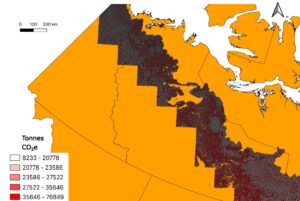
Canada Is Building a Surveillance Network in Space
Scientist-entrepreneur Brendan Quine is pursuing the restoration of a Canadian Cold-War relic, the Algonquin Radio Observatory (ARO). Brendan Quine’s pursuit is to use Canada’s largest radio telescope as a powerful and low-cost radar system that can detect small objects within Earth’s orbit for tracking satellites, debris, and other suspicious activity. The overall goal is to know what objects are in space, what they are doing, and whether they are a threat. With a record amount of satellites being launched per year, it’s becoming a wise investment to track them to help avoid the risk of collision, miscalculations, or deliberate attacks.
Canada itself is in a position of high risk with regards to the information space race. With the national economy relying on roughly 20 percent on space-enabled systems and an increase in need for national defence, intentional disruptions could be extremely costly to the Canadian economy. Canada is in a position where it needs to be a major player in the information space race, and geospatial professionals, much like Brendan Quine’s entrepreneurial spirit, will be the leaders in this initiative. Read more here.
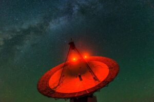
Pierre Polievre wants a Churchill base, but experts debate northern Manitoba town’s military capacity
Pierre Polievre has recently pushed forward an initiative to further strengthen Canada’s Arctic sovereignty. With Arctic passages opening up, Pierre Polievre argues that establishing a military base in Churchill, Manitoba, located along Manitoba’s northern coastline on the Hudson Bay, will reduce reliance on allies, redevelop the town’s port, and improve Canada’s ability to defend the North. However, defence experts warn that the site is poorly located and that small towns lack the infrastructure which would require a lot of upfront cost.
With Canada’s somewhat lack of a defence plan, geospatial tech can not only help find more optimal locations for bases in Canada, as well as address the need for higher grade defence and monitoring tech through satellite imagery. Northern Canada being as remote as it is, the lack of infrastructure and population makes it difficult to navigate to, so geospatial tech can help make up for the lack of information that would otherwise be difficult to retrieve. Read more here.
Concordia study finds snow droughts in western and southern Canada could affect nearly all Canadians
Concordia University researchers have started measuring usable water with a method called Snow Water Availability (SWA). The method measures snowpack while using satellite observations and climate data to assess snow depth, density, and coverage more precisely than traditional approaches.
The key findings determined that there’s been significant declines in snow water at mid-elevation regions of the Canadian Rockies, which has also caused many major rivers to receive less water supply. By measuring these seasonal incidents, studies can help determine droughts before they happen. Read more here and here.
Strengthen Community Resilience with the Wildfire Protection and Planning Solution
Wildfire season has become a consistent issue in Canada, and is only getting longer and more destructive in more rural forested communities. Esri Canada’s ArcGIS Wildfire Protection and Planning solution aims to better help communities prepare, mitigate, and respond to wildfire risk trough geospatial predictive modeling.
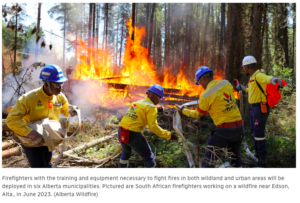
Planners and emergency managers can use these models to map wildfire hazards, assess risks, and identify vulnerable assets. Communities can then take this information and make actionable changes to help protect their communities. Read more here.


Be the first to comment