- Canada’s National Geomatics Expo
- MUNStar-1 Satellite Project Launched with Provincial Support
- GIS Tackles Homelessness in Abbotsford
- UK and Canada Partner on Redwing Microsatellite Mission
- GHGSat’s Vanguard Satellite Revolutionizes CO2 Monitoring
 Canada’s National Geomatics Expo 2024 was an outstanding success, showcasing the strength and innovation of the geomatics community. Held from October 28 to 30 in Calgary, the event brought together professionals and industry leaders from diverse fields, including BIM, GIS, Earth Observation, RPAS, Hydrography, SUE, Artificial Intelligence, Digital Twins, and Reality Capture.
Highlights of the expo included the buildingSMART Canada Annual BIM Summit, which provided insightful discussions on the digital transformation of the built environment, and the Canada Maps & Poster Gallery, which celebrated excellence in cartographic creativity. The trade show floor buzzed with energy, offering a platform for exhibitors to present cutting-edge technologies and solutions. Attendees also gained valuable knowledge through engaging speaker sessions and panels led by industry experts.
The success of the event would not have been possible without the generous support of our sponsors, speakers, exhibitors, and volunteers. We extend our heartfelt thanks to buildingSMART Canada for their collaboration and vision in advancing the BIM community. A special acknowledgment goes to our Platinum Sponsor, Eagle Engineering and Consulting, whose contributions helped make the event both memorable and impactful.
This year’s expo was a true celebration of collaboration and innovation, leaving attendees inspired and excited for the future of geomatics in Canada. Check out the photos
MUNStar-1 Satellite Project Launched with Provincial Support
Memorial University’s engineering students, in collaboration with C-CORE, are building MUNStar-1, a CubeSat to monitor ocean conditions using advanced GNSS Reflectometry. Supported by $350,000 from Newfoundland and Labrador’s Research Innovation Fund, alongside contributions from the Canadian Space Agency and C-CORE, the project trains future engineers and advances climate adaptation research. This initiative positions Memorial as a leader in space and ocean observation innovation. Read more here https://www.gov.nl.ca/releases/2024/iet/1114n02/
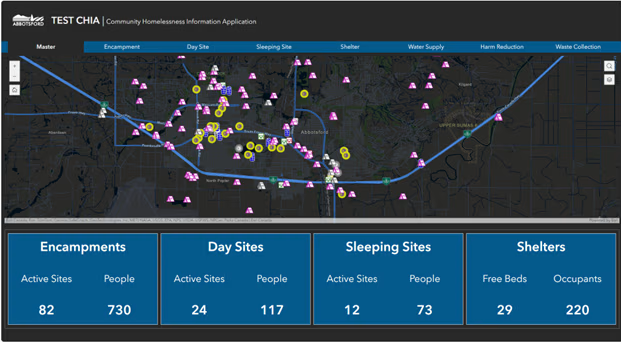
GIS Tackles Homelessness in Abbotsford

Abbotsford’s CHIA app, built with Esri ArcGIS, is transforming homelessness response by enabling real-time data collection, resource coordination, and service tracking. Since early 2024, it has logged over 2,000 updates and 1,700 resource deliveries, improving aid to vulnerable populations. CHIA showcases how GIS can address complex challenges through collaboration and actionable insights. Read more here https://resources.esri.ca/news-and-updates/addressing-homelessness-using-the-geographic-approach
UK and Canada Partner on Redwing Microsatellite Mission
The UK and Canada are collaborating on the Redwing microsatellite Space Domain Awareness (SDA) mission, set to launch in 2027. Redwing, directed by Defence Research and Development Canada (DRDC), will track orbital objects using advanced sensors, delivering near real-time updates. It will also deploy a nanosatellite, LISSA, equipped with a UK-designed short-wave infrared (SWIR) camera.
Operating in tandem at 575 km above Earth, the satellites aim to enhance monitoring of less-observed areas like the South Pole and improve space surveillance strategies. This mission marks a significant step in advancing security and innovation in the space domain for both nations.
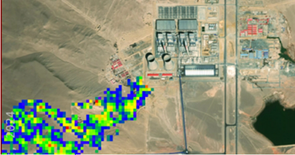
GHGSat’s Vanguard Satellite Revolutionizes CO2 Monitoring
 GHGSat unveiled the first carbon dioxide plume images from Vanguard, the world’s first satellite pinpointing CO2 emissions from individual facilities. Presented at COP29, the data highlights emissions from a power plant producing 12 Mt of CO2 annually.
Launched in 2023, Vanguard enhances emissions tracking, supports global carbon trading, and strengthens climate action, marking a major leap in greenhouse gas monitoring technology.


Be the first to comment