
- A European rival to Starlink pitches itself to Canada’s Armed Forces
- The startup Canada Rocket Company seeks to develop Canadian rocket capability
- The Government of Canada seeks proposal in support of data centre projects
- Interactive map highlights services inequalities between Waterloo Region neighbourhoods
- The number of Canadian payloads is growing significantly
- Canadian firm SkyWatch partners with Nearmap to expand access to aerial imagery
A European rival to Starlink pitches itself to Canada’s Armed Forces
The satellite operator Eutelsat has approached the Canadian government with a $250 million proposal to provide satellite imagery to the Canadian Armed Forces. While the Government of Canada is currently working alongside two local firms to develop satellite internet for the military, Eutelsat, owned largely by the Governments of France and the United Kingdom, has pitched itself as a further partner in the diversification of communication service providers.

Recently, there have been concerns about relying on a single partner for crucial services such as satellite internet. In 2022, the major satellite internet service provider Starlink unilaterally restricted internet access in Ukraine, raising fears of outside coercion.
Learn more here:
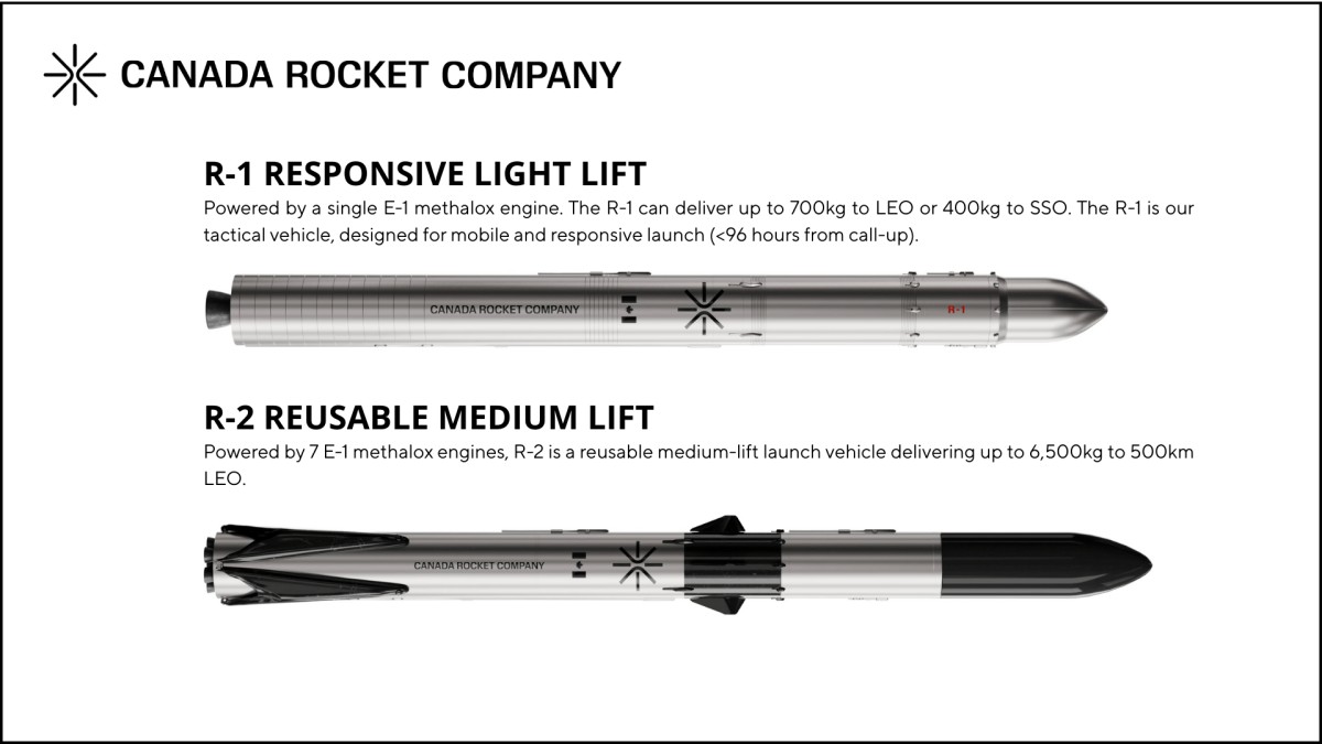
The startup Canada Rocket Company seeks to develop Canadian rocket capability
The Canada Rocket Company (CRC) is a Canadian startup with plans to create reusable small and medium-lift rockets. The CRC has already raised $6.2 million and has stated its intention to apply for funding through the Department of National Defence’s Launch the North program. CRC aims to foster homegrown talent, while supporting supply chains necessary for Canadian rocket development. CRC also hopes to repatriate existing Canadian talent back to the country.
Learn more here:
The Government of Canada seeks proposals in support of data centre projects

The Government of Canada has announced the opening of a proposal process for data centre development in Canada. Successful applicants will be given to opportunity to join with the Government of Canada in a MOU in order to “…explore mechanisms to enable the establishment of a large-scale sovereign AI data centre in Canada.”
The proposal process is open to developers with plans to construct a data centre with a minimum capacity of 1000 megawatts and plans to provide services to a broad customer base. When considering proposals, the Government will prioritize data centre development with a clear path to completion, indigenous partnership, sustainability considerations and the involvement of Canadian partners and supply chains.
Those that are interested should submit an intake form to the following email address. Learn more about the proposal process here:
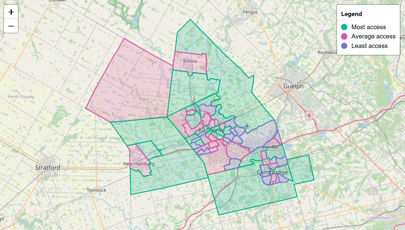
Interactive map highlights services inequalities between Waterloo Region neighbourhoods
The One Million Neighbours Waterloo Region, a group of 65 non-profit organizations and community groups, has released a service accessibility map for the Waterloo region. The map rates neighbourhoods based on access to green space, schools, libraries, health care, transit routes and community spaces. The aim of this project is to highlight areas of need and support the deployment of resources to improve the standard of services between regional neighbourhoods.
Learn more here:
The number of Canadian payloads is growing significantly
The total number of Canadian payloads (satellites and other senses) launched in 2026 is expected to reach 43 by the end of the year. The launch of 43 payloads is a significant increase over past years, with a total of 63 payloads being launched between 2021 and 2025. Canadian firms with planned 2026 launches include Kepler Communications, EarthDaily Analytics, GHGSat and NordSpace. There are presently 180 Canadian payloads planned for launch in 2027.
Learn more here:
Canadian firm SkyWatch partners with Nearmap to expand access to aerial imagery

The Canadian geospatial data platform provider SkyWatch has announced a partnership with Nearmap, a provider of high-resolution aerial imagery. Nearmap produces aerial images for urban areas in the United States, Canada, Australia and New Zealand tailored towards change detection and infrastructure monitoring. Through their partnership, SkyWatch will provide access to Nearmap’s imagery through its platforms such as the Content Store for ArcGIS, which is accessible to ArcGIS Online users.
Learn more here:


Be the first to comment